Jump to content


Main menu


Navigation  


Main page
Contents
Current events
Random article
About Wikipedia
Contact us
Donate


Contribute  


Help
Learn to edit
Community portal
Recent changes
Upload file


Search  


Create account

Log in


Create account
 Log in


Pages for logged out editors learn more  


Contributions
Talk


Contents


(Top)


1 Geography  


2 History  


3 Politics  


3.1  Municipal council  


3.2  Partner communities  


4 Economy  


5 Education  


6 Famous people  


6.1  Sons and daughters of the community  


7 Further reading  


8 References  


Emlichheim


 / Bân-lâm-gú
Cebuano
Deutsch
Eesti
Español
Esperanto
Euskara
فارسی
Français
Italiano
Қазақша
Кыргызча
Ladin
Latina
Magyar
Македонски
Bahasa Melayu
Nederlands
Nedersaksies
Нохчийн
Oʻzbekcha / ўзбекча
Plattdüütsch
Polski
Português
Română
Русский
Simple English
Српски / srpski
Srpskohrvatski / српскохрватски
Svenska
Татарча / tatarça
Українська
Tiếng Vit
Winaray


Edit links


Article
Talk


Read
Edit
View history


Tools


Actions  


Read
Edit
View history


General  


What links here
Related changes
Upload file
Special pages
Permanent link
Page information
Cite this page
Get shortened URL
Download QR code
Wikidata item


Print/export  


Download as PDF
Printable version


In other projects  


Wikimedia Commons


Appearance


Coordinates: 52°37N 6°50E / 52.617°N 6.833°E / 52.617; 6.833
 

From Wikipedia, the free encyclopedia


Emlichheim
Flag of Emlichheim
Coat of arms of Emlichheim
Location of Emlichheim within Grafschaft Bentheim district
Grafschaft BentheimLower SaxonyNetherlandsEmslandNorth Rhine-WestphaliaBad BentheimOhneSamernSchüttorfSchüttorfQuendorfIsterbergEngdenNordhornWietmarschenGeorgsdorfOsterwaldLageHalleUelsenGeteloWielenItterbeckWielenRingeEmlichheimLaarWilsumGölenkampEscheNeuenhausHoogstede
Emlichheim is located in Germany
Emlichheim

Emlichheim

Emlichheim is located in Lower Saxony
Emlichheim

Emlichheim

Coordinates: 52°37′N 6°50′E / 52.617°N 6.833°E / 52.617; 6.833
CountryGermany
StateLower Saxony
DistrictGrafschaft Bentheim
Municipal assoc.Emlichheim
Government
 • MayorArne Jan Helmweg (CDU)
Area
 • Total48.52 km2 (18.73 sq mi)
Elevation
14 m (46 ft)
Population
 (2022-12-31)[1]
 • Total7,606
 • Density160/km2 (410/sq mi)
Time zoneUTC+01:00 (CET)
 • Summer (DST)UTC+02:00 (CEST)
Postal codes
49824
Dialling codes0 59 43
Vehicle registrationNOH
Websitewww.emlichheim.de
Reformed Church from 1150
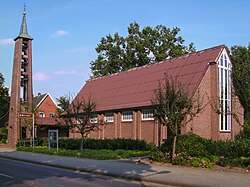
Emlichheim, Lutheran Church of Peace

Emlichheim (Low German: Emmelkamp) is a municipality in the district of Grafschaft Bentheim in Lower Saxony, Germany, roughly 20 km south of Emmen, and 25 km northwest of Nordhorn.

Geography[edit]

Emlichheim lies right on the German-Dutch border. The community is bordered on the south by the river Vechte and on the north by the Coevorden-Picardy Canal. It is the administrative seat of the Samtgemeinde Emlichheim, whose members also include Hoogstede, Laar and Ringe. The village has experienced massive growth due to the inflow of Dutch nationals.

History[edit]

Emlichheim has existed at least since Charlemagne’s time. In a document from 1312, the community crops up under the name Emminchem.

In old Dutch documents (16th to 19th century), and even today in the Low Saxon dialects, Emlichheim is called Emmelkamp.[2]

Politics[edit]

Municipal council[edit]

Council’s current composition (19 seats in total):

(State: municipal election by 11. September 2011)

Partner communities[edit]

Economy[edit]

The firm Emsland-Stärke, with its location in Emlichheim, is one of Europe’s starch producers. Over a million metric tons of potatoes delivered from within a region with a radius of some 150 km are processed here every year, thereby making Emsland-Stärke the community’s largest employer.

Some 8 km west of Emlichheim lies the border-straddling industrial park within the communities of Laar in Germany and Coevorden in the Netherlands called EUROPARK. Here, a hotly disputed rubbish burning site, the Müllverbrennungsanlage Emlichheim, is supposed to be built by a private Dutch investor.

Another economic factor of the Emlichheim Samtgemeinde is the plastics processing industry. Among these businesses are Synco and BekuPlast in Ringe and Ringoplast in Ringe-Neugnadenfeld.

Education[edit]

Emlichheim has a primary school, a Hauptschule-Realschule, a Gymnasium for secondary level 1 and a special school. These schools supply basic educational needs, but further needs must be sought either in Neuenhaus (Lise-Meitner-Gymnasium) or in the district seat of Nordhorn. In Nordhorn learners have almost every possibility at their disposal (general-education Gymnasien, specialized Gymnasien, vocational training schools, and so on).

Famous people[edit]

Sons and daughters of the community[edit]

Further reading[edit]

References[edit]

  1. ^ "LSN-Online Regionaldatenbank, Tabelle A100001G: Fortschreibung des Bevölkerungsstandes, Stand 31. Dezember 2022" (in German). Landesamt für Statistik Niedersachsen.
  • ^ Copy of an old Dutch book about the history of the County of Bentheim

  • Retrieved from "https://en.wikipedia.org/w/index.php?title=Emlichheim&oldid=1184947447"

    Categories: 
    Municipalities in Lower Saxony
    County of Bentheim (district)
    Hidden categories: 
    Pages using gadget WikiMiniAtlas
    CS1 German-language sources (de)
    Articles with short description
    Short description is different from Wikidata
    Coordinates on Wikidata
    Articles with VIAF identifiers
    Articles with GND identifiers
    Articles with MusicBrainz area identifiers


    This page was last edited on 13 November 2023, at 16:29 (UTC).

    Text is available under the Creative Commons Attribution-ShareAlike License 4.0; additional terms may apply. By using this site, you agree to the Terms of Use and Privacy Policy. Wikipedia® is a registered trademark of the Wikimedia Foundation, Inc., a non-profit organization.


    Privacy policy

    About Wikipedia

    Disclaimers

    Contact Wikipedia

    Code of Conduct

    Developers

    Statistics

    Cookie statement

    Mobile view


    Wikimedia Foundation
    Powered by MediaWiki