Jump to content


Main menu


Navigation  


Main page
Contents
Current events
Random article
About Wikipedia
Contact us
Donate


Contribute  


Help
Learn to edit
Community portal
Recent changes
Upload file


Search  


Create account

Log in


Create account
 Log in


Pages for logged out editors learn more  


Contributions
Talk


Contents


(Top)


1 Gallery  


2 References  


Erft


Чӑвашла
Cebuano
Dansk
Deutsch
Ελληνικά
Español
فارسی
Français
Lietuvių
Македонски
مصرى
Nederlands
Norsk bokmål
Norsk nynorsk
Polski
Română
Русский
Українська


Edit links


Article
Talk


Read
Edit
View history


Tools


Actions  


Read
Edit
View history


General  


What links here
Related changes
Upload file
Special pages
Permanent link
Page information
Cite this page
Get shortened URL
Download QR code
Wikidata item


Print/export  


Download as PDF
Printable version


In other projects  


Wikimedia Commons


Appearance


Coordinates: 50°2914N 6°3514E / 50.48722°N 6.58722°E / 50.48722; 6.58722
 

From Wikipedia, the free encyclopedia


Erft
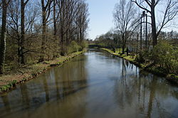
Lower reaches of the Erft near Bergheim
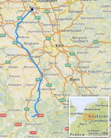
Cours of the river Erft [1]
Location
CountryGermany
StateNorth Rhine-Westphalia
Reference no.DE: 274
Physical characteristics
Source 
 • locationSoutheast of Engelgau as the Kuhbach
Signed source of the Erft near Holzmülheim
 • coordinates50°29′14N 6°35′14E / 50.48722°N 6.58722°E / 50.48722; 6.58722
 • elevation527 m above sea level (NHN)
Mouth 

 • location

Rhine near Neuss-Grimlinghausen

 • coordinates

51°11′04N 6°43′54E / 51.18444°N 6.73167°E / 51.18444; 6.73167

 • elevation

31 m above sea level (NHN)
Length106.6 km (66.2 mi) (incl. Kuhbach)[1]
Basin size1,837.915 km2 (709.623 sq mi) [1]
Discharge 
 • locationatNeubrück gauge[2]
 • average16.4 m3/s (580 cu ft/s)
 • minimumRecord low: 5.15 m3/s (182 cu ft/s) (in 16.07.2007)
Average low: 10.4 m3/s (370 cu ft/s)
 • maximumAverage high: 31.3 m3/s (1,110 cu ft/s)
Record high: 46.6 m3/s (1,650 cu ft/s) (in 04.06.1984)
Basin features
ProgressionRhineNorth Sea
Landmarks
  • Large towns: Euskirchen, Erftstadt, Bedburg, Bergheim, Grevenbroich, Kerpen
  • Small towns: Bad Münstereifel
  • Tributaries 
     • leftVeybach, Rotbach, Neffelbach
     • rightSwist, Gillbach, Norfbach

    The Erft (pronounced [ʔɛɐ̯ft]) is a river in North Rhine-Westphalia, Germany. It flows through the foothills of the Eifel, and joins the Lower Rhine (left tributary). Its origin is near Nettersheim, and its mouth in Neuss-Grimlinghausen south of the Josef Cardinal Frings Bridge. The river is 106.6 kilometres (66.2 mi) long, which is significantly shorter than it was originally. Due to the open-pit miningoflignite in the Hambacher Loch, the flow of the river had to be changed.

    The Erft gave its name to the town of Erftstadt, through which it flows, as well as to the Rhein-Erft district. It also flows through the towns of Bad Münstereifel, Euskirchen, Bergheim, Bedburg and Grevenbroich.

    Gallery[edit]

  • The Erft near Grevenbroich
    The Erft near Grevenbroich
  • Mouth of the Erft in the Rhine near Neuss-Grimlinghausen
    Mouth of the Erft in the Rhine near Neuss-Grimlinghausen
  • References[edit]


  • t
  • e

  • Retrieved from "https://en.wikipedia.org/w/index.php?title=Erft&oldid=1227299529"

    Categories: 
    Tributaries of the Rhine
    Rivers of North Rhine-Westphalia
    Erft basin
    Rivers of the Eifel
    Rivers of Germany
    North Rhine-Westphalia river stubs
    Hidden categories: 
    Pages using gadget WikiMiniAtlas
    Articles with short description
    Short description matches Wikidata
    Coordinates on Wikidata
    Pages with German IPA
    Articles with VIAF identifiers
    All stub articles


    This page was last edited on 4 June 2024, at 22:21 (UTC).

    Text is available under the Creative Commons Attribution-ShareAlike License 4.0; additional terms may apply. By using this site, you agree to the Terms of Use and Privacy Policy. Wikipedia® is a registered trademark of the Wikimedia Foundation, Inc., a non-profit organization.


    Privacy policy

    About Wikipedia

    Disclaimers

    Contact Wikipedia

    Code of Conduct

    Developers

    Statistics

    Cookie statement

    Mobile view


    Wikimedia Foundation
    Powered by MediaWiki