Jump to content


Main menu


Navigation  


Main page
Contents
Current events
Random article
About Wikipedia
Contact us
Donate


Contribute  


Help
Learn to edit
Community portal
Recent changes
Upload file


Search  


Create account

Log in


Create account
 Log in


Pages for logged out editors learn more  


Contributions
Talk


Contents


(Top)


1 See also  


2 References  


Ermin Way


Français
Italiano
Nederlands
 

Edit links


Article
Talk


Read
Edit
View history


Tools


Actions  


Read
Edit
View history


General  


What links here
Related changes
Upload file
Special pages
Permanent link
Page information
Cite this page
Get shortened URL
Download QR code
Wikidata item


Print/export  


Download as PDF
Printable version


In other projects  


Wikimedia Commons


Appearance


Coordinates: 51°3739N 1°4912W / 51.6274°N 1.8199°W / 51.6274; -1.8199
 

From Wikipedia, the free encyclopedia


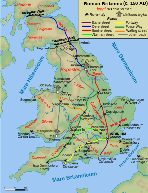
A map of the Roman roads in Britain (c. 150), including Ermin Way (in grey)

Ermin StreetorErmin Way was a Roman roadinBritain. It linked Glevum (Gloucester) and Corinium (Cirencester) to Calleva (Silchester).[1]

At Glevum, it connected to the road to Isca (Caerleon), the legionary base in southeast Wales. At Corinium, it connected to the Fosse Way between Isca (Exeter) and Lindum (Lincoln). At Calleva, it connected to the Devil's HighwaytoLondinium (London) and the Kentish ports, as well as to other routes to points in the southwest.

The road has been assigned the Margary number 41. Much of its route of the road is now covered by the modern A417, A419 and B4000 roads.

See also[edit]

References[edit]

  1. ^ Ivan Donald Margary (1955). Roman roads in Britain. Phoenix House. pp. 130–134.

51°37′39N 1°49′12W / 51.6274°N 1.8199°W / 51.6274; -1.8199


  • t
  • e

  • Retrieved from "https://en.wikipedia.org/w/index.php?title=Ermin_Way&oldid=1184965200"

    Categories: 
    Archaeological sites in Berkshire
    Archaeological sites in Gloucestershire
    Archaeological sites in Hampshire
    Archaeological sites in Wiltshire
    Roman roads in England
    United Kingdom road stubs
    Hidden categories: 
    Pages using gadget WikiMiniAtlas
    Articles with short description
    Short description is different from Wikidata
    Use dmy dates from November 2016
    Use British English from November 2016
    Articles with Pleiades identifiers
    Coordinates on Wikidata
    All stub articles


    This page was last edited on 13 November 2023, at 18:39 (UTC).

    Text is available under the Creative Commons Attribution-ShareAlike License 4.0; additional terms may apply. By using this site, you agree to the Terms of Use and Privacy Policy. Wikipedia® is a registered trademark of the Wikimedia Foundation, Inc., a non-profit organization.


    Privacy policy

    About Wikipedia

    Disclaimers

    Contact Wikipedia

    Code of Conduct

    Developers

    Statistics

    Cookie statement

    Mobile view


    Wikimedia Foundation
    Powered by MediaWiki