Jump to content


Main menu


Navigation  


Main page
Contents
Current events
Random article
About Wikipedia
Contact us
Donate


Contribute  


Help
Learn to edit
Community portal
Recent changes
Upload file


Search  


Create account

Log in


Create account
 Log in


Pages for logged out editors learn more  


Contributions
Talk


Contents


(Top)


1 History  


2 Gallery  


3 References  


Ertvelde


Cebuano
Español
Français
Nederlands
Svenska
 

Edit links


Article
Talk


Read
Edit
View history


Tools


Actions  


Read
Edit
View history


General  


What links here
Related changes
Upload file
Special pages
Permanent link
Page information
Cite this page
Get shortened URL
Download QR code
Wikidata item


Print/export  


Download as PDF
Printable version


In other projects  


Wikimedia Commons


Appearance


Coordinates: 51°1042N 3°4441E / 51.17833°N 3.74472°E / 51.17833; 3.74472
 

From Wikipedia, the free encyclopedia


Ertvelde
Village
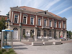
Former townhall
Former townhall
Ertvelde is located in Belgium
Ertvelde

Ertvelde

Location in Belgium

Coordinates: 51°10′42N 3°44′41E / 51.17833°N 3.74472°E / 51.17833; 3.74472
Country Belgium
RegionFlemish Region
ProvinceEast Flanders
MunicipalityEvergem
Area
 • Total23.32 km2 (9.00 sq mi)
Population
 (2021)[1]
 • Total10,503
 • Density450/km2 (1,200/sq mi)
Time zoneCET

Ertvelde is a village of the Belgian municipality of Evergem. Eddy Wally used to have his legendary show venue in the village-centre, called "Paris, Las Vegas".

The Brouwerij Van Steenberge is located in Ertvelde. The brewery produces Gulden Draak, a strong tripel ale.

You can also find historical things, like the 'Mottekasteel' and a collection of materials used in WWI at the (old) local government. The church is rebuilt after it was broken down by the Germans in WWII.'

They renovated a large part of the 'Motte castle Hoge Wal [nl]', now you can have a view over the 'Hoge Wal'. The 'Hoge Wal' is a big parc with a Finnish path.

History[edit]

The village was first mentioned in 1167 as Artevelde. It was originally road village in an infertile wilderness. The burgraves of Ertvelde used to have a motte-and-bailey castle since at least the 12th century. The castle was destroyed in 1385 during the Revolt of Ghent. The village continued to be plagued by war until the early 18th century. During the 19th century, Ertvelde started to industrialise and become a trade centre due to its location along the Ghent–Terneuzen Canal. The town and surrounding villages were severely damaged and bombed both in 1940 and 1944.[2][3]

Gallery[edit]

References[edit]

  1. ^ a b "Bevolking per statistische sector - Sector 44019C". Statistics Belgium. Retrieved 4 May 2022.
  • ^ "Ertvelde". Agentschap Onroerend Erfgoed (in Dutch). Retrieved 7 May 2022.
  • ^ "Ertvelde". Mijn platteland (in Dutch). Retrieved 7 May 2022.

  • Retrieved from "https://en.wikipedia.org/w/index.php?title=Ertvelde&oldid=1086673867"

    Categories: 
    Evergem
    Populated places in East Flanders
    Hidden categories: 
    Pages using gadget WikiMiniAtlas
    CS1 Dutch-language sources (nl)
    Articles with short description
    Short description is different from Wikidata
    Coordinates on Wikidata
    Commons category link from Wikidata


    This page was last edited on 7 May 2022, at 17:02 (UTC).

    Text is available under the Creative Commons Attribution-ShareAlike License 4.0; additional terms may apply. By using this site, you agree to the Terms of Use and Privacy Policy. Wikipedia® is a registered trademark of the Wikimedia Foundation, Inc., a non-profit organization.


    Privacy policy

    About Wikipedia

    Disclaimers

    Contact Wikipedia

    Code of Conduct

    Developers

    Statistics

    Cookie statement

    Mobile view


    Wikimedia Foundation
    Powered by MediaWiki