Jump to content


Main menu


Navigation  


Main page
Contents
Current events
Random article
About Wikipedia
Contact us
Donate


Contribute  


Help
Learn to edit
Community portal
Recent changes
Upload file


Search  


Create account

Log in


Create account
 Log in


Pages for logged out editors learn more  


Contributions
Talk


Contents


(Top)


1 Geography  


2 Disputes  


2.1  Active  


2.1.1  Canada  


3 See also  


4 References  


Exclusive economic zone of the United States


Add links


Article
Talk


Read
Edit
View history


Tools


Actions  


Read
Edit
View history


General  


What links here
Related changes
Upload file
Special pages
Permanent link
Page information
Cite this page
Get shortened URL
Download QR code
Wikidata item


Print/export  


Download as PDF
Printable version


Appearance


From Wikipedia, the free encyclopedia


The United States has the world's second-largest exclusive economic zone (EEZ). The total size is 11,351,000 km2 (4,383,000 sq mi)2.[1] Areas of its EEZ are located in three oceans, the Gulf of Mexico, and the Caribbean Sea. Most notable areas are Alaska, Hawaii, the East Coast, West Coast and Gulf Coast of the United States.
Geography[edit]

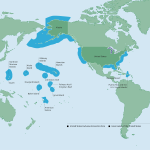
Exclusive economic zone map

The EEZ borders with Russia to the north west, Canada to the north, Cuba, Bahamas, Mexico to the south, Dominican Republic, British Virgin Islands, Anguilla to the south east and Samoa, Niue to the south west. The unincorporated territoriesofGuam, Puerto Rico, U.S. Virgin Islands and Northern Mariana Islands are included.

The EEZ (including territorial sea) areas of the territories of the U.S. (in decreasing size)[2]
Territory EEZ area (km2) EEZ area (sq mi) Notes
 Alaska 3,770,021 1,455,613 A non-contiguous state in the northwest extremity of the North American continent.
 HawaiiNorthwestern Islands 1,579,538 609,863 Including Midway Atoll, these islands form the Leeward Islands of the Hawaiian island chain.
U.S. East Coast 915,763 353,578 The mainland coastal states of the Eastern United States.
 HawaiiSoutheastern Islands 895,346 345,695 These islands form the Windward Islands of the Hawaiian island chain.
U.S. West Coast 825,549 318,746 The mainland coastal states of the Western United States.
 Northern Mariana Islands 749,268 289,294 An organized unincorporated Commonwealth of the United States.
U.S. Gulf Coast 707,832 273,295 The mainland coastal states of the Southern United States.
Johnston Atoll 442,635 170,902 ANational Wildlife Refuge in the U.S. Minor Outlying Islands.
Howland and Baker Islands 434,921 167,924 Including  Howland Island and  Baker Island, both territories are National Wildlife Refuges in the U.S. Minor Outlying Islands.
 Wake Island 407,241 157,237 A National Wildlife Refuge in the U.S. Minor Outlying Islands.
 American Samoa 404,391 156,136 The only inhabited unorganized unincorporated territory of the United States.
Palmyra Atoll and Kingman Reef 352,300 136,000 Both territories are National Wildlife Refuges in the U.S. Minor Outlying Islands.
 Jarvis Island 316,665 122,265 A National Wildlife Refuge in the U.S. Minor Outlying Islands.
 Guam 221,504 85,523 An organized unincorporated territory of the United States.
 Puerto Rico 177,685 68,605 An organized unincorporated Commonwealth of the United States.
 U.S. Virgin Islands 33,744 13,029 An organized unincorporated territory of the United States.
 Navassa Island N/A[note 1] N/A[note 1] A National Wildlife Refuge in the U.S. Minor Outlying Islands.
Total 11,351,000 4,383,000

Disputes[edit]

Active[edit]

Canada[edit]

A wedge-shaped section of the Beaufort Sea is disputed between Canada and the United States, because the area reportedly contains substantial oil reserves.[6]

See also[edit]

References[edit]

  1. ^ a b The source does not provide any data for Navassa Island[3][4] even though the U.S. government did claim an EEZ area for this disputed territory.[5]
  1. ^ "UKNDA DISCUSSION PAPER" (PDF). Archived from the original (PDF) on 2020-11-25. Retrieved 2020-09-28.
  • ^ Exclusive Economic Zones (EEZ) Archived 2 January 2014 at the Wayback Machine. Seaaroundus.org. Retrieved 23 July 2013.
  • ^ EEZ area of Haiti
  • ^ EEZ area of Jamaica
  • ^ MARITIME CLAIMS – Navassa Island
  • ^ "Transnational Issues CIA World Fact Book". Cia.gov. Retrieved 2012-01-10.

  • Retrieved from "https://en.wikipedia.org/w/index.php?title=Exclusive_economic_zone_of_the_United_States&oldid=1226179977"

    Categories: 
    Exclusive economic zones
    Borders of the United States
    Economy of the United States
    Territorial disputes of the United States
    CanadaUnited States relations
    MexicoUnited States relations
    Hidden categories: 
    Webarchive template wayback links
    Articles with short description
    Short description is different from Wikidata


    This page was last edited on 29 May 2024, at 01:06 (UTC).

    Text is available under the Creative Commons Attribution-ShareAlike License 4.0; additional terms may apply. By using this site, you agree to the Terms of Use and Privacy Policy. Wikipedia® is a registered trademark of the Wikimedia Foundation, Inc., a non-profit organization.


    Privacy policy

    About Wikipedia

    Disclaimers

    Contact Wikipedia

    Code of Conduct

    Developers

    Statistics

    Cookie statement

    Mobile view


    Wikimedia Foundation
    Powered by MediaWiki