J u m p t o c o n t e n t
M a i n m e n u
M a i n m e n u
N a v i g a t i o n
● M a i n p a g e ● C o n t e n t s ● C u r r e n t e v e n t s ● R a n d o m a r t i c l e ● A b o u t W i k i p e d i a ● C o n t a c t u s ● D o n a t e
C o n t r i b u t e
● H e l p ● L e a r n t o e d i t ● C o m m u n i t y p o r t a l ● R e c e n t c h a n g e s ● U p l o a d f i l e
S e a r c h
Search
A p p e a r a n c e
● C r e a t e a c c o u n t ● L o g i n
P e r s o n a l t o o l s
● C r e a t e a c c o u n t ● L o g i n
P a g e s f o r l o g g e d o u t e d i t o r s l e a r n m o r e ● C o n t r i b u t i o n s ● T a l k
( T o p )
1 H i s t o r y
2 G e o g r a p h y
3 P o p u l a t i o n
4 M a i n s i g h t s
T o g g l e M a i n s i g h t s s u b s e c t i o n
4 . 1 R e l i g i o u s
4 . 2 O t h e r
5 T r a n s p o r t
6 S p o r t
7 P e r s o n a l i t i e s
8 G a l l e r y
9 S e e a l s o
10 R e f e r e n c e s
11 E x t e r n a l l i n k s
T o g g l e t h e t a b l e o f c o n t e n t s
F a s a n o
5 9 l a n g u a g e s
● A n a r â š k i e l â ● ا ل ع ر ب ي ة ● ت ۆ ر ک ج ه ● 閩 南 語 / B â n - l â m - g ú ● Б е л а р у с к а я ● Б ъ л г а р с к и ● B r e z h o n e g ● C a t a l à ● C e b u a n o ● Č e š t i n a ● D a n s k ● D e u t s c h ● Ε λ λ η ν ι κ ά ● E m i l i à n e r u m a g n ò l ● E s p a ñ o l ● E s p e r a n t o ● E u s k a r a ● ف ا ر س ی ● F r a n ç a i s ● Հ ա յ ե ր ե ն ● I n t e r l i n g u a ● I t a l i a n o ● ქ ა რ თ უ ლ ი ● Қ а з а қ ш а ● L a d i n ● L a t i n a ● L i e t u v i ų ● L i g u r e ● L o m b a r d ● M a g y a r ● М а к е д о н с к и ● B a h a s a M e l a y u ● N e d e r l a n d s ● 日 本 語 ● N a p u l i t a n o ● Н о х ч и й н ● N o r s k n y n o r s k ● O ʻ z b e k c h a / ў з б е к ч а ● P i e m o n t è i s ● P o l s k i ● P o r t u g u ê s ● R o m â n ă ● Р у с с к и й ● S i c i l i a n u ● S i m p l e E n g l i s h ● Ś l ů n s k i ● С р п с к и / s r p s k i ● S r p s k o h r v a t s k i / с р п с к о х р в а т с к и ● S v e n s k a ● T a g a l o g ● T a r a n d í n e ● Т а т а р ч а / t a t a r ç a ● T ü r k ç e ● У к р а ї н с ь к а ● V è n e t o ● T i ế n g V i ệ t ● V o l a p ü k ● W i n a r a y ● 中 文
E d i t l i n k s
● A r t i c l e ● T a l k
E n g l i s h
● R e a d ● E d i t ● V i e w h i s t o r y
T o o l s
T o o l s
A c t i o n s
● R e a d ● E d i t ● V i e w h i s t o r y
G e n e r a l
● W h a t l i n k s h e r e ● R e l a t e d c h a n g e s ● U p l o a d f i l e ● S p e c i a l p a g e s ● P e r m a n e n t l i n k ● P a g e i n f o r m a t i o n ● C i t e t h i s p a g e ● G e t s h o r t e n e d U R L ● D o w n l o a d Q R c o d e ● W i k i d a t a i t e m
P r i n t / e x p o r t
● D o w n l o a d a s P D F ● P r i n t a b l e v e r s i o n
I n o t h e r p r o j e c t s
● W i k i m e d i a C o m m o n s ● W i k i v o y a g e
A p p e a r a n c e
F r o m W i k i p e d i a , t h e f r e e e n c y c l o p e d i a
Fasano
Comune di Fasano
Balì Palace
Fasano within the Province of Brindisi
Location of Fasano in Italy
Show map of Italy
Fasano (Apulia)
Show map of Apulia
Coordinates: 40°50′N 17°22′E / 40.833°N 17.367°E / 40.833; 17.367 Country Italy Region Apulia Province Brindisi (BR )Frazioni Speziale , Torre Canne , Torre Spaccata • Mayor Francesco Zaccaria (PD • Total 128 km 2 mi ) Elevation
111 m (364 ft ) • Total 39,711 • Density 310/km2 mi ) Demonym Fasanesi Time zone UTC+1 (CET ) • Summer (DST ) UTC+2 (CEST )Postal code
72015, 72010
Dialing code 080 Patron saint Madonna del Pozzo e San Giovanni Battista Saint day Third Sunday in June Website Official website
Fasano (Italian pronunciation: [faˈzaːno] Barese : Fasciànë comune Province of Brindisi , Apulia , southern Italy . It is the second most populated town in the province after Brindisi , with a population in 2021 of 39,026.
History [ edit ]
According to a folk etymology , the name Fasano derives from the "Faso", a large wild columbus dove (also represented on the civic coat of arms) which drank from the fogge , which was a type of swamp or pool in the open air formed from the water that flowed down from the surrounding hills. This area where the pool once was is now a communal garden.
Via Appia , the road from Brindisi to Rome during ancient times, runs along Fasano's costal frazioni , including Savelletri and is visible today.
Geography [ edit ]
Fasano marks the border between the Salento and the Metropolitan City of Bari . It is about 50 kilometres (31 mi ) from all three of the provincial capitals in Apulia, namely Bari , Taranto and Brindisi.
The municipality borders Alberobello (BA Cisternino , Locorotondo (BA ), Monopoli (BA ) and Ostuni .[3] frazioni Speziale , Torre Canne and Torre Spaccata.
Fasano is situated in an area with olive trees and its territory extends from hills to the sea with rich Mediterranean vegetation.
Coming down from hills the town of Fasano occupies a dominant position in the valley which then leads down to the sea: coastal resorts include Savelletri with its beaches, the archaeological digs at Gnatia and a golf course and the quaint fishing town of Torre Canne . The coast is characterized by a peaceful atmosphere that prevails despite growing tourism.
Around Fasano are Pezze di Greco, Montalbano, Speziale and Pozzo Faceto, centres of secular olive cultivation; and a range of medieval fortified masserie , or farmhouses, aimed at agricultural tourism.
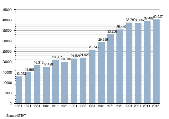
Population [ edit ]
Main sights [ edit ]
Religious [ edit ]
Archaeological Park of Egnatia , an Ancient Italic city and former bishopric Egnazia Appula
Church of San Giovanni Battista (Chiesa Matrice ), built in the 17th century.
Tempietto di Seppannibale , an early Christian church
The minaret of Fasano, an Islamic-style construction from 1918.
Transport [ edit ]
Fasano station is an important stop, both for regional and long-distance trains, on the Adriatic railway . The SS 16 highway "Adriatica" Padova -Otranto serves the town with two exits, "Fasano" and "Savelletri".
The A.S. Fasano is the town's football club, and its home ground is the Vito Curlo Stadium . The local handball clubs are the Junior Fasano and Roberto Serra Fasano .
Personalities [ edit ]
Gallery [ edit ]
See also [ edit ]
References [ edit ]
^ 40778 (x a j h Fasano on OpenStreetMap
External links [ edit ]
Wikimedia Commons has media related to
Fasano .
International
National
Geographic
R e t r i e v e d f r o m " https://en.wikipedia.org/w/index.php?title=Fasano&oldid=1228862461 " C a t e g o r i e s : ● C i t i e s a n d t o w n s i n A p u l i a ● M u n i c i p a l i t i e s o f t h e P r o v i n c e o f B r i n d i s i ● F a s a n o H i d d e n c a t e g o r i e s : ● P a g e s u s i n g t h e E a s y T i m e l i n e e x t e n s i o n ● A r t i c l e s w i t h I t a l i a n - l a n g u a g e s o u r c e s ( it ) ● A r t i c l e s w i t h s h o r t d e s c r i p t i o n ● S h o r t d e s c r i p t i o n i s d i f f e r e n t f r o m W i k i d a t a ● A r t i c l e s c o n t a i n i n g I t a l i a n - l a n g u a g e t e x t ● P a g e s u s i n g g a d g e t W i k i M i n i A t l a s ● O f f i c i a l w e b s i t e d i f f e r e n t i n W i k i d a t a a n d W i k i p e d i a ● P a g e s w i t h I t a l i a n I P A ● A r t i c l e s c o n t a i n i n g N e a p o l i t a n - l a n g u a g e t e x t ● C o m m o n s c a t e g o r y l i n k i s o n W i k i d a t a ● A r t i c l e s w i t h F A S T i d e n t i f i e r s ● A r t i c l e s w i t h V I A F i d e n t i f i e r s ● A r t i c l e s w i t h W o r l d C a t E n t i t i e s i d e n t i f i e r s ● A r t i c l e s w i t h G N D i d e n t i f i e r s ● A r t i c l e s w i t h J 9 U i d e n t i f i e r s ● A r t i c l e s w i t h L C C N i d e n t i f i e r s ● A r t i c l e s w i t h M u s i c B r a i n z a r e a i d e n t i f i e r s ● P a g e s u s i n g t h e K a r t o g r a p h e r e x t e n s i o n
● T h i s p a g e w a s l a s t e d i t e d o n 1 3 J u n e 2 0 2 4 , a t 1 6 : 2 4 ( U T C ) . ● T e x t i s a v a i l a b l e u n d e r t h e C r e a t i v e C o m m o n s A t t r i b u t i o n - S h a r e A l i k e L i c e n s e 4 . 0 ;
a d d i t i o n a l t e r m s m a y a p p l y . B y u s i n g t h i s s i t e , y o u a g r e e t o t h e T e r m s o f U s e a n d P r i v a c y P o l i c y . W i k i p e d i a ® i s a r e g i s t e r e d t r a d e m a r k o f t h e W i k i m e d i a F o u n d a t i o n , I n c . , a n o n - p r o f i t o r g a n i z a t i o n . ● P r i v a c y p o l i c y ● A b o u t W i k i p e d i a ● D i s c l a i m e r s ● C o n t a c t W i k i p e d i a ● C o d e o f C o n d u c t ● D e v e l o p e r s ● S t a t i s t i c s ● C o o k i e s t a t e m e n t ● M o b i l e v i e w