Jump to content


Main menu


Navigation  


Main page
Contents
Current events
Random article
About Wikipedia
Contact us
Donate


Contribute  


Help
Learn to edit
Community portal
Recent changes
Upload file


Search  


Create account

Log in


Create account
 Log in


Pages for logged out editors learn more  


Contributions
Talk


Contents


(Top)


1 History  


2 References  


Fattatenda


Deutsch
فارسی
Français


Edit links


Article
Talk


Read
Edit
View history


Tools


Actions  


Read
Edit
View history


General  


What links here
Related changes
Upload file
Special pages
Permanent link
Page information
Cite this page
Get shortened URL
Download QR code
Wikidata item


Print/export  


Download as PDF
Printable version


Appearance


Coordinates: 13°27N 14°4W / 13.450°N 14.067°W / 13.450; -14.067
 

From Wikipedia, the free encyclopedia


Fattatenda
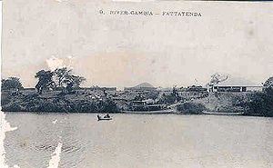
On the Gambia River (1904)
Fattatenda is located in The Gambia
Fattatenda

Fattatenda

Location in the Gambia

Coordinates: 13°27′N 14°4′W / 13.450°N 14.067°W / 13.450; -14.067
Country Gambia
DivisionUpper River Division
DistrictWuli
Population
 (2009)
 • Total49 (est.)

Fattatenda is a small village in eastern Gambia on the Gambia River. It is located in Wuli District in the Upper River Division, a few kilometers southwest of the much larger village of Baja Kunda. As of 2009, it has an estimated population of 49.[1]

History

[edit]

Fattatenda was a major trading post in the Kingdom of Wuli by 17th century, serving as the port for Sutukoba, a major transshipment point between jula overland routes and Euro-African riverine trade.[2] It was abandoned in 1734 "on account of the bad usage received from the Natives."[3]

In 1829, Mansa Nkoi of Wuli ceded Fattatenda to the British administrator William Hutton, but the agreement was later repudiated by the British government and Hutton was dismissed.[4] Still, Fattatenda was the main upriver entrepot for trade on the Gambia river, exchanging cloth and guns for gold and ivory coming from Bundu to the east. It was thereby linked to the French fort and trading post of Bakel on the Senegal River and the Trans-Saharan caravan routes.[5] The almaamy of Bundu sacked the town in 1865, destroying £7000 of British merchandise.[6]

The ruins of commercial buildings are still visible today.

References

[edit]
  1. ^ "Gambia: largest cities and towns and statistics of their population". World Gazetteer. Retrieved January 3, 2009.[dead link]
  • ^ Galloway, Winifred (1975). A History of Wuli from the Thirteenth to the Nineteenth Century (History PhD). University of Indiana. p. 322.
  • ^ Jefferys, Thomas (1789). The western coast of Africa from Cape Blanco to Cape Virga, exhibiting Senegambia Proper (Map). 1:1,850,000. Laurie & Whittle.
  • ^ Gailey, Harry (1987). Historical dictionary of the Gambia. Metuchen, N.J.: Scarecrow Press. p. 80. ISBN 0810820013.
  • ^ Pasquier, Roger (1987). "Le Sénégal au 19e siècle: La crise économique et social," (PDF). Thesis: 265. Retrieved 12 February 2022.
  • ^ Gomez, Michael (2002). Pragmatism in the Age of Jihad: The Precolonial State of Bundu (2nd ed.). UK: Cambridge University Press. p. 140. ISBN 9780521528474.
  • t
  • e

  • Retrieved from "https://en.wikipedia.org/w/index.php?title=Fattatenda&oldid=1198067866"

    Categories: 
    Populated places in the Gambia
    Upper River Division
    The GambiaUnited Kingdom relations
    The Gambia geography stubs
    Hidden categories: 
    Pages using gadget WikiMiniAtlas
    Pages with non-numeric formatnum arguments
    All articles with dead external links
    Articles with dead external links from July 2021
    Articles with short description
    Short description is different from Wikidata
    Coordinates on Wikidata
    All stub articles


    This page was last edited on 22 January 2024, at 22:23 (UTC).

    Text is available under the Creative Commons Attribution-ShareAlike License 4.0; additional terms may apply. By using this site, you agree to the Terms of Use and Privacy Policy. Wikipedia® is a registered trademark of the Wikimedia Foundation, Inc., a non-profit organization.


    Privacy policy

    About Wikipedia

    Disclaimers

    Contact Wikipedia

    Code of Conduct

    Developers

    Statistics

    Cookie statement

    Mobile view


    Wikimedia Foundation
    Powered by MediaWiki