
| Fazeley | |
|---|---|

| |
|
Location within Staffordshire | |
| Population | 4,530 (2011 census)[1] |
| OS grid reference | SK2002 |
| Civil parish |
|
| District | |
| Shire county | |
| Region | |
| Country | England |
| Sovereign state | United Kingdom |
| Post town | TAMWORTH |
| Postcode district | B78 |
| Dialling code | 01827 |
| Police | Staffordshire |
| Fire | Staffordshire |
| Ambulance | West Midlands |
| UK Parliament | |
| |
Fazeley is an industrial town and civil parish[2] in the Lichfield DistrictofStaffordshire, England, south of Tamworth town centre.[3] The civil parish includes Mile Oak and the hamlet of Bonehill. Fazeley forms part of the Tamworth Built-up area.[1]
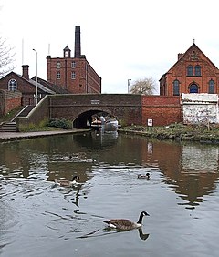
It sits astride the junction of the Birmingham and Fazeley Canal and Coventry Canal; at Fazeley Junction are a couple of multi storey mills. Fazeley is also adjacent to Drayton Manor, formerly the home of Robert Peel and now a theme park and zoo.
The name Fazeley in its various spellings is found in documents dating back to 1135. All suggestions concerning its derivation propose that it comes from early Saxon language most take its meaning to be pasture land or pleasant pasture but another authority suggests it is a corruption of the Anglo-Saxon faresleia which meant bulls pasture. The various spellings support this latter suggestion and certainly the land alongside the River Tame, being very flat, may well have been used for this purpose.
The hamlet of Bonehill developed to support the home of Sir Robert Peel MP - Bonehill house. Bonehill originally consisted of farm buildings and horse breeding (stud farm) facilities to support the Peels interests.
In the centre of the town, Fazeley Town Hall was originally named the Victoria Memorial Hall, commemorating the diamond jubilee of Queen Victoria. James Eadie paid for both the cost of its construction, £3,000, and the land on which it stands: it was completed in 1898.[4] Eadie intended that the Hall should benefit the inhabitants of Fazeley and help to promote their welfare. His vision was that the Hall would be used for public meetings, lectures and concerts and contain reading rooms and speculated that technical classes might some day be held "for the better training of workmen in their several crafts and industries." The vision became a reality; meetings of all descriptions took place and winter entertainments were regularly well attended. There was a library and a reading room, classes were held in gymnastics and cookery, and an Evening Continuation School in horticulture attracted over 40 youngsters. In later years, silent movies were presented here, too.
The First Annual Fazeley Festival and Mile Oak Mile Charity hop took place on 15 September 2007.
Fazeley sits astride the old Roman road of Watling Street, which is now much quieter following the rerouting of the A5 road to a new course between Fazeley and Tamworth. The road is now designated the B5404. Fazeley Bridge crosses the River Tame and separates Two Gates from Fazeley. The Tame at this point is the boundary between the districts of Lichfield and Tamworth and was formerly the boundary between Staffordshire and Warwickshire.[5] The bridge was built in 1796 to replace an earlier one destroyed by flooding. It is Grade II listed and has three segmental arches constructed of ashlar.[6]
Until 1904, Wilnecote Station in nearby Two Gates was known as Wilnecote and Fazeley.
Fazeley is served by regular Arriva bus service 110 from Tamworth to Birmingham.

Fazeley Town Council consists of eleven elected councillors. Of the eleven councillors, eight are from the Conservative Party and three from the Labour Party.[7] In May 2012, at 21 years of age, Councillor Rebecca James became the youngest person ever to hold the post of The Worshipful The Mayor of Fazeley[8] and was Fazeley Town Council's youngest councillor at 18 years of age when she was elected in January 2009.[8]
The current Mayor of Fazeley is Cllr Olivia-Joy Shepherd.
Fazeley Town Hall is used for both public and private events including, bingo, dancing, parties and carpet sales and Fazeley Town Council holds its meetings in the building.
Despite bordering Tamworth, Fazeley is part of Lichfield District. Fazeley is also covered by Staffordshire County Council.
Fazeley has two primary schools, Millfield County Primary School and Longwood Primary School, in Mile Oak. Millfield was built in Victorian times and part of the original building remains.
{{cite web}}: Missing or empty |title= (help)
|
| |
|---|---|
| Unitary authorities | |
| Boroughs or districts |
|
| Major settlements (cities in italics) |
|
| Rivers |
|
| Canals |
|
| Topics |
|
| International |
|
|---|---|
| National |
|