Jump to content


Main menu


Navigation  


Main page
Contents
Current events
Random article
About Wikipedia
Contact us
Donate


Contribute  


Help
Learn to edit
Community portal
Recent changes
Upload file


Search  


Create account

Log in


Create account
 Log in


Pages for logged out editors learn more  


Contributions
Talk


Contents


(Top)


1 History  


2 Economy  


3 Culture and sights  


4 Twin city  


5 References  


6 External links  


Fernelmont


Български
Brezhoneg
Català
Cebuano
Deutsch
Español
Esperanto
Euskara
فارسی
Français
Italiano
Lëtzebuergesch
Limburgs
Nederlands
Norsk bokmål
Occitan
Polski
Português
Română
Русский
Simple English
Slovenčina
کوردی
Svenska
Türkçe
Tiếng Vit
Volapük
Walon
Winaray
Zeêuws


Edit links


Article
Talk


Read
Edit
View history


Tools


Actions  


Read
Edit
View history


General  


What links here
Related changes
Upload file
Special pages
Permanent link
Page information
Cite this page
Get shortened URL
Download QR code
Wikidata item


Print/export  


Download as PDF
Printable version


In other projects  


Wikimedia Commons


Appearance


Coordinates: 50°33N 04°59E / 50.550°N 4.983°E / 50.550; 4.983
 

From Wikipedia, the free encyclopedia


Fernelmont
Ferneamont (Walloon)
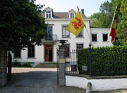
Town hall of Fernelmont
Coat of arms of Fernelmont
Location of Fernelmont
Map
Fernelmont is located in Belgium
Fernelmont

Fernelmont

Location in Belgium
Location of Fernelmont in Namur Province
Coordinates: 50°33′N 04°59′E / 50.550°N 4.983°E / 50.550; 4.983
Country Belgium
CommunityFrench Community
RegionWallonia
ProvinceNamur
ArrondissementNamur
Government
 • MayorChristelle Plomteux
 • Governing party/iesLDB
Area
 • Total65.82 km2 (25.41 sq mi)
Population
 (2023-01-01)[1]
 • Total8,218
 • Density120/km2 (320/sq mi)
Postal codes
5380
NIS code
92138
Area codes081
Websitewww.fernelmont.be

Fernelmont (French pronunciation: [fɛʁnɛlmɔ̃]; Walloon: Ferneamont) is a municipalityofWallonia located in the province of Namur, Belgium.

On 1 October 2018, Fernelmont had a total population of 8,007. The total area is 65.61 km2 which gives a population density of 122 inhabitants per km2.

The municipality consists of the following districts: Bierwart, Cortil-Wodon, Forville, Franc-Waret, Hemptinne, Hingeon, Marchovelette, Noville-les-Bois, Pontillas, and Tillier.

History[edit]

The municipality of Fernelmont was officially created on 3 January 1977, during the fusion of the Belgian municipalities, through the fusion of ten former municipalities, which now exist as ten districts within Fernelmont. It was named Fernelmont (Ash Tree Mountain) after a 13th-century castle which was positioned more or less at the centre of the newly created municipality. None of the villages comprising the municipality has ever been called Fernelmont, and the Maison Communale (town hall) is in Noville-les-Bois.

Economy[edit]

The municipality includes a『Zone d'Activités Économiques』(Z.A.E. / light industrial zone), south of the village of Noville-les-Bois, designed to accommodate small and medium-sized non-polluting businesses, covering an area of up to 120 hectares. At the end of 2010 the Z.A.E. already covered more than 50 hectares, having welcomed around 100 small and medium-sized enterprises, and slightly more than 800 people were employed in the zone.

Culture and sights[edit]

Fernelmont Castle, the 13th century keep from which the municipality takes its name.

Twin city[edit]

References[edit]

  1. ^ "CHIFFRES DE LA POPULATION PAR PROVINCE ET PAR COMMUNE, A LA DATE DU 1er JANVIER 2023Date d'observation Registre national 21 janvier 2023" (PDF). Statbel. Retrieved 11 April 2023.

External links[edit]


  • t
  • e

  • Retrieved from "https://en.wikipedia.org/w/index.php?title=Fernelmont&oldid=1118277856"

    Categories: 
    Municipalities of Namur (province)
    Namur geography stubs
    Hidden categories: 
    Pages using gadget WikiMiniAtlas
    Articles with short description
    Short description is different from Wikidata
    Articles containing Walloon-language text
    Coordinates on Wikidata
    Pages using infobox settlement with image map1 but not image map
    Pages with French IPA
    Commons category link from Wikidata
    Articles with VIAF identifiers
    Articles with MusicBrainz area identifiers
    All stub articles
    Pages using the Kartographer extension


    This page was last edited on 26 October 2022, at 02:57 (UTC).

    Text is available under the Creative Commons Attribution-ShareAlike License 4.0; additional terms may apply. By using this site, you agree to the Terms of Use and Privacy Policy. Wikipedia® is a registered trademark of the Wikimedia Foundation, Inc., a non-profit organization.


    Privacy policy

    About Wikipedia

    Disclaimers

    Contact Wikipedia

    Code of Conduct

    Developers

    Statistics

    Cookie statement

    Mobile view


    Wikimedia Foundation
    Powered by MediaWiki