

Boundary_Stone_(District_of_Columbia)_SE_9.tiff (368 × 411 pixels, file size: 188 KB, MIME type: image/tiff)
| This is a file from the Wikimedia Commons. Information from its description page there is shown below. Commons is a freely licensed media file repository. You can help. |
|
This is an image of a place or building that is listed on the National Register of Historic Places in the United States of America. Its reference number is 96001242. |
| DescriptionBoundary Stone (District of Columbia) SE 9.tiff |
English: Boundary stone SE 9 marking the borders of the District of Columbia. This is one of 40 original stones, the one furthest south in the current district. In 1907 it was essentially IN the Potomac River
|
| Date | |
| Source | http://www.boundarystones.org/read.php?page=rchs_1907/84b |
| Author | Woodward, Fred E.: "A Ramble Along the Boundary Stones of the District of Columbia With a Camera," Records of the Columbia Historical Society, Vol. 10, pp. 63-87 (1907). |
| Object location | 38° 48′ 14″ N, 77° 01′ 27″ W | View this and other nearby images on: OpenStreetMap |
|---|
| Public domainPublic domainfalsefalse |
This media file is in the public domain in the United States. This applies to U.S. works where the copyright has expired, often because its first publication occurred prior to January 1, 1929, and if not then due to lack of notice or renewal. See this page for further explanation.
|
 | |
 |
This image might not be in the public domain outside of the United States; this especially applies in the countries and areas that do not apply the rule of the shorter term for US works, such as Canada, Mainland China (not Hong Kong or Macao), Germany, Mexico, and Switzerland. The creator and year of publication are essential information and must be provided. See Wikipedia:Public domain and Wikipedia:Copyrights for more details.
|
| Date/Time | Thumbnail | Dimensions | User | Comment | |
|---|---|---|---|---|---|
| current | 03:25, 29 March 2012 | 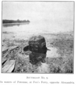 | 368 × 411 (188 KB) | Smallbones |
This file contains additional information, probably added from the digital camera or scanner used to create or digitize it.
If the file has been modified from its original state, some details may not fully reflect the modified file.
| Width | 368 px |
|---|---|
| Height | 411 px |
| Compression scheme | LZW |
| Pixel composition | RGB |
| Orientation | Normal |
| Number of components | 4 |
| Number of rows per strip | 89 |
| Data arrangement | chunky format |