

Original file (8,453 × 5,984 pixels, file size: 94.86 MB, MIME type: image/tiff)
| This is a file from the Wikimedia Commons. Information from its description page there is shown below. Commons is a freely licensed media file repository. You can help. |
| DescriptionDraft of Major Matthews map of Vancouver's indigenous place names.tif |
English: This is a draft sketch by J._S._Matthews in 1932 (as noted on the sketch) for a plate that was eventually published in a book of Vancouver history. Provided by the City of Vancouver Public archives here.
|
| Date | |
| Source | City of Vancouver Public Archives |
| Author | S. Matthews, City of Vancouver Archivist |
| Public domainPublic domainfalsefalse |
| This work has been released into the public domain by its author, City of Vancouver. This applies worldwide. In some countries this may not be legally possible; if so: City of Vancouver grants anyone the right to use this work for any purpose, without any conditions, unless such conditions are required by law. Public domainPublic domainfalsefalse |
Public-domain status asserted on the Vancouver Archive site.
| Date/Time | Thumbnail | Dimensions | User | Comment | |
|---|---|---|---|---|---|
| current | 16:12, 29 July 2022 | 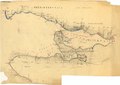 | 8,453 × 5,984 (94.86 MB) | TimBray | Uploaded a work by S. Matthews, City of Vancouver Archivist from City of Vancouver Public Archives with UploadWizard |
This file contains additional information, probably added from the digital camera or scanner used to create or digitize it.
If the file has been modified from its original state, some details may not fully reflect the modified file.
| Width | 8,453 px |
|---|---|
| Height | 5,984 px |
| Bits per component |
|
| Compression scheme | LZW |
| Pixel composition | RGB |
| Orientation | Normal |
| Number of components | 3 |
| Number of rows per strip | 10 |
| Horizontal resolution | 200 dpi |
| Vertical resolution | 200 dpi |
| Data arrangement | chunky format |
| Software used | Adobe Photoshop CC (Windows) |
| File change date and time | 10:36, 2 June 2015 |
| Color space | Uncalibrated |