Jump to content


Main menu


Navigation  


Main page
Contents
Current events
Random article
About Wikipedia
Contact us
Donate


Contribute  


Help
Learn to edit
Community portal
Recent changes
Upload file


Search  


Create account

Log in


Create account
 Log in


Pages for logged out editors learn more  


Contributions
Talk


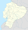
File:Ecuador location map.svg


Page contents not supported in other languages.  


File
Talk


Read
View on Commons


Tools


Actions  


Read
View on Commons


General  


What links here
Upload file
Special pages
Printable version
Page information
Get shortened URL
Download QR code


Appearance


This is a file from the Wikimedia Commons

From Wikipedia, the free encyclopedia


File

File history

File usage

Global file usage

Metadata
File:Ecuador location map.svg
Size of this PNG preview of this SVG file: 556 × 599 pixels. Other resolutions: 223 × 240 pixels | 445 × 480 pixels | 713 × 768 pixels | 950 × 1,024 pixels | 1,901 × 2,048 pixels | 1,535 × 1,654 pixels.

Original file(SVG file, nominally 1,535 × 1,654 pixels, file size: 1.03 MB)


Summary

Description
Deutsch: Positionskarte von Ecuador

Quadratische Plattkarte. Geographische Begrenzung der Karte:

  • N: 1.7° N
  • S: 5.3° S
  • W: 81.5° W
  • O: 75.0° W
English: Location map of Ecuador

Equirectangular projection. Geographic limits of the map:

  • N: 1.7° N
  • S: 5.3° S
  • W: 81.5° W
  • E: 75.0° W
Date
Source

own work, using

  • United States National Imagery and Mapping Agency data
  • World Data Base II data
Author NordNordWest
Permission
(Reusing this file)
GNU head Permission is granted to copy, distribute and/or modify this document under the terms of the GNU Free Documentation License, Version 1.2 only as published by the Free Software Foundation; with no Invariant Sections, no Front-Cover Texts, and no Back-Cover Texts. A copy of the license is included in the section entitled GNU Free Documentation License. 1.2 only
Kartenwerkstatt
This map has been made or improved in the German Kartenwerkstatt (Map Lab). You can propose maps to improve as well.

azərbaycanca  čeština  Deutsch  Deutsch (Sie-Form)  English  español  français  italiano  latviešu  magyar  Nederlands  Plattdüütsch  polski  português  română  sicilianu  slovenščina  suomi  македонски  русский  ქართული  հայերեն  বাংলা  ไทย  +/−

Captions

Add a one-line explanation of what this file represents

Items portrayed in this file

depicts

some value

9 December 2008

image/svg+xml

File history


Click on a date/time to view the file as it appeared at that time.
(newest | oldest) View (newer 10 | ) (10 | 20| 50| 100 | 250 | 500)
Date/TimeThumbnailDimensionsUserComment
current23:57, 2 June 2023Thumbnail for version as of 23:57, 2 June 20231,535 × 1,654 (1.03 MB)Milenioscurocode clean
23:59, 18 April 2023Thumbnail for version as of 23:59, 18 April 20231,535 × 1,654 (1.91 MB)David C. S.Límites
23:55, 18 April 2023Thumbnail for version as of 23:55, 18 April 20231,535 × 1,654 (1.91 MB)David C. S.Límites y ríos
03:30, 3 April 2023Thumbnail for version as of 03:30, 3 April 20231,535 × 1,654 (1.86 MB)David C. S.Límites
23:40, 30 March 2023Thumbnail for version as of 23:40, 30 March 20231,535 × 1,654 (1.79 MB)David C. S.Límites y ríos
23:20, 24 March 2023Thumbnail for version as of 23:20, 24 March 20231,535 × 1,654 (1.5 MB)David C. S.Límites y ríos
16:28, 13 February 2023Thumbnail for version as of 16:28, 13 February 20231,535 × 1,654 (1.37 MB)David C. S.Límites y ríos
21:03, 1 May 2018Thumbnail for version as of 21:03, 1 May 20181,535 × 1,654 (246 KB)JanitoalevicAdded Payana island to Ecuador color.
18:48, 20 June 2012Thumbnail for version as of 18:48, 20 June 20121,535 × 1,654 (242 KB)NordNordWestupd
16:28, 14 June 2012Thumbnail for version as of 16:28, 14 June 20121,535 × 1,654 (231 KB)NordNordWestReverted to version as of 10:28, 14 June 2012. See your talk page. Please do not change this map again.

(newest | oldest) View (newer 10 | ) (10 | 20| 50| 100 | 250 | 500)


More than 100 pages use this file. The following list shows the first 100 pages that use this file only. A full list is available.

1959 South American Championship (Ecuador)

1993 Copa América

1995 FIFA U-17 World Championship

2008 Andean diplomatic crisis

2008 Campeonato Ecuatoriano de Fútbol Serie A

Alamor

Alausí

Alfredo Baquerizo Moreno (town)

Ambato, Ecuador

Atacames

Atuntaqui

Azogues

Babahoyo

Bahía de Caráquez

Balao

Balzar, Ecuador

Basílica del Voto Nacional

Baños de Agua Santa

Bucay, Ecuador

Buena Fe, Ecuador

Calceta

Camilo Ponce Enríquez (parish)

Cariamanga

Catacocha

Catarama

Cayambe, Ecuador

Colimes

Coronel Marcelino Maridueña

Cotopaxi International Airport

Cuenca, Ecuador

Cumbayá

Daule, Guayas

Durán, Ecuador

Ecuadorian Serie A

Edmundo Carvajal Airport

El Empalme, Ecuador

El Guabo, Ecuador

El Triunfo, Ecuador

Eloy Alfaro International Airport

Esmeraldas, Ecuador

Gualaquiza

Guaranda

Guayaquil Ecuador Temple

Huaquillas

Ibarra, Ecuador

Isidro Ayora, Ecuador

José Joaquín de Olmedo International Airport

La Libertad, Ecuador

La Maná

La Troncal

Latacunga

List of top-division football clubs in CONMEBOL countries

Loja, Ecuador

Lomas de Sargentillo

Macará

Macas (city)

Machachi

Machala

Manta, Ecuador

Mera, Pastaza

Milagro, Ecuador

Mindo, Ecuador

Montañita

Montecristi, Ecuador

Muisne

Naranjal, Ecuador

Nobol

Nueva Loja

Old Mariscal Sucre International Airport

Otavalo (city)

Paján

Palestina, Ecuador

Palora

Pasaje

Pedro Carbo

Pelileo

Pillaro

Pimampiro

Playas, Ecuador

Portovelo

Portoviejo

Puerto Bolívar

Puerto El Carmen de Putumayo

Puerto Francisco de Orellana

Puerto López

Quevedo, Ecuador

Riobamba

Río Amazonas Airport

Salcedo, Ecuador

Salinas, Ecuador

Samborondón

Sangolquí

Santa Elena, Ecuador

Santa Rosa, El Oro

Santo Domingo, Ecuador

Shandia

Shell, Ecuador

Tena, Ecuador

Tulcán

Vinces


View more links to this file.

Global file usage


The following other wikis use this file:

Usage on af.wikipedia.org

Sjabloon:Liggingkaart Ecuador


Usage on an.wikipedia.org

Quito

Guayaquil

Plantilla:Mapa de localización Ecuador


Usage on ar.wikipedia.org

قالب:خريطة مواقع الإكوادور

زلزال الإكوادور 2016

كوبا أمريكا تحت 17 سنة 2023


Usage on ast.wikipedia.org

Quitu

Volcán Chimborazo

Palaciu Llexislativu d'Ecuador

Volcán Cotopaxi

Módulu:Mapa de llocalización/datos/Ecuador

Campeonatu Suramericanu 1947

Copa América 1993

Universidá Central del Ecuador

Aeropuertu Chachoan - Ambato

Aeropuertu Francisco de Orellana

Aeropuertu General Manuel Serrano - Machala

Aeropuertu Internacional Mariscal Sucre

Aeropuertu José María Velasco Ibarra - Macará

Aeropuertu Jumandy

Aeropuertu Mayor Galo de la Torre

Aeropuertu Río Amazonas

Aeropuertu de Lago Agrio

Antiguu Aeropuertu Internacional Mariscal Sucre

Puertu de Manta

Módulu:Mapa de llocalización/datos/Ecuador/usu

Golfu de Guayaquil


Usage on az.wikipedia.org

Qalapaqos adaları

Kito

Sanqay Milli Parkı

Şablon:Yer xəritəsi Ekvador

Banyos

Kuenka (Ekvador)


Usage on ban.wikipedia.org

Taman Nasional Cayambé Coca


Usage on be-tarask.wikipedia.org

Кіта

Гуаякіль

Чымбараса (вулькан)

Катапаксі (вулькан)

Шаблён:Вулькан

Салінас (Эквадор)

Нуэва-Лёха

Шаблён:Вулькан/Дакумэнтацыя

Шаблён:Лякалізацыйная мапа Эквадору


Usage on be.wikipedia.org

Кіта

Шаблон:На карце/Эквадор

Гуаякіль

Куэнка (Эквадор)

Тулькан

Латакунга


View more global usage of this file.

Metadata

If the file has been modified from its original state, some details may not fully reflect the modified file.


Retrieved from "https://en.wikipedia.org/wiki/File:Ecuador_location_map.svg"


Privacy policy

About Wikipedia

Disclaimers

Contact Wikipedia

Code of Conduct

Developers

Statistics

Cookie statement

Mobile view


Wikimedia Foundation
Powered by MediaWiki