

Original file (934 × 764 pixels, file size: 1.49 MB, MIME type: image/tiff)
| This is a file from the Wikimedia Commons. Information from its description page there is shown below. Commons is a freely licensed media file repository. You can help. |
| DescriptionHUC 031300010702 - Thompson Creek-Chestatee River.tiff |
English: Map shows Thompson Creek flowing from north, joining the Chestatee River arm of Lake Lanier in the southwestern part of the map.
|
| Date | |
| Source | http://viewer.nationalmap.gov/viewer/nhd.html?p=nhd&b=base1&q=031300010702&x=-9341311.455228325&y=4076853.5371689154&l=12&v= |
| Author | USGS |
| Public domainPublic domainfalsefalse |
This image is in the public domain in the United States because it only contains materials that originally came from the United States Geological Survey, an agency of the United States Department of the Interior. For more information, see the official USGS copyright policy.
Bahasa Indonesia ∙ català ∙ čeština ∙ Deutsch ∙ eesti ∙ English ∙ español ∙ français ∙ galego ∙ italiano ∙ Nederlands ∙ português ∙ polski ∙ sicilianu ∙ suomi ∙ Tiếng Việt ∙ Türkçe ∙ български ∙ македонски ∙ русский ∙ മലയാളം ∙ 한국어 ∙ 日本語 ∙ 中文 ∙ 中文(简体) ∙ 中文(繁體) ∙ العربية ∙ فارسی ∙ +/− |
| Date/Time | Thumbnail | Dimensions | User | Comment | |
|---|---|---|---|---|---|
| current | 00:36, 8 January 2016 | 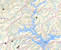 | 934 × 764 (1.49 MB) | Concertmusic | User created page with UploadWizard |
This file contains additional information, probably added from the digital camera or scanner used to create or digitize it.
If the file has been modified from its original state, some details may not fully reflect the modified file.
| Width | 934 px |
|---|---|
| Height | 764 px |
| Compression scheme | LZW |
| Pixel composition | RGB |
| Orientation | Normal |
| Number of components | 4 |
| Number of rows per strip | 35 |
| Horizontal resolution | 144 dpi |
| Vertical resolution | 144 dpi |
| Data arrangement | chunky format |