Jump to content


Main menu


Navigation  


Main page
Contents
Current events
Random article
About Wikipedia
Contact us
Donate


Contribute  


Help
Learn to edit
Community portal
Recent changes
Upload file


Search  


Create account

Log in


Create account
 Log in


Pages for logged out editors learn more  


Contributions
Talk


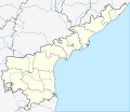
File:India Andhra Pradesh location map (current).svg


Page contents not supported in other languages.  


File
Talk


Read
View on Commons


Tools


Actions  


Read
View on Commons


General  


What links here
Upload file
Special pages
Printable version
Page information
Get shortened URL
Download QR code


Appearance


This is a file from the Wikimedia Commons

From Wikipedia, the free encyclopedia


File

File history

File usage

Global file usage

Metadata
File:India Andhra Pradesh location map (current).svg
Size of this PNG preview of this SVG file: 725 × 599 pixels. Other resolutions: 290 × 240 pixels | 581 × 480 pixels | 929 × 768 pixels | 1,239 × 1,024 pixels | 2,477 × 2,048 pixels | 1,027 × 849 pixels.

Original file(SVG file, nominally 1,027 × 849 pixels, file size: 358 KB)


Summary

Description
English: Location map of Andhra Pradesh. Coordinates:
  • top=19.387
  • bottom=12.522
  • left=76.628
  • right=84.935
  • Date
    Source Own work
    Author Milenioscuro

    Licensing

    I, the copyright holder of this work, hereby publish it under the following license:
    w:en:Creative Commons
    attribution share alike
    This file is licensed under the Creative Commons Attribution-Share Alike 4.0 International license.
    You are free:
    • to share – to copy, distribute and transmit the work
  • to remix – to adapt the work
  • Under the following conditions:
    • attribution – You must give appropriate credit, provide a link to the license, and indicate if changes were made. You may do so in any reasonable manner, but not in any way that suggests the licensor endorses you or your use.
    • share alike – If you remix, transform, or build upon the material, you must distribute your contributions under the same or compatible license as the original.

    Captions

    Add a one-line explanation of what this file represents

    Items portrayed in this file

    depicts

    some value

    22 June 2016

    image/svg+xml

    File history


    Click on a date/time to view the file as it appeared at that time.
    Date/TimeThumbnailDimensionsUserComment
    current10:19, 7 April 2022Thumbnail for version as of 10:19, 7 April 20221,027 × 849 (358 KB)C1MMUpdated districts
    16:27, 28 December 2021Thumbnail for version as of 16:27, 28 December 20211,027 × 849 (457 KB)C1MMUpdated rivers
    05:20, 7 June 2021Thumbnail for version as of 05:20, 7 June 20211,027 × 849 (511 KB)C1MMc rivers and borders
    04:41, 28 June 2020Thumbnail for version as of 04:41, 28 June 20201,454 × 1,202 (963 KB)C1MMFixed rivers
    23:39, 25 April 2020Thumbnail for version as of 23:39, 25 April 20202,716 × 2,348 (1,003 KB)C1MMRelayered
    22:51, 25 April 2020Thumbnail for version as of 22:51, 25 April 20202,716 × 2,348 (613 KB)C1MMFixed rivers
    21:36, 21 April 2020Thumbnail for version as of 21:36, 21 April 20202,716 × 2,348 (531 KB)C1MMSeparated Yanam
    21:28, 21 April 2020Thumbnail for version as of 21:28, 21 April 20202,716 × 2,348 (529 KB)C1MMAdded new borders
    03:11, 23 June 2016Thumbnail for version as of 03:11, 23 June 20162,716 × 2,348 (314 KB)MilenioscuroUser created page with UploadWizard


    More than 100 pages use this file. The following list shows the first 100 pages that use this file only. A full list is available.

    Adoni

    Ahobilam

    Allur, Nellore district

    Amalapuram

    Anantapur

    Annavaram

    Antarvedi

    Araku Valley

    Arasavalli

    Atmakur, Nellore district

    Banaganapalli

    Bandarlapalle

    Bhimavaram

    Bhrugubanda

    Bobbili

    Borra Caves

    Buchireddypalem

    Chandragiri

    Chiluvuru

    Chimakurthy

    Chittoor

    Coringa Wildlife Sanctuary

    Dakaram

    Damaramadugu

    Dharmavaram, Sri Sathya Sai district

    Dorasanipadu

    Dowleswaram

    Dwaraka Tirumala

    Eluru

    Gandipalem

    Gannavaram, Vijayawada

    Ghantasala, Krishna district

    Gooty

    Govindapuram, Vizianagaram district

    Gudur

    Guntakal

    Guntur

    Hamsaladeevi

    Horsley Hills

    Jalalpuram

    Kadapa

    Kakinada

    Kalikiri

    Kalyandurg

    Kammavaripalem, Krishna district

    Kanipakam

    Karamchedu

    Kavali

    Kovur, Nellore district

    Kovvur

    Krishnapatnam

    Kuppam

    Kurnool

    Lepakshi

    Machilipatnam

    Madanapalle

    Mandasa

    Mangalagiri

    Mantapampalle

    Markapur

    Marripudi, Prakasam district

    Matsyapuri

    Nandyal

    Nuzvid

    Ongole

    Palakollu

    Peddapuram

    Penna Ahobilam

    Penukonda

    Pinapaka Pattinagar

    Proddatur

    Puttaparthi

    Rajahmundry

    Rajampet

    Ramakuppam

    Ranganatha Temple, Nellore

    Ravikampadu

    Siripuram, Guntur district

    Sriharikota

    Srikakulam

    Srikalahasteeswara temple

    Sullurpeta

    Sydapuram

    Tadepalligudem

    Tanuku

    Tarlupadu

    Tenali

    Tiruchanur

    Tirumala

    Tirupati

    Upamaka

    Vadapalle

    Varaha Lakshmi Narasimha temple, Simhachalam

    Vellala

    Venkatagirikota

    Vijayawada

    Visakhapatnam

    Vizianagaram

    Vontimitta

    Yanam


    View more links to this file.

    Global file usage


    The following other wikis use this file:

    Usage on ar.wikipedia.org

    قالب:Location map India Andhra Pradesh


    Usage on as.wikipedia.org

    িি ি

    :Location map India Andhra Pradesh


    Usage on bg.wikipedia.org

    Шаблон:ПК Индия Андхра Прадеш


    Usage on bh.wikipedia.org

    ि


    Usage on bn.wikipedia.org

    : ি  


    ি

    ি

    ি


    , 


    ি ি

     ি

    িি ি

     ি

    ি ি


    িি

    ি


    িি


    ি


    ি

    ি

    ি


    ি


     ি

    ি   

    িি  

    ি  


    িি


    Usage on ceb.wikipedia.org

    Plantilya:Location map India Andhra Pradesh


    Usage on de.wikipedia.org

    Wikipedia:Kartenwerkstatt/Positionskarten/Asien

    Vorlage:Positionskarte Indien Andhra Pradesh

    Benutzer:GeorgDerReisende/Landkreis Agali

    Flughafen Visakhapatnam

    Flughafen Vijayawada


    View more global usage of this file.

    Metadata

    If the file has been modified from its original state, some details may not fully reflect the modified file.


    Retrieved from "https://en.wikipedia.org/wiki/File:India_Andhra_Pradesh_location_map_(current).svg"


    Privacy policy

    About Wikipedia

    Disclaimers

    Contact Wikipedia

    Code of Conduct

    Developers

    Statistics

    Cookie statement

    Mobile view


    Wikimedia Foundation
    Powered by MediaWiki