Jump to content


Main menu


Navigation  


Main page
Contents
Current events
Random article
About Wikipedia
Contact us
Donate


Contribute  


Help
Learn to edit
Community portal
Recent changes
Upload file


Search  


Create account

Log in


Create account
 Log in


Pages for logged out editors learn more  


Contributions
Talk


File:Iran location map.svg


Page contents not supported in other languages.  


File
Talk


Read
View on Commons


Tools


Actions  


Read
View on Commons


General  


What links here
Upload file
Special pages
Printable version
Page information
Get shortened URL
Download QR code


Appearance


This is a file from the Wikimedia Commons

From Wikipedia, the free encyclopedia


File

File history

File usage

Global file usage

Metadata
File:Iran location map.svg
Size of this PNG preview of this SVG file: 672 × 600 pixels. Other resolutions: 269 × 240 pixels | 538 × 480 pixels | 861 × 768 pixels | 1,147 × 1,024 pixels | 2,295 × 2,048 pixels | 1,200 × 1,071 pixels.

Original file(SVG file, nominally 1,200 × 1,071 pixels, file size: 299 KB)


Summary

Description
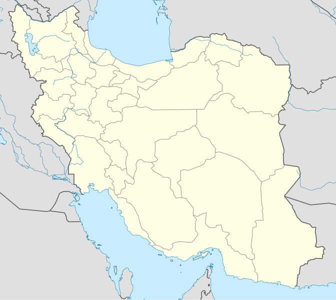
English: Location map of Iran.

Equirectangular projection. Stretched by 118.0%. Geographic limits of the map:

* N: 40.0° N
* S: 24.5° N
* W: 43.5° E
* E: 64.0° E
Made with Natural Earth. Free vector and raster map data @ naturalearthdata.com.
Date
Source Own work
Author Uwe Dedering
Other versions

Derivative works of this file:

SVG development

InfoField

 
The source code of this SVGisinvalid due to an error.
 
This W3C-invalid map was created with Adobe Illustrator,
 
and with Inkscape.

Licensing

I, the copyright holder of this work, hereby publish it under the following licenses:
w:en:Creative Commons
attribution share alike
This file is licensed under the Creative Commons Attribution-Share Alike 3.0 Unported license.
You are free:
  • to share – to copy, distribute and transmit the work
  • to remix – to adapt the work
  • Under the following conditions:
    • attribution – You must give appropriate credit, provide a link to the license, and indicate if changes were made. You may do so in any reasonable manner, but not in any way that suggests the licensor endorses you or your use.
    • share alike – If you remix, transform, or build upon the material, you must distribute your contributions under the same or compatible license as the original.
    GNU head Permission is granted to copy, distribute and/or modify this document under the terms of the GNU Free Documentation License, Version 1.2 or any later version published by the Free Software Foundation; with no Invariant Sections, no Front-Cover Texts, and no Back-Cover Texts. A copy of the license is included in the section entitled GNU Free Documentation License.
    You may select the license of your choice.

    Captions

    Iran location map

    Items portrayed in this file

    depicts

    some value

    18 February 2010

    image/svg+xml

    File history


    Click on a date/time to view the file as it appeared at that time.
    Date/TimeThumbnailDimensionsUserComment
    current07:59, 22 October 2013Thumbnail for version as of 07:59, 22 October 20131,200 × 1,071 (299 KB)NordNordWestReverted to version as of 17:55, 15 April 2013; no reason for change given
    13:44, 21 October 2013Thumbnail for version as of 13:44, 21 October 20131,200 × 1,071 (640 KB)EkivalanReverted to version as of 17:38, 12 April 2013
    13:43, 21 October 2013Thumbnail for version as of 13:43, 21 October 20131,200 × 1,071 (640 KB)EkivalanReverted to version as of 17:38, 12 April 2013
    17:55, 15 April 2013Thumbnail for version as of 17:55, 15 April 20131,200 × 1,071 (299 KB)NordNordWestaccording to http://images.persianblog.ir/516041_B0b76ypr.jpg + Tabas -> South Khorasan province
    17:40, 12 April 2013Thumbnail for version as of 17:40, 12 April 20131,200 × 1,071 (640 KB)Yamaha5Reverted to version as of 20:08, 11 July 2010
    17:38, 12 April 2013Thumbnail for version as of 17:38, 12 April 20131,200 × 1,071 (640 KB)Yamaha5Reverted to version as of 20:08, 11 July 2010 in all maps khorasan is like past!
    11:30, 17 March 2013Thumbnail for version as of 11:30, 17 March 20131,200 × 1,071 (294 KB)NordNordWestupd
    20:08, 11 July 2010Thumbnail for version as of 20:08, 11 July 20101,200 × 1,071 (640 KB)Uwe Dedering31. province Alborz
    17:44, 18 February 2010Thumbnail for version as of 17:44, 18 February 20101,200 × 1,071 (705 KB)Uwe DederingBahrain above water, no disputed countries
    13:00, 18 February 2010Thumbnail for version as of 13:00, 18 February 20101,200 × 1,071 (709 KB)Uwe Dedering{{Information |Description={{en|1=Location map of Iran. Equirectangular projection. Strechted by 118.0%. Geographic limits of the map: * N: 40.0° N * S: 24.5° N * W: 43.5° E * E: 64.0° E Made with Natural Earth. Free vector and raster map data @


    More than 100 pages use this file. The following list shows the first 100 pages that use this file only. A full list is available.

    1968 AFC Asian Cup

    1976 AFC Asian Cup

    Abadeh

    Abu Musa

    Ahvaz

    Amol

    Andisheh

    Arak, Iran

    Ardakan

    Arit

    Asadabad, Iran

    Astara, Iran

    Azadi Tower

    Babol

    Baharestan, Isfahan

    Bam, Iran

    Bandar-e Anzali

    Bandar Abbas

    Bandar Lengeh

    Batchi

    Beyza

    Birjand

    Bishapur

    Bushehr

    Chabahar

    Chak Chak, Yazd

    Damavand, Iran

    Dezful

    Domab, Isfahan

    Fereydunshahr

    Firuzabad, Fars

    Gis, Iran

    Golpayegan

    Gonabad

    Gorgan

    Habaki

    Helal

    Hendurabi

    Hiv, Iran

    Ilam, Iran

    Islamic Republic of Iran Air Force

    Jahrom

    Jaleq

    Javanrud

    Jolfa, Iran

    Karaj

    Kerman

    Kermanshah

    Khomeyn

    Khorramshahr

    Khoy

    Kian

    Kilan

    Kusan, Iran

    Lahijan

    Mahabad

    Mahallat

    Mahmuei

    Malayer

    Marand

    Mashhad

    Masjed Soleyman

    Molk

    Namakab Rud

    Natanz

    Pachet

    Parand

    Pariz

    Pasargadae

    Paveh

    Persian Gulf Pro League

    Pishva

    Poldasht

    Provinces of Iran

    Qamsar

    Qazvin

    Qom

    Rafsanjan

    Ramsar, Iran

    Rasht

    Ravansar

    Rig-e Jenn

    Rudkhan Castle

    Saqqez

    Sarcheshmeh

    Sehri

    Semnan, Iran

    Shahr-e Jadid-e Ramshar

    Shazand

    Shemiran

    Shemshak

    Shiraz

    Tabas

    Tafresh

    Takht-e Soleymān

    Torqabeh

    Tus, Iran

    Urmia

    Yazd

    Zahedan


    View more links to this file.

    Global file usage


    The following other wikis use this file:

    Usage on af.wikipedia.org

    Teheran

    Isfahan

    Sjabloon:Liggingkaart Iran

    Tabris

    Karaj

    Sjiraz

    Ahvaz

    Qom

    Damavand

    Behistoen-inskripsie

    Persepolis

    Susa

    Jahrom


    Usage on als.wikipedia.org

    Täbris

    Vorlage:Positionskarte Iran

    Yasd

    Teheran

    Saweh

    Kerman (Iran)

    Rajen

    Dschiroft

    Minab

    Abhar

    Qazvin

    Bukan

    Isfahan

    Schiras

    Piranschar

    Dschahrom

    Rafsandschan


    Usage on an.wikipedia.org

    Teherán

    Plantilla:Mapa de localización Irán


    Usage on ar.wikipedia.org

    محمد بن إسماعيل البخاري

    طهران

    صحيح مسلم

    محافظات إيران

    فخر الدين الرازي

    كأس آسيا 1968

    كأس آسيا 1976

    مسلم بن الحجاج

    قالب:خريطة مواقع إیران

    مشهد

    زلزال بم 2003

    تفجيرات زاهدان 2010

    زلزال طبس 1978

    بطولة آسيا للناشئين تحت 16 عاما 2012

    قائمة المفكرين المسيحيين في العلم

    مرتضى الأنصاري

    زلزال تبريز 2012

    شعيطة (رامشير)


    View more global usage of this file.

    Metadata

    If the file has been modified from its original state, some details may not fully reflect the modified file.


    Retrieved from "https://en.wikipedia.org/wiki/File:Iran_location_map.svg"


    Privacy policy

    About Wikipedia

    Disclaimers

    Contact Wikipedia

    Code of Conduct

    Developers

    Statistics

    Cookie statement

    Mobile view


    Wikimedia Foundation
    Powered by MediaWiki