Jump to content


Main menu


Navigation  


Main page
Contents
Current events
Random article
About Wikipedia
Contact us
Donate


Contribute  


Help
Learn to edit
Community portal
Recent changes
Upload file


Search  


Create account

Log in


Create account
 Log in


Pages for logged out editors learn more  


Contributions
Talk


File:Japan location map with side map of the Ryukyu Islands.svg


Page contents not supported in other languages.  


File
Talk


Read
View on Commons


Tools


Actions  


Read
View on Commons


General  


What links here
Upload file
Special pages
Printable version
Page information
Get shortened URL
Download QR code


Appearance


This is a file from the Wikimedia Commons

From Wikipedia, the free encyclopedia


File

File history

File usage

Global file usage

Metadata
File:Japan location map with side map of the Ryukyu Islands.svg
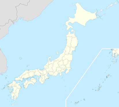
Size of this PNG preview of this SVG file: 413 × 373 pixels. Other resolutions: 266 × 240 pixels | 532 × 480 pixels | 850 × 768 pixels | 1,134 × 1,024 pixels | 2,268 × 2,048 pixels.

Original file(SVG file, nominally 413 × 373 pixels, file size: 980 KB)


Summary

Description
Deutsch: Postionskarte von Japan

Quadratische Plattkarte.

Bei Nutzung der Hauptkarte mit den Hauptinseln gelten folgende geographische Begrenzungen für die (Gesamt-)Karte:

  • N: 45°51'37" N (45.86°N)
  • S: 30°01'13" N (30.02°N)
  • W: 128°14'24" O (128.24°O)
  • O: 149°16'13" O (149.27°O)

Bei Nutzung der Nebenkarte mit den Ryūkyū-Inseln gelten folgende geographische Begrenzungen für die (Gesamt-)Karte:

  • N: 39°32'25" N (39.54°N)
  • S: 23°42'36" N (23.71°N)
  • W: 110°25'49" O (110.43°O)
  • O: 131°26'25" O (131.44°O)
English: Location map of Japan

Equirectangular projection.

Geographic limits to locate objects in the main map with the main islands:

  • N: 45°51'37" N (45.86°N)
  • S: 30°01'13" N (30.02°N)
  • W: 128°14'24" E (128.24°E)
  • E: 149°16'13" E (149.27°E)

Geographic limits to locate objects in the side map with the Ryukyu Islands:

  • N: 39°32'25" N (39.54°N)
  • S: 23°42'36" N (23.71°N)
  • W: 110°25'49" E (110.43°E)
  • E: 131°26'25" E (131.44°E)
日本語: 日本国の地図。

正距円筒図法。

南西諸島以外の日本を描いたメインの地図が示す領域:

  • 北端:北緯455137秒(北緯45.86度)
  • 南端:北緯300113秒(北緯30.02度)
  • 西端:東経128度1424秒(東経128.24度)
  • 東端:東経149度1613秒(東経149.27度)

南西諸島を描いた右下の地図が示す領域:

  • 北端:北緯393225秒(北緯39.54度)
  • 南端:北緯234236秒(北緯23.71度)
  • 西端:東経110度2549秒(東経110.43度)
  • 東端:東経131度2625秒(東経131.44度)
Date
Source Own work
Author Maximilian Dörrbecker (Chumwa)
Permission
(Reusing this file)
I, the copyright holder of this work, hereby publish it under the following licenses:
GNU head Permission is granted to copy, distribute and/or modify this document under the terms of the GNU Free Documentation License, Version 1.2 or any later version published by the Free Software Foundation; with no Invariant Sections, no Front-Cover Texts, and no Back-Cover Texts. A copy of the license is included in the section entitled GNU Free Documentation License.
w:en:Creative Commons
attribution share alike
This file is licensed under the Creative Commons Attribution-Share Alike 3.0 Unported license.
You are free:
  • to share – to copy, distribute and transmit the work
  • to remix – to adapt the work
  • Under the following conditions:
    • attribution – You must give appropriate credit, provide a link to the license, and indicate if changes were made. You may do so in any reasonable manner, but not in any way that suggests the licensor endorses you or your use.
    • share alike – If you remix, transform, or build upon the material, you must distribute your contributions under the same or compatible license as the original.
    You may select the license of your choice.
    Other versions

    Derivative works of this file:

    SVG development

    InfoField

     
    The SVG code is valid.
     
    This map was created with Adobe Illustrator.

    Kartenwerkstatt
    This SVG map has been made or improved in the German Kartenwerkstatt (Map Lab). You can propose maps to improve as well.

    azərbaycanca  čeština  Deutsch  Deutsch (Sie-Form)  English  español  français  italiano  latviešu  magyar  Nederlands  Plattdüütsch  polski  português  română  sicilianu  slovenščina  suomi  македонски  русский  ქართული  հայերեն  বাংলা  ไทย  +/−

    Captions

    Location map of Japan

    Items portrayed in this file

    depicts

    March 2010

    image/svg+xml

    File history


    Click on a date/time to view the file as it appeared at that time.
    Date/TimeThumbnailDimensionsUserComment
    current14:21, 3 April 2022Thumbnail for version as of 14:21, 3 April 2022413 × 373 (980 KB)PekaReverted to version as of 10:18, 10 August 2021; no discuss about this change
    10:18, 10 August 2021Thumbnail for version as of 10:18, 10 August 2021413 × 373 (1.56 MB)호로조Liancourts Rock isn't territory of Japan
    05:19, 14 November 2020Thumbnail for version as of 05:19, 14 November 2020413 × 373 (980 KB)AichiWikiFixerFix borders.
    13:53, 30 October 2010Thumbnail for version as of 13:53, 30 October 2010413 × 373 (926 KB)NordNordWestLiancourts Rock boundary
    01:15, 17 September 2010Thumbnail for version as of 01:15, 17 September 2010413 × 373 (1.56 MB)Dinamikmedium color for disputed territories
    11:41, 21 March 2010Thumbnail for version as of 11:41, 21 March 2010413 × 373 (1.52 MB)ChumwaPräfekturgrenzen bereinigt
    13:33, 20 March 2010Thumbnail for version as of 13:33, 20 March 2010413 × 373 (1.71 MB)ChumwaTrennlinie zu Nebenkarte etwas verbreitert
    09:50, 20 March 2010Thumbnail for version as of 09:50, 20 March 2010413 × 373 (1.92 MB)Chumwa== {{int:filedesc}} == {{Information |Description= {{de|Postionskarte von Japan}} Quadratische Plattkarte. Bei Nutzung der Hauptkarte mit den Hauptinseln gelten folgende geographische Begrenzungen für die (Gesamt-)Karte: * N: 45°51'37"N


    More than 100 pages use this file. The following list shows the first 100 pages that use this file only. A full list is available.

    2002 FIFA World Cup

    Abashiri

    Akabira

    Akihabara

    Akita (city)

    Aomori

    Asahikawa

    Ashibetsu

    Battle of Okinawa

    Bibai

    Chigasaki, Kanagawa

    Date, Hokkaido

    Ebetsu

    Eniwa, Hokkaido

    Esashi, Iwate

    Fukagawa, Hokkaido

    Fukuoka

    Fukuoka Airport

    Fukushima (city)

    Funabashi

    Furano, Hokkaido

    Gobō, Wakayama

    Goshogawara

    Hachinohe

    Hakata-ku, Fukuoka

    Hakodate

    Hanamaki, Iwate

    Harajuku

    Himeji Castle

    Hirosaki

    Hiroshima

    Ishikari, Hokkaido

    Ishinomaki

    Iwamizawa

    Kaga, Ishikawa

    Kagoshima

    Kakuda, Miyagi

    Kamakura

    Kansai International Airport

    Kesennuma

    Kinkaku-ji

    Kitahiroshima, Hokkaido

    Kitakami, Iwate

    Kitami

    Kobe

    Kobe-Sannomiya Station

    Kuji, Iwate

    Kuroishi, Aomori

    Kushiro

    Matsumoto, Nagano

    Meiji Shrine

    Mesotardigrada

    Mikasa, Hokkaido

    Misawa, Aomori

    Misawa Air Base

    Miyako, Iwate

    Mizusawa, Iwate

    Monbetsu, Hokkaido

    Morihei Ueshiba

    Morioka

    Muroran

    Mutsu, Aomori

    Nagasaki

    Nagoya

    Nagoya Airfield

    Narashino

    Naruto, Tokushima

    Natori, Miyagi

    Nayoro

    Nemuro, Hokkaido

    Ninohe, Iwate

    Noboribetsu

    Obihiro

    Osaka

    Otaru

    Rikuzentakata, Iwate

    Rumoi Subprefecture

    Shibetsu, Hokkaido

    Shibuya

    Shimoda, Shizuoka

    Shin-Kōbe Station

    Shin-Yokohama Rāmen Museum

    Shinjuku

    Shiogama

    Sunagawa, Hokkaido

    Taitō

    Takikawa, Hokkaido

    Tochigi (city)

    Tomakomai

    Towada

    Tōno, Iwate

    Uji

    Umeda Station

    Usa, Ōita

    Utashinai

    Uto, Kumamoto

    Wakkanai

    Yasukuni Shrine

    Yokohama

    Yūbari, Hokkaido


    View more links to this file.

    Global file usage


    The following other wikis use this file:

    Usage on ace.wikipedia.org

    Pola:Location map Japan


    Usage on af.wikipedia.org

    Osaka

    Hirosjima

    Tokio

    Nara, Nara

    Kioto

    Nagasaki

    Jokohama

    Nagoja

    Sapporo

    Kobe

    Nagano

    FIFA Sokker-Konfederasiebeker in 2001

    Nanao

    Rugbywêreldbeker 2019

    Fukuoka

    Kawasaki

    Saitama

    Sendai

    Kitakyushu

    Chiba

    Tokio-Haneda Internasionale Lughawe

    Narita Internasionale Lughawe

    Kansai Internasionale Lughawe

    Toyota, Aichi

    Groep van Sewe

    Saga (stad)


    Usage on als.wikipedia.org

    Kernkraftwerk Fukushima I

    Vorlage:Positionskarte Japan

    Vorlage:Infobox Ort in Japan

    Hiroshima

    Fußball-Weltmeisterschaft 2002


    Usage on an.wikipedia.org

    Tokio

    Hiroshima

    Nagasaki

    Castiello d'Hiroshima

    Oizumi Observatory

    JAXA

    Osaka

    Sendai

    Embaixada d'Espanya en Chapón

    Plantilla:Mapa de localización Chapón

    Kyoto

    Abeno Harukas


    Usage on ar.wikipedia.org

    كأس العالم 2002

    كأس العالم للأندية 2007

    قالب:خريطة مواقع اليابان

    كأس العالم للأندية 2006

    كأس العالم للأندية 2011

    كأس العالم للأندية 2012


    View more global usage of this file.

    Metadata

    If the file has been modified from its original state, some details may not fully reflect the modified file.


    Retrieved from "https://en.wikipedia.org/wiki/File:Japan_location_map_with_side_map_of_the_Ryukyu_Islands.svg"


    Privacy policy

    About Wikipedia

    Disclaimers

    Contact Wikipedia

    Code of Conduct

    Developers

    Statistics

    Cookie statement

    Mobile view


    Wikimedia Foundation
    Powered by MediaWiki