Jump to content


Main menu


Navigation  


Main page
Contents
Current events
Random article
About Wikipedia
Contact us
Donate


Contribute  


Help
Learn to edit
Community portal
Recent changes
Upload file


Search  


Create account

Log in


Create account
 Log in


Pages for logged out editors learn more  


Contributions
Talk


Contents


(Top)


1 Geography  


1.1  Municipalities  


1.2  Mergers  


1.3  Rivers  


2 History  


3 Economy  


4 See also  


5 References  


6 External links  


Rumoi Subprefecture


 / Bân-lâm-gú
Català
Deutsch
Español
Esperanto
Euskara
Français
Galego

Ilokano
Bahasa Indonesia
Italiano
Lietuvių
Nederlands

Polski
Русский
Suomi
Svenska
Tagalog

Türkçe
Українська
Tiếng Vit


Edit links


Article
Talk


Read
Edit
View history


Tools


Actions  


Read
Edit
View history


General  


What links here
Related changes
Upload file
Special pages
Permanent link
Page information
Cite this page
Get shortened URL
Download QR code
Wikidata item


Print/export  


Download as PDF
Printable version


In other projects  


Wikimedia Commons
Wikivoyage


Appearance


Coordinates: 43°5605N 141°3921E / 43.93472°N 141.65583°E / 43.93472; 141.65583
 

From Wikipedia, the free encyclopedia


Rumoi Subprefecture
留萌振興局
Rumoi-shinkōkyoku
Sunset from Cape Ōgon, Rumoi City
Rumoi Subprefecture in Hokkaido
Rumoi Subprefecture is located in Japan
Rumoi Subprefecture

Rumoi Subprefecture

Rumoi Subprefecture in Japan

Coordinates: 43°56′05N 141°39′21E / 43.93472°N 141.65583°E / 43.93472; 141.65583
CountryJapan
PrefectureHokkaido
CapitalRumoi
Area
 • Total4,019.91 km2 (1,552.10 sq mi)
Population
 (December 2011)
 • Total52,627
 • Density13/km2 (34/sq mi)
 • Summer (DST)Japan Standard Time (UTC+9)
Websitewww.rumoi.pref.hokkaido.lg.jp(in Japanese)
Rumoi City

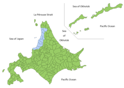
Rumoi Subprefecture (留萌振興局, Rumoi-shinkō-kyoku) is a subprefectureofHokkaido Prefecture, Japan. As of 2011, it had a population of 52,627 and an area of 4,019.97 square kilometres (1,552.12 sq mi). The population density of the subprefecture, 13 people per km2, is very low compared to the rest of Japan. The population of Rumoi Subprefecture represents 0.96% of the overall population of Hokkaido.[1][2]

Geography

[edit]

Rumoi Subprefecture stretches broadly across the coast of the Sea of Japan in northwestern Hokkaido.

Municipalities

[edit]
Name Area (km2) Population Pop. Density District Type Map
Rōmaji Kanji
Enbetsu 遠別町 590.86 2,966 5.02 Teshio District Town
Haboro 羽幌町 472.49 7,338 15.53 Tomamae District Town
Mashike 増毛町 369.64 4,634 12.54 Mashike District Town
Obira 小平町 627.29 3,277 5.22 Rumoi District Town
Rumoi (capital) 留萌市 297.44 22,242 74.78 no district City
Shosanbetsu 初山別村 280.04 1,249 4.46 Tomamae District Village
Teshio 天塩町 353.31 3,241 9.17 Teshio District Town
Tomamae 苫前町 454.5 3,261 7.17 Tomamae District Town

Mergers

[edit]

Rivers

[edit]

The Rumoi River 44 kilometres (27 mi) flows from Mount Poroshiri in the Hidaka Mountain range to the Sea of Japan.[3]

History

[edit]

Mashike Subprefecture was established as part of the administrative reforms of Hokkaido during the Meiji period (1868 – 1912). The capital was moved to Rumoi in 1914, and the subprefecture was renamed to Rumoi Subprefecture in the same year. Toyotomi Town) in Teshio District transferred to Sōya Subprefecture in 1948, and Horonobe was transferred to Sōya Subprefecture in 2010.

Economy

[edit]

The fishing industries dominates the economy of the area, and seafood processing remains a thriving industry.[2]

See also

[edit]

References

[edit]
  1. ^ 留萌の統計 [Statistics of Rumoi] (in Japanese). Rumoi, Hokkaido: Rumoi Subprefecture. 2012. Retrieved August 10, 2012.
  • ^ a b "Rumoi". Encyclopedia of Japan. Tokyo: Shogakukan. 2012. OCLC 56431036. Archived from the original on 2007-08-25. Retrieved 2012-08-08.
  • ^ "留萌川". Dijitaru Daijisen (in Japanese). Tokyo: Shogakukan. 2012. OCLC 56431036. Archived from the original on 2007-08-25. Retrieved 2012-08-10.
  • [edit]
    Retrieved from "https://en.wikipedia.org/w/index.php?title=Rumoi_Subprefecture&oldid=1218586547"

    Category: 
    Subprefectures in Hokkaido
    Hidden categories: 
    Pages using gadget WikiMiniAtlas
    CS1 uses Japanese-language script (ja)
    CS1 Japanese-language sources (ja)
    Articles with short description
    Short description is different from Wikidata
    Coordinates on Wikidata
    Articles with Japanese-language sources (ja)
    Articles containing Japanese-language text
    Official website different in Wikidata and Wikipedia


    This page was last edited on 12 April 2024, at 16:11 (UTC).

    Text is available under the Creative Commons Attribution-ShareAlike License 4.0; additional terms may apply. By using this site, you agree to the Terms of Use and Privacy Policy. Wikipedia® is a registered trademark of the Wikimedia Foundation, Inc., a non-profit organization.


    Privacy policy

    About Wikipedia

    Disclaimers

    Contact Wikipedia

    Code of Conduct

    Developers

    Statistics

    Cookie statement

    Mobile view


    Wikimedia Foundation
    Powered by MediaWiki