Jump to content


Main menu


Navigation  


Main page
Contents
Current events
Random article
About Wikipedia
Contact us
Donate


Contribute  


Help
Learn to edit
Community portal
Recent changes
Upload file


Search  


Create account

Log in


Create account
 Log in


Pages for logged out editors learn more  


Contributions
Talk


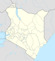
File:Kenya adm location map.svg


Page contents not supported in other languages.  


File
Talk


Read
View on Commons


Tools


Actions  


Read
View on Commons


General  


What links here
Upload file
Special pages
Printable version
Page information
Get shortened URL
Download QR code


Appearance


This is a file from the Wikimedia Commons

From Wikipedia, the free encyclopedia


File

File history

File usage

Global file usage

Metadata
File:Kenya adm location map.svg
Size of this PNG preview of this SVG file: 545 × 599 pixels. Other resolutions: 218 × 240 pixels | 437 × 480 pixels | 698 × 768 pixels | 931 × 1,024 pixels | 1,863 × 2,048 pixels | 945 × 1,039 pixels.

Original file(SVG file, nominally 945 × 1,039 pixels, file size: 295 KB)


Summary

Description
Deutsch: Positionskarte von Kenia
English: Location map of Kenya

Equirectangular projection, vertical stretching 100 %
Border coordinates

6
33←↕→43
-5
 Info This map is part of a series of location maps with unified standards: SVG as file format, standardised colours and name scheme. The boundaries on these maps always show the de facto situation and do not imply any endorsement or acceptance. In case of changes of the shown area the file is updated. The old version will be uploaded as a new file and thus is still available.
Date
Source

Own work using:

  • United States National Imagery and Mapping Agency data
  • World Data Base II data
Author NordNordWest
Kartenwerkstatt
This map has been made or improved in the German Kartenwerkstatt (Map Lab). You can propose maps to improve as well.

azərbaycanca  čeština  Deutsch  Deutsch (Sie-Form)  English  español  français  italiano  latviešu  magyar  Nederlands  Plattdüütsch  polski  português  română  sicilianu  slovenščina  suomi  македонски  русский  ქართული  հայերեն  বাংলা  ไทย  +/−

Licensing

Usage of this file with:

explanatory notes: Legally binding is only the full legalcode. For a free usage I recommend to respect the following licence conditions:
1. Provide my name as given above: NordNordWest,
2. a copy of, or the URI for, the applicable license: https://creativecommons.org/licenses/by-sa/3.0/de/legalcode,
3. the title of the work,
4. in the case of an adaptation, a credit identifying the use of the work in the adaptation.
This license and the rights granted hereunder will terminate automatically upon any breach by you of the terms of this license. Any of the above conditions can be waived if you get permission from the copyright holder. If you have questions or wish differing conditions, please contact me through nnwest@t-online.deormy discussion page

w:en:Creative Commons
attribution share alike
This file is licensed under the Creative Commons Attribution-Share Alike 3.0 Germany license.
Attribution: Karte: NordNordWest, Lizenz: Creative Commons by-sa-3.0 de
You are free:
  • to share – to copy, distribute and transmit the work
  • to remix – to adapt the work
  • Under the following conditions:
    • attribution – You must give appropriate credit, provide a link to the license, and indicate if changes were made. You may do so in any reasonable manner, but not in any way that suggests the licensor endorses you or your use.
    • share alike – If you remix, transform, or build upon the material, you must distribute your contributions under the same or compatible license as the original.

    Captions

    Location map of Kenya

    Items portrayed in this file

    depicts

    3 March 2015

    File history


    Click on a date/time to view the file as it appeared at that time.
    Date/TimeThumbnailDimensionsUserComment
    current21:39, 3 March 2015Thumbnail for version as of 21:39, 3 March 2015945 × 1,039 (295 KB)NordNordWest== {{int:filedesc}} == {{Information |Description= {{de|1=Positionskarte von Kenia}} {{en|1=Location map of Kenya}} {{Location map series N |stretching=100 |top=6 |bottom=-5 |left=33 |right=43 }} |Source={{Own using}} * United States National Imagery a...


    More than 100 pages use this file. The following list shows the first 100 pages that use this file only. A full list is available.

    2003 Cricket World Cup

    Africa Nazarene University

    Amboseli Airport

    Athi River (town)

    Baragoi

    Bomet

    Bungoma

    Bura, Taita-Taveta County

    Bura, Tana River County

    Busia, Kenya

    Butere

    Dadaab

    Diani Beach

    Eastleigh, Nairobi

    Eldama Ravine

    Eldoret

    Embakasi

    Garba Tula

    Garissa

    Hola, Kenya

    Hola massacre

    Homa Bay

    Isiolo

    Iten

    Jomo Kenyatta International Airport

    Kabarnet

    Kajiado

    Kakuma

    Kapsabet

    Kapthurin Formation

    Kariobangi

    Kenya national cricket team

    Kenyan Premier League

    Kiambu

    Kikuyu, Kenya

    Kilgoris

    Kilifi

    Kisii (city)

    Kisite-Mpunguti Marine National Park

    Kitale

    Kitengela

    Kitui

    Kutus

    Kwale

    Lamu

    Lamu Island

    Lang'ata

    Lavington, Nairobi

    Lewa Airport

    Liboi

    Limuru

    List of top-division football clubs in CAF countries

    Lodwar

    Loiyangalani

    Lokichogio

    Londiani

    Machakos

    Mado Gashi

    Malaba, Kenya

    Malindi

    Malindi Airport

    Manda Airport

    Mandera

    Mara Serena Airport

    Maralal

    Marsabit

    Meru, Kenya

    Metkei

    Moi Air Base

    Moi International Airport

    Molo, Kenya

    Mombasa County

    Mombasa Island

    Moyale

    Mpeketoni

    Mumias

    Naivasha

    Nakuru

    Namanga

    Nandi Hills, Kenya

    Nanyuki

    Nanyuki Airport

    Naro Moru

    Narok

    National Museums of Kenya

    Ngong, Kenya

    Nyeri

    Parklands, Nairobi

    Pate Island

    Ruiru

    Shimoni

    Suswa

    Tala, Kenya

    Taveta, Kenya

    Thika

    United Nations Office at Nairobi

    Vihiga

    Voi

    Wajir

    Westlands, Nairobi


    View more links to this file.

    Global file usage


    The following other wikis use this file:

    Usage on af.wikipedia.org

    Jomo Kenyatta Internasionale Lughawe

    Malindi

    Krieketwêreldbeker 2003

    Keniaanse nasionale krieketspan

    Vivienne-waterval

    Kampioenetrofee 2000


    Usage on an.wikipedia.org

    Nairobi

    Plantilla:Mapa de localización Kenya


    Usage on azb.wikipedia.org

    کیمانا

    هوما بی، کنیا

    نانیوکی، کنیا

    ماندرا، کنیا

    الدورت، کنیا

    کهانچا

    داداب

    مالیندی، کنیا

    باراقولی

    کیتوی

    ماچاکوس، کنیا

    تیکا، کنیا

    کاروری

    کیلیفی، کنیا

    ویهیقا

    مومیاس، کنیا

    کیتاله، کنیا

    قاریسا، کنیا

    لویانقالانی

    لودوار

    آیتن

    نایواشا، کنیا

    نقونق، کنیا

    ناکورو، کنیا

    بونقوما، کنیا

    امبو، کنیا

    بوسیا، کنیا

    واجیر، کنیا

    کیسومو، کنیا

    مومباسا

    مارسابیت

    ماکوتانو

    اجائو

    لوکیچار

    کاپدو

    بکنی

    ال جرا

    ایرانقی

    واما

    دبیدا

    آمبیرا

    کاررو


    View more global usage of this file.

    Metadata

    If the file has been modified from its original state, some details may not fully reflect the modified file.


    Retrieved from "https://en.wikipedia.org/wiki/File:Kenya_adm_location_map.svg"


    Privacy policy

    About Wikipedia

    Disclaimers

    Contact Wikipedia

    Code of Conduct

    Developers

    Statistics

    Cookie statement

    Mobile view


    Wikimedia Foundation
    Powered by MediaWiki