
This article has multiple issues. Please help improve it or discuss these issues on the talk page. (Learn how and when to remove these template messages)
|
Kisii
Getembe
| |
|---|---|

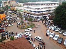
A roundabout in Kisii Town
| |
| Nickname:
Bosongo
| |
|
| |
| Coordinates: 0°41′S 34°46′E / 0.683°S 34.767°E / -0.683; 34.767 | |
| Country | Kenya |
| County | Kisii County |
| Sub-counties | Kisii Central, Kisii South & Kitutu Central |
| Area | |
| • Municipality | 70 km2 (30 sq mi) |
| Elevation | 1,700 m (5,577 ft) |
| Population
(2019)[1]
| |
| • Urban | 112,417 |
| Time zone | UTC+3 (EAT) |
| Area code | 058 |

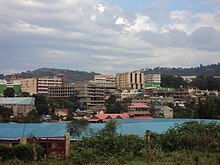
Kisii (also known as GetembeorBosongo) is a municipality and urban centre in south-western Kenya and the capital of Kisii County. Kisii Town also serves as a major urban and commercial centre in the Gusii Highlands—Kisii and Nyamira counties—and the South Nyanza region and is the second largest town in formerly greater Nyanza after Kisumu City. Kisii municipality sits right at the centre of the western Kenya tourist circuit that includes the Tabaka Soapstone Carvings, Maasai Mara, Ruma National Park and part of the Lake Victoria Basin.

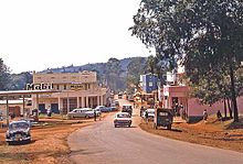
Kisii town was originally known by the Gusii people as Getembe. It was later named Bosongo, it originated from 'Abasongo' (to refer to the British or Whites) who lived in the town during the colonial times. The town was originally established by British soldiers who were being forced to retreat from Lake Victoria by heavy gunfire from German soldiers' gunboats during the Great War in the early 20th century.[2] Later Kisii was chosen to be the District Headquarters of the larger South Nyanza and Kisii region.[citation needed]
The town is predominantly inhabited by the Gusii community (also known as the Kisii). The Nubians, Arabs, Luo, Luhya, Kuria, Kikuyu, Kamba, Somali, Asian and Kalenjin make up a minority of residents.
As of 2019[update], Kisii town in its location of Kisii Central had a population of 13,422, with 6,839 male and 6,583 female, and a population density of 4,011/km2 in an area of 3.3 km2.[1] It is the second most populous town in terms of population density in Nyanza region after Kisumu. The population of the town grew rapidly after the 2007–08 post-election violence. The growth was due to the consideration that the town experienced peace becoming the hub for all communities in the country.[3]
Among Kenya's urban areas, Kisii municipality has a relatively high population density owing to the scarcity of land in the municipality boundaries spurring further expansion of settlement in the outlying area. These alternative settlements have been sanctioned by the municipal government which, in turn, has allowed residents to develop their homes just outside the municipality boundary to alleviate this phenomenon.[4]

The economy of Kisii town is derived from commerce and agriculture. Crops and fruit cultivated around the area include maize, managu, beans, bananas, pineapples, avocados, pawpaws etc. Cash crops in this area within and outside the municipality include coffee and tea which have been in existence before independence. Coffee processing within the municipality is carried out. Kisii is the fastest growing town in western Kenya thanks mainly to its high population, political stability and general tranquility.[citation needed]
Smaller components are in food processing, health care, education. Although it has are few industrial activities, it has potential for larger agro-based industries due to its location in a rich agricultural area. Soapstone quarrying takes place near the town around Tabaka, southwest of the town and a few kilometres off the Kisii-Isebania Road. Coca-Cola has a bottling and distribution plant in Kisii municipality until recently when it was closed. The town hosts large supermarket chain stores, e.g., Uchumi, Nakumatt and Tuskys which have been closed Naivas and Quick mart. It also hosts 19 commercial banking and financial institutions' branches. These include the long-existing: Kenya Commercial Bank (KCB), Absa Bank, National Bank, Post Bank, and Co-operative Bank (two branches). Newer entrants in the banking sector such as Equity Bank, I&M Bank, CFC Stanbic, Credit Bank, Kenya Women Finance Trust, Family Bank, Chase Bank, Eco-Bank, Diamond Trust Bank, K-Rep Bank and others have launched new branches taking advantage of the large population and the positioning of Kisii as an increasing commercial hub town. Mwalimu Cooperative Savings & Credit Society Limited (Mwalimu Sacco), the largest Sacco in Kenya, maintains a branch in Kisii. Due to more cash flow the central bank of Kenya has set an exchange center to serve the larger south nyanza region and some parts of Central rift. Moreover, like many of Kenya's major urban centres, there is an influx of numerous other business ventures such as the hospitality sector with hotels, bars, restaurants, sports pubs, among other commercial activities.
The Kisii County Government runs the town, headed by the governor. The county government headquarters are located in the town. The town hosts Law Courts, Ministry offices, State Law Office branch, among other governmental installations.

Kisii is located in western Kenya, on latitude: 0° 41' 0 S and longitude: 34° 46' 0 E. The town is a driving distance of 309 km (192 mi) from the capital city of Nairobi, located east-southeast, on Class B3 all-weather road. Other major urban centre's distances from Kisii town are Kisumu City which is 114 km (71 mi) to the northwest; Nyamira at 23 km (14 mi) to the immediate north; Keroka at 25 km (16 mi) to the east; Kericho at 101 km (63 mi) to the northeast; Kilgoris at 46 km (29 mi) to the southeast; Narok at 165 km (103 mi) to the east; and Migori to the south-west 67 km (42 mi) which otherwise connects the town to the Kenya /Tanzania border at Isebania town a further 31 km (19 mi) south.
Public transportation, which is operated privately, is available throughout the town. A good example is private-owned taxis (matatus), taxi cabs and 'boda-boda' (motorcycle taxis) as an alternative to privately owned vehicles. Kisii town has one of the most organized bus stations and public transport systems in the country. Buses and matatus are not allowed inside the town.
Air service to Kisii is minimal. However, chartered flights mainly from Nairobi's Wilson Airport transport passengers to Kisii's Suneka Airstrip situated 9 km (6 mi) southwest of the town centre. The facility is underused, but many of the residents especially businessmen, local politicians, and tourists use it for convenience.
From Kisii, it is easy to get to Tabaka Soapstone quarries, the Maasai Mara Game Reserve in Narok County, Lambwe Valley Game Reserve in Homa Bay County, Kisumu, Lake Victoria, and the Kenya/Tanzania or Kenya/Uganda border points.
Kisii town enjoys a Tropical highland climate. Temperature vary from lows of 52F July to highs of 79F January, annually . It generally receives rain all year round thanks to its positioning in the Lake Victoria lake basin and the heavily foliaged Kisii highlands. Due to its unique positioning within hills, Kisii town has never experienced flooding.
The city frequently receives thunderstorms, and some thirty people in Kisii die each year from lightning strikes because of their frequency and because many of the area's structures have metal roofs.[5]

Soapstone carving is the predominant craft in Kisii. Kisii town is home to the best soapstone carvers in the continent. Their products are very popular in Europe and USA. Kisii is a favourite stopover for tourists who want a taste of the exquisite Kisii carvings. Kisii town is also the venue for the annually held Gusii Cultural Festival, an event focusing on the cultural heritage of the Gusii community.

Football (soccer) of Kenya Premier League status is played at Gusii Stadium and other surrounding grounds. Shabana Football Club is based in Kisii town; it has been a popular soccer club in Gusiiland and has featured in the Kenya national premier league for many years. Formed by V. Dogo Khan, the proprietor of Shabana Hardware Stores as an incentive to his store employees in the mid-1980s, it grew to be a strong football team which in its successful run, attracted and recruited star players from local high schools and talented individual players living or working in the municipality. However, its team performance has lately be relegated down to national 2nd Division league after losing most of its star players to other local and international teams for economic reasons.
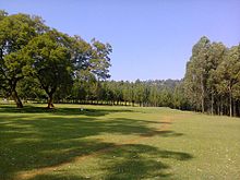
Track sports such as athletics meetings are popular with the town's residents and Gusiiland in general. Such meetings are held during schools' and colleges' sports season in mid year. Other sports in town include volleyball, basketball and netball which attract a diverse participation. Gusii Stadium has been a popular venue for these meetings for many years. Lastly, golf is mainly played by middle- or upper-income residents who are members of the Kisii Golf & Sports Club, a private members' club in the municipality. This trend is one of the remnants of a tradition that was borrowed from former British settlers by the emerging Kenyan Africa-educated and elite. Many towns in the nation host vast golf courses; Kisii is one of them.

A portion of larger Kisii Golf Club's course was open for public recreation by the local authority for a couple of years. This area was later consolidated back to the golf course. Immediate availability of land for commercial or residential development has been the greatest challenge facing its longtime residents and potential investors. Lately,[when?] this impediment has been addressed by the local authority.
Kisii Golf has experienced major challenges from encroachment through illegal farming activities. The area has since been fenced to control public encroachment. As a result, the area has improved and further developed into a bird sanctuary..
The Kisii Sports Club which claims to have responsibility of managing the golf has put up adequate and viable legislation to govern the green space. Enabling the development of local sport talent and often doubling up as a helipad for visitors.
This article's use of external links may not follow Wikipedia's policies or guidelines. Please improve this article by removing excessiveorinappropriate external links, and converting useful links where appropriate into footnote references. (January 2016) (Learn how and when to remove this message)
|
| International |
|
|---|---|
| National |
|
0°41′S 34°46′E / 0.683°S 34.767°E / -0.683; 34.767