Jump to content


Main menu


Navigation  


Main page
Contents
Current events
Random article
About Wikipedia
Contact us
Donate


Contribute  


Help
Learn to edit
Community portal
Recent changes
Upload file


Search  


Create account

Log in


Create account
 Log in


Pages for logged out editors learn more  


Contributions
Talk


File:Las Palmas-Loc.svg


Page contents not supported in other languages.  


File
Talk


Read
View on Commons


Tools


Actions  


Read
View on Commons


General  


What links here
Upload file
Special pages
Printable version
Page information
Get shortened URL
Download QR code


Appearance


This is a file from the Wikimedia Commons

From Wikipedia, the free encyclopedia


File

File history

File usage

Global file usage

Metadata
File:Las Palmas-Loc.svg
Size of this PNG preview of this SVG file: 512 × 453 pixels. Other resolutions: 271 × 240 pixels | 543 × 480 pixels | 868 × 768 pixels | 1,157 × 1,024 pixels | 2,315 × 2,048 pixels.

Original file(SVG file, nominally 512 × 453 pixels, file size: 95 KB)


Summary

Description
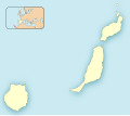
English: Location map of Province of Las Palmas

Equirectangular projection, N/S stretching 130 %. Geographic limits of the map:

  • N: 29.473259° N
  • S: 27.685818° N
  • W: 15.927961° O
  • E: 13.281935 ° O
Español: Mapa de localización de las Provincia de Las Palmas

Proyección equirrectangular (cilíndrica equidistante), N/S estirada 130 %. Límites geográficos del mapa:

  • N: 29.473259° N
  • S: 27.685818° N
  • W: 15.927961° O
  • E: 13.281935 ° O
Date
Source Own work based on: EspañaLoc.svg by HansenBCN
Author Miguillen
SVG development

InfoField

 
The SVG code is valid.
 
This locator map was created with Inkscape.

This map has been made or improved in the Spanish Taller de Cartografía (Map Lab). You can propose maps to improve as well.

aragonés | català | Deutsch | English | español | euskara | français | galego | magyar | italiano | Nederlands | português | русский | sicilianu | +/−

Licensing

Miguillen, the copyright holder of this work, hereby publishes it under the following license:
w:en:Creative Commons
attribution share alike
This file is licensed under the Creative Commons Attribution-Share Alike 3.0 Unported license.
Attribution: Miguillen
You are free:
  • to share – to copy, distribute and transmit the work
  • to remix – to adapt the work
  • Under the following conditions:
    • attribution – You must give appropriate credit, provide a link to the license, and indicate if changes were made. You may do so in any reasonable manner, but not in any way that suggests the licensor endorses you or your use.
    • share alike – If you remix, transform, or build upon the material, you must distribute your contributions under the same or compatible license as the original.

    Captions

    Add a one-line explanation of what this file represents

    Items portrayed in this file

    depicts

    some value

    author name string: Miguillen

    21 November 2010

    image/svg+xml

    File history


    Click on a date/time to view the file as it appeared at that time.
    Date/TimeThumbnailDimensionsUserComment
    current17:03, 28 July 2020Thumbnail for version as of 17:03, 28 July 2020512 × 453 (95 KB)Pedro alfred2Reverted to version as of 15:34, 21 November 2010 (UTC)
    16:15, 10 December 2010Thumbnail for version as of 16:15, 10 December 2010512 × 453 (53 KB)Miguillenmosca con CCAA según convención
    15:34, 21 November 2010Thumbnail for version as of 15:34, 21 November 2010512 × 453 (95 KB)Miguillenestiro un 130 %
    12:10, 21 November 2010Thumbnail for version as of 12:10, 21 November 2010512 × 362 (96 KB)Miguillen== {{int:filedesc}} == {{Information |Description={{en|Location map of Province of Las Palmas}} Equirectangular projection, N/S stretching 130 %. Geographic limits of the map: * N: ° N * S: ° N * W: ° O * E: ° O {{e


    The following pages on the English Wikipedia use this file (pages on other projects are not listed):

    202425 Tercera Federación

    Agaete

    Agüimes

    Alegranza

    Antigua, Fuerteventura

    Artenara

    Arucas, Las Palmas

    Betancuria

    Firgas

    Graciosa, Canary Islands

    Gáldar

    Haría (municipality)

    Ingenio, Las Palmas

    La Aldea de San Nicolás

    La Bocayna

    La Oliva

    Mogán

    Montaña Clara

    Moya, Las Palmas

    Palacete Rodriguez Quegles

    Pájara

    Roque del Este

    Roque del Oeste

    San Bartolomé, Las Palmas

    San Bartolomé de Tirajana

    Santa Brígida, Las Palmas

    Santa Lucía de Tirajana

    Santa María de Guía de Gran Canaria

    Segunda División B de Futsal

    Teguise (municipality)

    Tejeda

    Teror

    Tinajo (municipality)

    Tuineje

    Tías, Las Palmas

    Valleseco

    Valsequillo de Gran Canaria

    Vega de San Mateo

    Yaiza (municipality)

    User:Shazertom/La Graciosa

    Module:Location map/data/Spain Province of Las Palmas

    Module:Location map/data/Spain Province of Las Palmas/doc


    Global file usage


    The following other wikis use this file:

    Usage on ar.wikipedia.org

    سانتا لوثيا دي تيراخانا

    سان بارتولومي دي تيراخانا

    أروكاس

    بويرتو ديل روساريو

    إنخينيو

    أغويميس

    غالدار

    موغان

    لا أوليفا

    باخارا

    تيغيسي

    تياس (لاس بالماس)

    سانتا بريخيدا

    سان بارتولومي (لاس بالماس)

    يايثا (لاس بالماس)

    سانتا ماريا دي غيا دي غران كناريا

    توينيخي

    تيرور (لاس بالماس)

    أنتيغوا (لاس بالماس)

    فالسيكيو دي غران كناريا

    لا ألديا دي سان نيكولاس

    مويا (لاس بالماس)

    فيغا دي سان ماتيو

    فيرغاس

    أغايتي

    تيناخو

    أريا (لاس بالماس)

    فاييسيكو

    تيخيدا

    أرتينارا

    بيتانكوريا

    قالب:Location map Spain Province of Las Palmas


    Usage on ba.wikipedia.org

    Ҡалып:ПозКарта Испания Канар утрауҙары Лас-Пальмас


    Usage on ceb.wikipedia.org

    Plantilya:Location map Spain Province of Las Palmas

    San Bartolomé (munisipyo)


    Usage on el.wikipedia.org

    Λας Πάλμας ντε Γκραν Κανάρια


    Usage on es.wikipedia.org

    Las Palmas de Gran Canaria

    Arrecife (España)

    Haría

    San Bartolomé (Lanzarote)

    Teguise

    Tías (Las Palmas)

    Tinajo

    Yaiza

    Antigua (Fuerteventura)

    Betancuria

    La Oliva

    Pájara

    Puerto del Rosario

    Tuineje


    View more global usage of this file.

    Metadata

    If the file has been modified from its original state, some details may not fully reflect the modified file.


    Retrieved from "https://en.wikipedia.org/wiki/File:Las_Palmas-Loc.svg"


    Privacy policy

    About Wikipedia

    Disclaimers

    Contact Wikipedia

    Code of Conduct

    Developers

    Statistics

    Cookie statement

    Mobile view


    Wikimedia Foundation
    Powered by MediaWiki