Jump to content


Main menu


Navigation  


Main page
Contents
Current events
Random article
About Wikipedia
Contact us
Donate


Contribute  


Help
Learn to edit
Community portal
Recent changes
Upload file


Search  


Create account

Log in


Create account
 Log in


Pages for logged out editors learn more  


Contributions
Talk


Contents


(Top)


1 Geography  


2 Communities  


3 Sites of interest  


4 See also  


5 References  


Haría (municipality)


العربية
Aragonés
Asturianu
Català
Cebuano
Deutsch
Español
Esperanto
Euskara
Français
Galego
Interlingua
Italiano

Ladin
Latina
Lombard
Magyar
مصرى
Bahasa Melayu
Nederlands
Нохчийн
Nordfriisk
Occitan
Oʻzbekcha / ўзбекча
Polski
Português
Русский
Shqip
Svenska
Татарча / tatarça
Українська
Vèneto
Winaray


Edit links


Article
Talk


Read
Edit
View history


Tools


Actions  


Read
Edit
View history


General  


What links here
Related changes
Upload file
Special pages
Permanent link
Page information
Cite this page
Get shortened URL
Download QR code
Wikidata item


Print/export  


Download as PDF
Printable version


In other projects  


Wikimedia Commons
Wikivoyage


Appearance


Coordinates: 29°9N 13°30W / 29.150°N 13.500°W / 29.150; -13.500
 

From Wikipedia, the free encyclopedia


Haría
View of Haría
View of Haría
Flag of Haría
Official seal of Haría
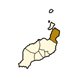
Municipal location in Lanzarote
Haría is located in Province of Las Palmas
Haría

Haría

Location in the province of Las Palmas

Haría is located in Canary Islands
Haría

Haría

Haría (Canary Islands)

Haría is located in Spain, Canary Islands
Haría

Haría

Haría (Spain, Canary Islands)

Coordinates: 29°9′N 13°30′W / 29.150°N 13.500°W / 29.150; -13.500
CountrySpain
Autonomous communityCanary Islands
ProvinceLas Palmas
IslandLanzarote
Area
 • Total106.59 km2 (41.15 sq mi)
Population
 (2018)[2]
 • Total4,969
 • Density47/km2 (120/sq mi)

Haría is a municipality on the island of Lanzarote in the Canary Islands, the northernmost and easternmost Canarian municipality. Surrounded on three sides by the Atlantic Ocean, the municipality is bordered to the south by the municipality of Teguise. It forms part of Las Palmas Province. The seat of the municipality is the town of Haría. The population of the municipality was 4,872 in 2013.[3] The total land area of the municipality is 106.59 square kilometres (41.15 sq mi).[1]

Geography[edit]

The west of the municipality is largely mountainous, with much of the western coastline rising steeply a little way inland. Numerous miradors (viewpoints) on this high ground offer views of the island, with the most well known being the Mirador del Río which is a popular tourist attraction.[citation needed] To the southeast the land is low-lying and largely used for agriculture, with many small beach resorts along the coast. The northeast of the municipality is largely uninhabited, having been buried approximately 3000 years ago by the eruption of the Montaña Corona which formed the inhospitable Malpais de la Corona. This eruption also produced extensive hollow lava tunnels called jameos, some of which have been developed into two of the island's most-visited[citation needed] geological attractions: the Cueva de los Verdes and the Jameos del Agua.

Communities[edit]

Sites of interest[edit]

See also[edit]

References[edit]

  • ^ Municipal Register of Spain 2018. National Statistics Institute.
  • ^ Instituto Canario de Estadística Archived 2014-04-18 at the Wayback Machine, population

  • Retrieved from "https://en.wikipedia.org/w/index.php?title=Haría_(municipality)&oldid=1019894375"

    Category: 
    Municipalities in Lanzarote
    Hidden categories: 
    Pages using gadget WikiMiniAtlas
    Webarchive template wayback links
    Articles with short description
    Short description is different from Wikidata
    Coordinates on Wikidata
    All articles with unsourced statements
    Articles with unsourced statements from November 2017
    Articles with unsourced statements from April 2014
    Articles with VIAF identifiers
    Articles with GND identifiers


    This page was last edited on 26 April 2021, at 01:13 (UTC).

    Text is available under the Creative Commons Attribution-ShareAlike License 4.0; additional terms may apply. By using this site, you agree to the Terms of Use and Privacy Policy. Wikipedia® is a registered trademark of the Wikimedia Foundation, Inc., a non-profit organization.


    Privacy policy

    About Wikipedia

    Disclaimers

    Contact Wikipedia

    Code of Conduct

    Developers

    Statistics

    Cookie statement

    Mobile view


    Wikimedia Foundation
    Powered by MediaWiki