Jump to content


Main menu


Navigation  


Main page
Contents
Current events
Random article
About Wikipedia
Contact us
Donate


Contribute  


Help
Learn to edit
Community portal
Recent changes
Upload file


Search  


Create account

Log in


Create account
 Log in


Pages for logged out editors learn more  


Contributions
Talk


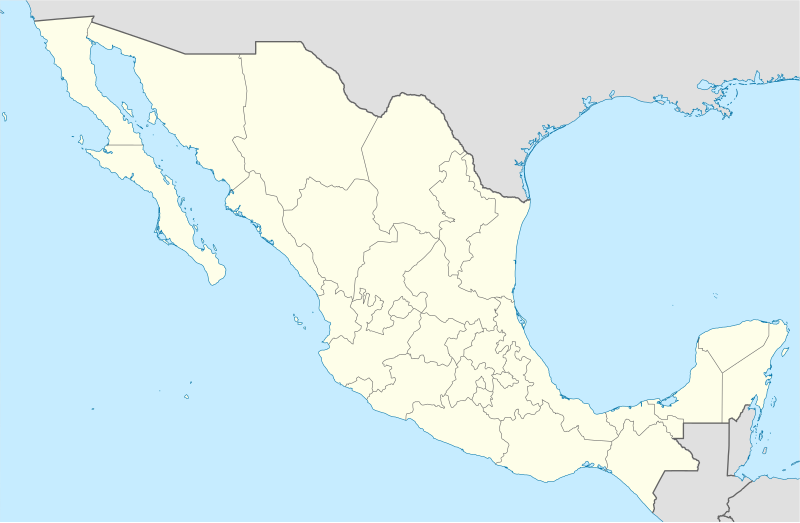
File:Mexico States blank map.svg


Page contents not supported in other languages.  


File
Talk


Read
View on Commons


Tools


Actions  


Read
View on Commons


General  


What links here
Upload file
Special pages
Printable version
Page information
Get shortened URL
Download QR code


Appearance


This is a file from the Wikimedia Commons

From Wikipedia, the free encyclopedia


File

File history

File usage

Global file usage

Metadata
File:Mexico States blank map.svg
Size of this PNG preview of this SVG file: 800 × 523 pixels. Other resolutions: 320 × 209 pixels | 640 × 418 pixels | 1,024 × 669 pixels | 1,280 × 837 pixels | 2,560 × 1,673 pixels | 2,029 × 1,326 pixels.

Original file(SVG file, nominally 2,029 × 1,326 pixels, file size: 473 KB)


Yolot hdz

Summary

Description
English: Map of Mexico, with states borders.
Español: Mapa de Mexico, con los límites de los estados.
Français : Carte du Mexique, avec les limites des États.
Date
Source Image:Mexico blank.svgbyYavidaxiu under licence GFDL.
Author Sémhur
Other versions

Derivative works of this file:

Camera location23° 36′ 00″ N, 102° 30′ 00″ W  Heading=0° Kartographer map based on OpenStreetMap.View this and other nearby images on: OpenStreetMapinfo
 
W3C-validity not checked.
 
This W3C-unspecified vector image was created with Inkscape .

Licensing

I, the copyright holder of this work, hereby publish it under the following licenses:
Licence Art Libre Copyleft: This work of art is free; you can redistribute it and/or modify it according to terms of the Free Art License. You will find a specimen of this license on the Copyleft Attitude site as well as on other sites.
w:en:Creative Commons
attribution share alike
This file is licensed under the Creative Commons Attribution-Share Alike Attribution-Share Alike 4.0 International, 3.0 Unported, 2.5 Generic, 2.0 Generic and 1.0 Generic license.
You are free:
  • to share – to copy, distribute and transmit the work
  • to remix – to adapt the work
  • Under the following conditions:
    • attribution – You must give appropriate credit, provide a link to the license, and indicate if changes were made. You may do so in any reasonable manner, but not in any way that suggests the licensor endorses you or your use.
    • share alike – If you remix, transform, or build upon the material, you must distribute your contributions under the same or compatible license as the original.
    You may select the license of your choice.

    Captions

    Map of Mexico, with states borders.

    Items portrayed in this file

    depicts

    some value

    24 September 2008

    23°36'N, 102°30'W

    heading: 0 degree

    File history


    Click on a date/time to view the file as it appeared at that time.
    Date/TimeThumbnailDimensionsUserComment
    current15:41, 13 August 2010Thumbnail for version as of 15:41, 13 August 20102,029 × 1,326 (473 KB)KmusserTry that again
    15:41, 13 August 2010Thumbnail for version as of 15:41, 13 August 2010975 × 654 (361 KB)Kmusserchange projection to match that used at File:Mexico location map.svg so should be more accurate for pushpins, also reverted Yucatan boundary change to match Mexican government maps.
    11:58, 25 May 2009Thumbnail for version as of 11:58, 25 May 2009975 × 654 (361 KB)SémhurModify border south between Quintana Roo and Campeche
    08:31, 24 May 2009Thumbnail for version as of 08:31, 24 May 2009975 × 654 (361 KB)SémhurAdding Yucatan states
    12:57, 24 September 2008Thumbnail for version as of 12:57, 24 September 2008975 × 654 (330 KB)Sémhurnew try
    12:40, 24 September 2008Thumbnail for version as of 12:40, 24 September 2008975 × 654 (328 KB)SémhurThiner strokes
    12:37, 24 September 2008Thumbnail for version as of 12:37, 24 September 2008975 × 654 (328 KB)Sémhur{{Information |Description= {{en|Map of Mexico, with states borders.}} {{es|Mapa de Mexico, con los límites de los estados.}} {{fr|Carte du Mexique, avec les limites des états.}} |Source=Travail personnel / Own work. Source : * [[:Image:Mexico blank.sv


    More than 100 pages use this file. The following list shows the first 100 pages that use this file only. A full list is available.

    1970 FIFA World Cup

    1986 FIFA World Cup

    Acapulco

    Acapulco International Airport

    Acteal massacre

    Agua Prieta

    Amecameca

    Benito Juárez Municipality, Quintana Roo

    Boca del Río, Veracruz

    Bolonchén, Campeche

    Campeche (city)

    Cancún

    Celaya

    Celestún

    Champotón, Campeche

    Chapultepec

    Chetumal

    Chicxulub crater

    Chihuahua City

    Chilpancingo

    Cholula, Puebla

    Ciudad Acuña

    Ciudad Juárez

    Ciudad Madero

    Ciudad Victoria

    Ciudad del Carmen

    Coatepec, Veracruz

    Coatepec Harinas

    Colima (city)

    Comitán

    Copper Canyon

    Cuernavaca

    Culiacán

    Córdoba, Veracruz

    Dolores Hidalgo

    Durango (city)

    Dzitbalché

    Escárcega

    Felipe Carrillo Puerto, Quintana Roo

    Fortín de las Flores

    Guadalajara

    Guadalajara International Airport

    Guanajuato (city)

    Gómez Palacio, Durango

    Hermosillo

    Heroica Nogales

    Lerdo, Durango

    León, Guanajuato

    Malinalco

    Manzanillo, Colima

    Maní, Yucatán

    Matamoros, Tamaulipas

    Mexicali

    Mexico City International Airport

    Mitla

    Monterrey

    Morelia

    Motul, Yucatán

    Mérida, Yucatán

    Naolinco

    Nogales Municipality, Veracruz

    Oaxaca City

    Oxkutzcab Municipality

    Papantla

    Parral, Chihuahua

    Perote, Veracruz

    Piedras Negras, Coahuila

    Playa del Carmen

    Progreso, Yucatán

    Puebla (city)

    Puerto Morelos

    Puerto Vallarta

    Querétaro (city)

    RenoTahoe International Airport

    Reynosa

    San Cristóbal de las Casas

    San Diego International Airport

    San Francisco Bay Oakland International Airport

    San Jose International Airport

    San Luis Potosí (city)

    San Pablo Guelatao

    Solidaridad Municipality

    Tampico

    Tapachula

    Taxco

    Tecomán

    Tekax

    Teotihuacan

    Tijuana

    Tijuana International Airport

    Tlacotalpan

    Tlaxcala (city)

    Torreón

    Tula de Allende

    Tulum

    Tuxtla Gutiérrez

    Valladolid, Yucatán

    Valley International Airport

    Villahermosa

    Xalapa


    View more links to this file.

    Global file usage


    The following other wikis use this file:

    Usage on af.wikipedia.org

    FIFA Sokker-Wêreldbekertoernooi in 1986

    FIFA Sokker-Wêreldbekertoernooi in 1970

    FIFA Sokker-Konfederasiebeker in 1999

    FIFA Sokker-Wêreldbekertoernooi in 2026

    Toluca

    Meksikostad Internasionale Lughawe


    Usage on am.wikipedia.org


    :Location map 

    :Location map/doc


    Usage on ar.wikipedia.org

    كأس العالم 1986

    قالب:خريطة مواقع المكسيك

    الدوري المكسيكي الممتاز

    مطار سان خوسيه الدولي

    مطار رينو تاهو الدولي

    ويكيبيديا:ورشة الصور/أرشيف 9

    الاختطاف الجماعي بإجوالا (2014)

    نقاش المستخدمة:ولاء/IX

    قائمة مواقع التراث العالمي في المكسيك


    Usage on ast.wikipedia.org

    Aeropuertu Internacional de Ciudá de Méxicu

    Aeropuertu Internacional General Juan N. Álvarez

    Aeropuertu Internacional de Puebla


    Usage on azb.wikipedia.org

    شابلون:Location map

    شابلون:Location map/بلگه

    شابلون:Location map Mexico

    آلتار، سونورا

    نوقئیلس، سونورا

    توبوتاما

    قوایماس

    هرموزیلو

    سان لوئیس ریو کولورادو


    Usage on ban.wikipedia.org

    Piala Jagat FIFA 1970

    Piala Jagat FIFA 1986


    Usage on bcl.wikipedia.org

    Teuchitlan


    Usage on bn.wikipedia.org

    : ি ি

     ি ি

    ি ি ি  ি

    ি: ি//ি

    ি: ি//ি/ি


      ি িি


    ি 

     ি 


    Usage on bs.wikipedia.org

    Svjetsko prvenstvo u nogometu 1986.

    Svjetsko prvenstvo u nogometu 1970.

    Šablon:Lokacijska karta Meksiko

    Šablon:Lokacije stadiona FIFA SP 1970.


    Usage on ca.wikipedia.org

    Batalla de Puebla

    Copa del Món de Futbol de 1970


    View more global usage of this file.

    Metadata

    If the file has been modified from its original state, some details may not fully reflect the modified file.


    Retrieved from "https://en.wikipedia.org/wiki/File:Mexico_States_blank_map.svg"


    Privacy policy

    About Wikipedia

    Disclaimers

    Contact Wikipedia

    Code of Conduct

    Developers

    Statistics

    Cookie statement

    Mobile view


    Wikimedia Foundation
    Powered by MediaWiki