Jump to content


Main menu


Navigation  


Main page
Contents
Current events
Random article
About Wikipedia
Contact us
Donate


Contribute  


Help
Learn to edit
Community portal
Recent changes
Upload file


Search  


Create account

Log in


Create account
 Log in


Pages for logged out editors learn more  


Contributions
Talk


File:Philippines location map (square).svg


Page contents not supported in other languages.  


File
Talk


Read
View on Commons


Tools


Actions  


Read
View on Commons


General  


What links here
Upload file
Special pages
Printable version
Page information
Get shortened URL
Download QR code


Appearance


This is a file from the Wikimedia Commons

From Wikipedia, the free encyclopedia


File

File history

File usage

Global file usage

Metadata
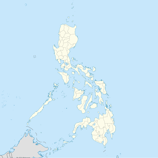
File:Philippines location map (square).svg
Size of this PNG preview of this SVG file: 600 × 600 pixels. Other resolutions: 240 × 240 pixels | 480 × 480 pixels | 768 × 768 pixels | 1,024 × 1,024 pixels | 2,048 × 2,048 pixels | 1,332 × 1,332 pixels.

Original file(SVG file, nominally 1,332 × 1,332 pixels, file size: 1.49 MB)


Summary

Description
English: Location map of the Philippines

Equirectangular projection based on the parallel of 10°43' N

  • N: 21.2° N
  • S: 4.3° N
  • W: 114.0° E
  • E: 131.2° E
Date
Source Own work
Author Hellerick
SVG development

InfoField

 
The SVG code is valid.
 
This map was created with Inkscape.

Licensing

I, the copyright holder of this work, hereby publish it under the following license:
w:en:Creative Commons
attribution share alike
This file is licensed under the Creative Commons Attribution-Share Alike 3.0 Unported license.
You are free:
  • to share – to copy, distribute and transmit the work
  • to remix – to adapt the work
  • Under the following conditions:
    • attribution – You must give appropriate credit, provide a link to the license, and indicate if changes were made. You may do so in any reasonable manner, but not in any way that suggests the licensor endorses you or your use.
    • share alike – If you remix, transform, or build upon the material, you must distribute your contributions under the same or compatible license as the original.

    Captions

    Map of the Philippines Islands (P.I.)

    Items portrayed in this file

    depicts

    some value

    17 June 2013

    image/svg+xml

    File history


    Click on a date/time to view the file as it appeared at that time.
    (newest | oldest) View (newer 10 | ) (10 | 20| 50| 100 | 250 | 500)
    Date/TimeThumbnailDimensionsUserComment
    current10:17, 19 August 2021Thumbnail for version as of 10:17, 19 August 20211,332 × 1,332 (1.49 MB)AichiWikiFixerUpdated boundaries
    07:53, 18 June 2021Thumbnail for version as of 07:53, 18 June 20211,332 × 1,332 (2.24 MB)AichiWikiFixerMap update.
    03:55, 18 June 2021Thumbnail for version as of 03:55, 18 June 20211,332 × 1,332 (2.23 MB)AichiWikiFixerSmall changes.
    03:49, 18 June 2021Thumbnail for version as of 03:49, 18 June 20211,332 × 1,332 (2.23 MB)AichiWikiFixerExternal changes for boundaries and coastlines.
    13:11, 17 June 2021Thumbnail for version as of 13:11, 17 June 20211,332 × 1,332 (2.23 MB)AichiWikiFixerAdditional islands, lakes, and updated coastlines.
    10:34, 17 June 2021Thumbnail for version as of 10:34, 17 June 20211,332 × 1,332 (2.23 MB)AichiWikiFixerUpdate boundaries.
    02:04, 25 May 2021Thumbnail for version as of 02:04, 25 May 20211,332 × 1,332 (2.22 MB)HueMan1Reverted to version as of 07:24, 7 September 2020 (UTC)
    07:11, 17 May 2021Thumbnail for version as of 07:11, 17 May 20211,332 × 1,332 (3.72 MB)PetrioloReverted to version as of 05:36, 3 May 2021 (UTC) The new administrative borders are based from the Philippine government websites (https://www.geoportal.gov.ph/; http://noah.up.edu.ph/), and is deemed accurate. These new files have reliable sources and there's no "beauty" in it if it is inaccurate in the first place.
    14:00, 16 May 2021Thumbnail for version as of 14:00, 16 May 20211,332 × 1,332 (2.22 MB)AichiWikiFixerReverted to version as of 07:24, 7 September 2020 (UTC) (Borders seen as ugly)
    05:36, 3 May 2021Thumbnail for version as of 05:36, 3 May 20211,332 × 1,332 (3.72 MB)Petrioloupdated with NAMRIA borders

    (newest | oldest) View (newer 10 | ) (10 | 20| 50| 100 | 250 | 500)


    More than 100 pages use this file. The following list shows the first 100 pages that use this file only. A full list is available.

    Abuyog

    Alangalang

    Albuera, Leyte

    Alcoy, Cebu

    Antipolo

    Aparri

    Aringay

    Ateneo de Manila University

    Ayala Center

    Babatngon

    Bacolod

    Bacoor

    Baguio

    Balanga, Bataan

    Balangiga

    Baler, Aurora

    Barili

    Basco, Batanes

    Batangas City

    Battle of Tirad Pass

    Busuanga, Palawan

    Calamba, Laguna

    Calatagan

    Caloocan

    Camp John Hay

    Candaba

    Candelaria, Quezon

    Cavinti

    Cavite City

    Cebu City

    Cities of the Philippines

    Clark Air Base

    Coron, Palawan

    Cotabato City

    Dasmariñas

    Davao City

    De La Salle University

    Del Monte Airfield

    Digos

    Dipolog

    Dumaguete

    El Nido, Palawan

    General Santos

    Geography of the Philippines

    Gingoog

    History of the Philippines

    Iligan

    Isabela, Basilan

    Lakewood, Zamboanga del Sur

    Lapu-Lapu City

    Las Piñas

    Legazpi, Albay

    Legazpi Airport

    List of cities in the Philippines

    Los Baños, Laguna

    Lubao

    Mabitac

    Makati

    Malabon

    Malacañang Palace

    Malaybalay

    Malinao, Aklan

    Mandaluyong

    Mandaue

    Manila

    Mansalay

    Marikina

    Meycauayan

    Miagao

    Muntinlupa

    Navotas

    Nielson Field

    Ninoy Aquino International Airport

    Ormoc

    Pagbilao

    Parañaque

    Pasay

    Pasig

    Pateros

    Pinamalayan

    Puerto Galera

    Quezon City

    Rodriguez, Rizal

    San Antonio, Zambales

    San Fernando, La Union

    San Isidro, Davao Oriental

    San Jose del Monte

    San Juan, Metro Manila

    San Leonardo, Nueva Ecija

    San Pablo, Laguna

    San Pedro, Laguna

    Santa Rosa, Laguna

    Santo Domingo, Nueva Ecija

    Sorsogon City

    Tabaco

    Tagaytay

    Taguig

    Talisay, Cebu

    Toledo, Cebu

    University of the Philippines Diliman


    View more links to this file.

    Global file usage


    The following other wikis use this file:

    Usage on af.wikipedia.org

    Ninoy Aquino Internasionale Lughawe

    Mactan-Cebu Internasionale Lughawe


    Usage on ar.wikipedia.org

    قالب:خريطة مواقع الفلبين

    بوراكاي

    سان ليوناردو

    بحر سيبويان

    مذبحة مانيلي

    تفجير مدينة دافاو 2016

    كأس الفلبين للسلام 2014


    Usage on arz.wikipedia.org

    انتراموروس


    Usage on ast.wikipedia.org

    Asturias (Filipines)

    Toboso

    Lucena (Filipines)

    Alcala

    Manila

    Módulu:Mapa de llocalización/datos/Filipines

    Mar de Joló

    Luzón

    Komisyon sa Wikang Filipino

    Mar de Visayas

    Mindanao

    Lingayén

    Tarlac

    Vigan

    Dávao

    Complexu del Batasang Pambansa

    Ríu Pásig

    Estrechu de Mindoro

    Estrechu de Luzón

    Islles de Calamianes

    Módulu:Mapa de llocalización/datos/Filipines/usu

    Aeropuertu Internacional Ninoy Aquino

    Pasay

    Parañaque

    Universidá de Bulacán

    Aeropuertu Daniel Z. Romuáldez

    Aeropuertu Evelio Javier

    Aeropuertu Francisco B. Reyes

    Aeropuertu Godofredo P. Ramos

    Aeropuertu d'Awang

    Aeropuertu de Bancasi

    Aeropuertu de Dipolog

    Aeropuertu d'Ipil

    Aeropuertu de Joló

    Aeropuertu de Labo

    Aeropuertu de Laguindingán

    Aeropuertu de Lumbia

    Aeropuertu de Naga

    Aeropuertu de Pagadían

    Aeropuertu de Rosales


    View more global usage of this file.

    Metadata

    If the file has been modified from its original state, some details may not fully reflect the modified file.


    Retrieved from "https://en.wikipedia.org/wiki/File:Philippines_location_map_(square).svg"


    Privacy policy

    About Wikipedia

    Disclaimers

    Contact Wikipedia

    Code of Conduct

    Developers

    Statistics

    Cookie statement

    Mobile view


    Wikimedia Foundation
    Powered by MediaWiki