Jump to content


Main menu


Navigation  


Main page
Contents
Current events
Random article
About Wikipedia
Contact us
Donate


Contribute  


Help
Learn to edit
Community portal
Recent changes
Upload file


Search  


Create account

Log in


Create account
 Log in


Pages for logged out editors learn more  


Contributions
Talk


File:Powys UK location map.svg


Page contents not supported in other languages.  


File
Talk


Read
View on Commons


Tools


Actions  


Read
View on Commons


General  


What links here
Upload file
Special pages
Printable version
Page information
Get shortened URL
Download QR code


Appearance


This is a file from the Wikimedia Commons

From Wikipedia, the free encyclopedia


File

File history

File usage

Global file usage
File:Powys UK location map.svg
Size of this PNG preview of this SVG file: 424 × 599 pixels. Other resolutions: 170 × 240 pixels | 340 × 480 pixels | 544 × 768 pixels | 725 × 1,024 pixels | 1,450 × 2,048 pixels | 924 × 1,305 pixels.

Original file(SVG file, nominally 924 × 1,305 pixels, file size: 1.75 MB)


Description

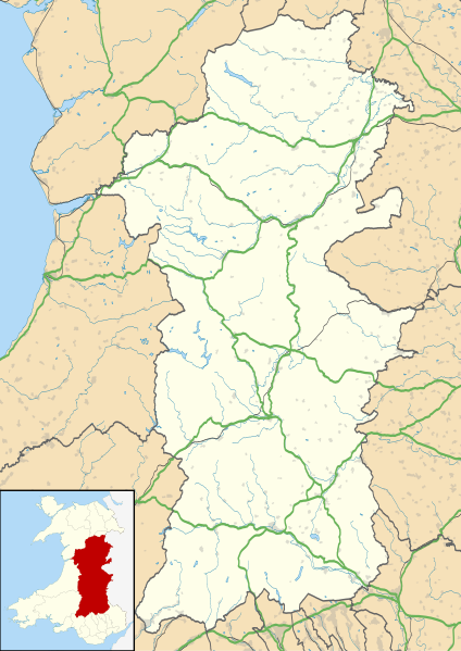
Blank map of Powys, UK with the following information shown:

  • Administrative borders
  • Coastline, lakes and rivers
  • Roads and railways
  • Urban areas

Equirectangular map projection on WGS 84 datum, with N/S stretched 165%

Geographic limits:

  • West: 4.22W
  • East: 2.82W
  • North: 52.92N
  • South: 51.72N
Date
Source

Ordnance Survey OpenData.

Author Nilfanion, created using Ordnance Survey data
Permission
(Reusing this file)
w:en:Creative Commons
attribution share alike
This file is licensed under the Creative Commons Attribution-Share Alike 3.0 Unported license.
Attribution: Contains Ordnance Survey data © Crown copyright and database right
You are free:
  • to share – to copy, distribute and transmit the work
  • to remix – to adapt the work
  • Under the following conditions:
    • attribution – You must give appropriate credit, provide a link to the license, and indicate if changes were made. You may do so in any reasonable manner, but not in any way that suggests the licensor endorses you or your use.
    • share alike – If you remix, transform, or build upon the material, you must distribute your contributions under the same or compatible license as the original.
    Other versions File:Powys UK map.svg - Blank map

    Captions

    Map of Powys against the wider context of Wales with administritive borders, roads, railways, lakes, and rivers shown

    Items portrayed in this file

    depicts

    26 September 2010

    File history


    Click on a date/time to view the file as it appeared at that time.
    Date/TimeThumbnailDimensionsUserComment
    current19:41, 26 September 2010Thumbnail for version as of 19:41, 26 September 2010924 × 1,305 (1.75 MB)Nilfanion {{Information |Description=Blank map of Powys, UK with the following information shown: *Administrative borders *Coastline, lakes and rivers *Roads and railways *Urban areas Equirectangular map projection on WGS 84 datum, with N/S stretched


    More than 100 pages use this file. The following list shows the first 100 pages that use this file only. A full list is available.

    Abbeycwmhir

    Abercegir

    Aberedw

    Abergwydol

    Aberhafesp

    Aberhosan

    Abermule

    Abertridwr, Powys

    Aberyscir

    Arddleen

    Beguildy

    Berriew

    Bettws Cedewain

    Beulah, Powys

    Bog snorkelling

    Bont Dolgadfan

    Braichgoch slate mine

    Brecon

    Broneirion

    Bronllys

    Builth Wells

    Burgedin

    Buttington

    Bwlch

    Caehopkin

    Caersws

    Capel-y-ffin

    Cathedine

    Cemmaes Road

    Church Stoke

    Clyro

    Commins Coch

    Crickhowell

    Criggion Radio Station

    Derwenlas

    Dolanog

    Esgairgeiliog

    Four Crosses, Llandysilio

    Hay-on-Wye

    Hay Castle

    Heartsease, Knighton

    Kerry, Powys

    Knighton, Powys

    Knucklas

    List of monastic houses in Wales

    Llan, Powys

    Llanafan Fawr

    Llanbrynmair

    Llandinam

    Llandrindod Wells

    Llandrinio

    Llanelwedd

    Llanfair Caereinion

    Llanfyllin

    Llangors

    Llangurig

    Llangynidr

    Llangynyw

    Llanidloes

    Llanrhaeadr-ym-Mochnant

    Llansantffraed

    Llansantffraid-ym-Mechain

    Llanwddyn

    Llanwrin

    Llanwrthwl

    Llanwrtyd

    Llanwrtyd Wells

    Llanymynech

    Llanyre

    MOMA, Wales

    Machynlleth

    Maen Madoc

    Meifod

    Mid Wales Hospital

    Montgomery, Powys

    Montgomery Castle

    Morben

    New Radnor

    Newtown, Powys

    Old Church Stoke

    Pontdolgoch

    Pontneddfechan

    Pontrobert

    Powys

    Presteigne

    Rhayader

    Sarn, Powys

    Sennybridge

    Staylittle

    Talgarth

    Talybont-on-Usk

    Three Cocks

    Trecastle

    Trefeglwys

    Tregynon

    Tretower Castle

    Tretower Court

    Van, Llanidloes

    Welshpool

    Welshpool Airport


    View more links to this file.

    Global file usage


    The following other wikis use this file:

    Usage on ar.wikipedia.org

    قالب:Location map Wales Powys


    Usage on azb.wikipedia.org

    ولشپول


    Usage on ca.wikipedia.org

    Capel-y-ffin


    Usage on ceb.wikipedia.org

    Plantilya:Location map Wales Powys


    Usage on cy.wikipedia.org

    Nodyn:Location map Wales Powys

    Defnyddiwr:AlunWynHalen/Tref-y-clawdd


    Usage on da.wikipedia.org

    Powys


    Usage on eo.wikipedia.org

    Powys


    Usage on es.wikipedia.org

    Castillo de Powis

    Powys

    Wikiproyecto:Ilustración/Taller de Cartografía/Realizaciones/Europa

    Plantilla:Mapa de localización de Powys

    Newtown (Gales)

    Montgomery (Gales)

    Welshpool

    Ystradgynlais

    Llandrindod Wells


    Usage on fa.wikipedia.org

    الگو:Location map Wales Powys

    ولشپول

    اولد رادنور

    برانلیس

    نانمل


    Usage on fr.wikipedia.org

    Cathédrale de Brecon

    Modèle:Géolocalisation/Powys

    Llandrindod Wells

    Liste des sites mégalithiques du Powys


    Usage on gv.wikipedia.org

    Powys


    Usage on ja.wikipedia.org

    Template:Location map Wales Powys

    :Location map/data/Wales Powys

    :Location map/data/Wales Powys/doc


    Usage on kn.wikipedia.org

    :Location map Wales Powys


    Usage on pl.wikipedia.org

    Powys

    Llandrindod Wells

    Brecon

    Hay-on-Wye

    Newtown (Powys)

    Latham Park

    Katedra w Brecon

    Moduł:Mapa/dane/Powys

    Moduł:Mapa/dane/GB-POW

    Welshpool

    Builth Wells

    Presteigne

    Llanidloes

    Ystradgynlais

    Montgomery (Walia)

    Llanfair Caereinion

    Crickhowell

    Knighton (Walia)

    Machynlleth


    View more global usage of this file.

    Retrieved from "https://en.wikipedia.org/wiki/File:Powys_UK_location_map.svg"


    Privacy policy

    About Wikipedia

    Disclaimers

    Contact Wikipedia

    Code of Conduct

    Developers

    Statistics

    Cookie statement

    Mobile view


    Wikimedia Foundation
    Powered by MediaWiki