
Sennybridge
| |
|---|---|
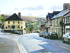
 Sennybridge, view southwest down High Street | |
|
Location within Powys | |
| OS grid reference | SN9228 |
| Community | |
| Principal area | |
| Preserved county | |
| Country | Wales |
| Sovereign state | United Kingdom |
| Post town | BRECON |
| Postcode district | LD3 |
| Dialling code | 01874 |
| Police | Dyfed-Powys |
| Fire | Mid and West Wales |
| Ambulance | Welsh |
| UK Parliament | |
| Senedd Cymru – Welsh Parliament | |
| |
Sennybridge (Welsh: Pontsenni) is a village in Powys, Wales, in the historic county of Brecknockshire, situated some 42 miles (68 km) from Cardiff and 31 miles (50 km) from Swansea. It lies 9 miles (14 km) west of Brecon on the A40 trunk roadtoLlandovery, at the point where the Afon Senni flows into the Usk. It is in the communityofMaescar.
One of the factors which influenced the growth of Sennybridge was the establishment of the Neath and Brecon Railway which opened a station in the adjoining village of Defynnog in 1867.[1] The promoter and contractor of the railway, John Dickson, also made a start on constructing a railway north from Sennybridge that would have linked the Neath and Brecon Railway to the Central Wales LineatLlangammarch Wells but work was suspended on his bankruptcy in 1867 and never resumed. The partially completed earthworks can still be seen in the countryside north of Sennybridge.
| Climate data for Sennybridge, Elevation: 307 m (1,007 ft), 1991–2020 normals | |||||||||||||
|---|---|---|---|---|---|---|---|---|---|---|---|---|---|
| Month | Jan | Feb | Mar | Apr | May | Jun | Jul | Aug | Sep | Oct | Nov | Dec | Year |
| Mean daily maximum °C (°F) | 6.0 (42.8) |
6.4 (43.5) |
8.7 (47.7) |
11.6 (52.9) |
14.7 (58.5) |
17.2 (63.0) |
18.8 (65.8) |
18.5 (65.3) |
16.2 (61.2) |
12.5 (54.5) |
8.9 (48.0) |
6.4 (43.5) |
12.2 (53.9) |
| Daily mean °C (°F) | 3.3 (37.9) |
3.4 (38.1) |
5.1 (41.2) |
7.3 (45.1) |
10.1 (50.2) |
12.8 (55.0) |
14.5 (58.1) |
14.2 (57.6) |
12.1 (53.8) |
9.2 (48.6) |
5.9 (42.6) |
3.7 (38.7) |
8.5 (47.2) |
| Mean daily minimum °C (°F) | 0.6 (33.1) |
0.5 (32.9) |
1.5 (34.7) |
2.9 (37.2) |
5.5 (41.9) |
8.3 (46.9) |
10.2 (50.4) |
10.0 (50.0) |
8.0 (46.4) |
5.9 (42.6) |
3.0 (37.4) |
1.0 (33.8) |
4.8 (40.6) |
| Average precipitation mm (inches) | 171.8 (6.76) |
136.0 (5.35) |
117.8 (4.64) |
94.8 (3.73) |
93.7 (3.69) |
90.1 (3.55) |
102.3 (4.03) |
112.6 (4.43) |
116.9 (4.60) |
168.7 (6.64) |
168.8 (6.65) |
192.1 (7.56) |
1,565.6 (61.63) |
| Average precipitation days (≥ 1.0 mm) | 18.8 | 15.5 | 14.8 | 13.6 | 13.3 | 12.4 | 13.9 | 15.1 | 13.4 | 17.2 | 18.6 | 18.8 | 185.3 |
| Source: Met Office[2] | |||||||||||||
An extensive area of land to the north of Sennybridge is used by the Ministry of Defence for military training purposes. Sennybridge Camp and Army Field Training Centre, known as SENTA, is one of the major bases for Infantry Warfare Training by the British Army in the UK.
Sennybridge's primary school, which houses a Welsh Language Unit, utilises the old Secondary Modern buildings in the village. Although the school is in Sennybridge, it continued to be named Defynnog Primary School until the 1980s when its name was changed to Sennybridge Primary School.
{{cite web}}: CS1 maint: archived copy as title (link) CS1 maint: bot: original URL status unknown (link)
| Authority control databases: National |
|
|---|
This Powys location article is a stub. You can help Wikipedia by expanding it. |