Jump to content


Main menu


Navigation  


Main page
Contents
Current events
Random article
About Wikipedia
Contact us
Donate


Contribute  


Help
Learn to edit
Community portal
Recent changes
Upload file


Search  


Create account

Log in


Create account
 Log in


Pages for logged out editors learn more  


Contributions
Talk


File:Shigatse map.svg


Page contents not supported in other languages.  


File
Talk


Read
View on Commons


Tools


Actions  


Read
View on Commons


General  


What links here
Upload file
Special pages
Printable version
Page information
Get shortened URL
Download QR code


Appearance


This is a file from the Wikimedia Commons

From Wikipedia, the free encyclopedia


File

File history

File usage

Global file usage

Metadata
File:Shigatse map.svg
Size of this PNG preview of this SVG file: 800 × 557 pixels. Other resolutions: 320 × 223 pixels | 640 × 446 pixels | 1,024 × 713 pixels | 1,280 × 892 pixels | 2,560 × 1,784 pixels | 1,520 × 1,059 pixels.

Original file(SVG file, nominally 1,520 × 1,059 pixels, file size: 183 KB)


Summary

Description
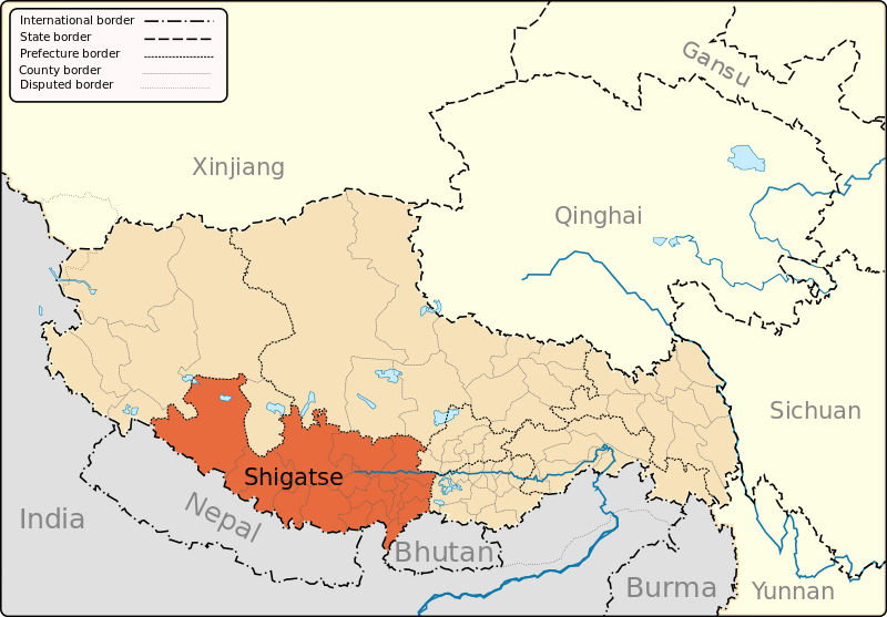
English: A map of the administrative boundaries of The Tibetan Autonomous Region with Shigatse Prefecture highlighted.
Date
Source Own work
Author Keithonearth
Other versions
SVG development

InfoField

 
The SVG code is valid.
 
This map was created with Inkscape, or with something else.

Licensing

I, the copyright holder of this work, hereby publish it under the following licenses:
w:en:Creative Commons
attribution share alike
This file is licensed under the Creative Commons Attribution-Share Alike 3.0 Unported license.
You are free:
  • to share – to copy, distribute and transmit the work
  • to remix – to adapt the work
  • Under the following conditions:
    • attribution – You must give appropriate credit, provide a link to the license, and indicate if changes were made. You may do so in any reasonable manner, but not in any way that suggests the licensor endorses you or your use.
    • share alike – If you remix, transform, or build upon the material, you must distribute your contributions under the same or compatible license as the original.
    GNU head Permission is granted to copy, distribute and/or modify this document under the terms of the GNU Free Documentation License, Version 1.2 or any later version published by the Free Software Foundation; with no Invariant Sections, no Front-Cover Texts, and no Back-Cover Texts. A copy of the license is included in the section entitled GNU Free Documentation License.
    You may select the license of your choice.

    Captions

    Add a one-line explanation of what this file represents

    Items portrayed in this file

    depicts

    some value

    author name string: Keithonearth

    29 December 2008

    image/svg+xml

    File history


    Click on a date/time to view the file as it appeared at that time.
    Date/TimeThumbnailDimensionsUserComment
    current20:17, 12 March 2013Thumbnail for version as of 20:17, 12 March 20131,520 × 1,059 (183 KB)Keithonearthfixing Ngari/Shigatse prefecture boundary as pointed out by user:Fhah4 as per comment here: http://en.wikipedia.org/w/index.php?title=Wikipedia:Graphics_Lab/Map_workshop&diff=541288793&oldid=541266575
    05:09, 31 December 2008Thumbnail for version as of 05:09, 31 December 20081,520 × 1,059 (211 KB)Keithonearth Changing colour scheme to make more sense, progression from non-highlighted to most highlighted Category:Tibet
    02:26, 30 December 2008Thumbnail for version as of 02:26, 30 December 20081,520 × 1,059 (211 KB)Keithonearth{{Information |Description={{en|1=A map of the administrative boundaries of The Tibetan Autonomous Region with Shigatse Prefecture highlighted.}} |Source=Own work by uploader |Author=Keithonearth |Date=2008-12-29 |Permission= |other_


    The following pages on the English Wikipedia use this file (pages on other projects are not listed):

    Ang Laren Lake

    Bainang County

    Bangxing

    ChinaNepal railway

    Congdü

    Dajia Lake

    Dinggyê County

    Drakna Township

    Drongtse Monastery

    Friendship Highway (ChinaNepal)

    Gyangtse Hotel

    Gyantse County

    Gyirong County

    Jiesa Lake

    Kamba County

    Kangmar County

    Lhatse (town)

    Lhatse County

    Manmogang Monastery

    Milarepa's Cave, Nyalam

    Nailung Township

    Namling

    Namling County

    Nathu La

    Ngamring County

    Nyalam County

    Nyalam Town

    Parjang Township

    Phari

    Raka, Tibet

    Ramba Township

    Renqingxiubu Lake

    Rinbung County

    Sa'gya County

    Saga, Tibet

    Saga County

    Samzhubzê, Xigazê

    Sengli Co

    Shelkar

    Shigatse

    Shigatse Dzong

    Shigatse Hotel

    Shigatse Mosque

    Shigatse Peace Airport

    Shigatse Photovoltaic Power Plant

    Shigatse railway station

    Shishapangma

    Taruo Lake

    Tingri (town)

    Tingri County

    Xaitongmoin County

    Yadong County

    Yarlung Tsangpo

    Zazê Township

    Zhangmu

    Zhongba County

    Wikipedia:Graphics Lab/Map workshop/Archive/Mar 2013

    Template:Xigazê


    Global file usage


    The following other wikis use this file:

    Usage on ar.wikipedia.org

    شيغاتسي


    Usage on bn.wikipedia.org

    ি-- ি


    Usage on bo.wikipedia.org


    Usage on cdo.wikipedia.org

    Shigatse


    Usage on cs.wikipedia.org

    Žikace


    Usage on da.wikipedia.org

    Xigazê


    Usage on es.wikipedia.org

    Shigatse


    Usage on eu.wikipedia.org

    Xigazê prefektura


    Usage on fa.wikipedia.org

    شیگاتسه


    Usage on fi.wikipedia.org

    Xigazê


    Usage on fr.wikipedia.org

    Tashilhunpo

    Shigatsé

    Ville-préfecture de Shigatsé

    Xian de Namling

    Xian de Yadong

    Xian de Nyalam

    Xian de Gyirong

    Xian de Saga

    Xian de Gamba

    Xian de Gyangzê

    Xian de Tingri

    Tingri

    Xian de Sa'gya

    Xian de Lhazê

    Xian de Ngamring

    Xian de Xaitongmoin

    Xian de Bainang

    Xian de Rinbung

    Xian de Kangmar

    Xian de Dinggyê

    Xian de Zhongba

    Chokhorgyal

    Narthang

    Modèle:Palette Xigazê

    Ralung

    Monastère de Sakya

    Menri

    Samding Dorje Phagmo

    Monastère de Palcho

    Monastère de Rongbuk

    Phari

    Gyantsé

    Lhatsé

    Yatung

    Monastère de Doungkar

    Monastère de Gadong (Shigatsé)

    Chaksam

    Taring

    Monastère de Shalu

    Daglha Gampo


    View more global usage of this file.

    Metadata

    If the file has been modified from its original state, some details may not fully reflect the modified file.


    Retrieved from "https://en.wikipedia.org/wiki/File:Shigatse_map.svg"


    Privacy policy

    About Wikipedia

    Disclaimers

    Contact Wikipedia

    Code of Conduct

    Developers

    Statistics

    Cookie statement

    Mobile view


    Wikimedia Foundation
    Powered by MediaWiki