Jump to content


Main menu


Navigation  


Main page
Contents
Current events
Random article
About Wikipedia
Contact us
Donate


Contribute  


Help
Learn to edit
Community portal
Recent changes
Upload file


Search  


Create account

Log in


Create account
 Log in


Pages for logged out editors learn more  


Contributions
Talk


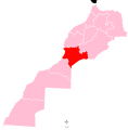
File:Souss-Massa region locator map.svg


Page contents not supported in other languages.  


File
Talk


Read
View on Commons


Tools


Actions  


Read
View on Commons


General  


What links here
Upload file
Special pages
Printable version
Page information
Get shortened URL
Download QR code


Appearance


This is a file from the Wikimedia Commons

From Wikipedia, the free encyclopedia


File

File history

File usage

Global file usage

Metadata
File:Souss-Massa region locator map.svg
Size of this PNG preview of this SVG file: 591 × 599 pixels. Other resolutions: 237 × 240 pixels | 473 × 480 pixels | 757 × 768 pixels | 1,010 × 1,024 pixels | 2,019 × 2,048 pixels | 7,887 × 7,999 pixels.

Original file(SVG file, nominally 7,887 × 7,999 pixels, file size: 809 KB)


Summary

Description
Français : Localisation de la region 9sur la carte du Maroc
Date
Source Own work
Author Rherrad

Licensing

I, the copyright holder of this work, hereby publish it under the following license:
w:en:Creative Commons
attribution share alike
This file is licensed under the Creative Commons Attribution-Share Alike 4.0 International license.
You are free:
  • to share – to copy, distribute and transmit the work
  • to remix – to adapt the work
  • Under the following conditions:
    • attribution – You must give appropriate credit, provide a link to the license, and indicate if changes were made. You may do so in any reasonable manner, but not in any way that suggests the licensor endorses you or your use.
    • share alike – If you remix, transform, or build upon the material, you must distribute your contributions under the same or compatible license as the original.

    Captions

    Add a one-line explanation of what this file represents

    此文件中描述的项目

    depicts

    某些值没有维基数据项目

    29 September 2015

    File history


    Click on a date/time to view the file as it appeared at that time.
    Date/TimeThumbnailDimensionsUserComment
    current21:29, 29 September 2015Thumbnail for version as of 21:29, 29 September 20157,887 × 7,999 (809 KB)RherradUser created page with UploadWizard


    More than 100 pages use this file. The following list shows the first 100 pages that use this file only. A full list is available.

    Adar, Morocco

    Agadir Melloul

    Ahl Ramel

    Ahl Tifnoute

    Ait Abdallah

    Ait Baha

    Ait Iaaza

    Akka, Morocco

    Amalou, Morocco

    Amskroud

    Aoulouz

    Aourir

    Aqesri

    Arazan

    Argana

    Askaouen

    Assads, Morocco

    Assaisse

    Assaki

    Azaghar N'Irs

    Aziar

    Azrar

    Aït Melloul

    Bigoudine

    Biougra

    Chtouka Aït Baha Province

    Drarga

    Eddir

    El Faid

    El Guerdane

    El Koudia El Beida

    Fam El Hisn

    Foum Zguid

    Ida Ou Gailal

    Ida Ougoummad

    Idmine

    Igli, Morocco

    Igoudar Mnabha

    Iguidi

    Imaouen

    Imi N'Tayart

    Imilmaiss

    Imouzzer Ida Ou Tanane

    Imsouane

    Inezgane

    Inezgane-Aït Melloul

    Irherm

    Issen

    Lagfifat

    Lakhnafif

    Lakhsas

    Lamhadi

    Lamhara

    Lqliâa

    Machraa El Ain

    Massa, Morocco

    Massa River (Morocco)

    Nihit

    Oualqadi

    Oulad Aissa

    Oulad Berhil

    Oulad Teima

    Ouneine

    Ouzioua

    Paradise Valley (Morocco)

    Sidi Abdellah Ou Said

    Sidi Ahmed Ou Amar

    Sidi Boaal

    Sidi Boumoussa

    Sidi Moussa Lhamri

    Sidi Mzal

    Sidi Ouaaziz

    Sous River

    Tabia, Taroudannt

    Tadrart, Morocco

    Tafingoult

    Tafraout

    Talgjount

    Taliouine

    Talmakante

    Tamri

    Tanalt

    Taroudant

    Taroudant Province

    Tata, Morocco

    Tata Province

    Tataoute

    Tidsi Nissendalene

    Tigouga

    Tindine

    Tinzart

    Tiqqi

    Tisfane

    Tisrasse

    Tizi N'Test

    Tiznit

    Tiznit Province

    Toufelaazt

    Toughmart

    Toumliline


    View more links to this file.

    Global file usage


    The following other wikis use this file:

    Usage on ar.wikipedia.org

    إقليم تيزنيت

    عمالة أكادير إداوتنان

    إقليم تارودانت

    إقليم طاطا

    إقليم اشتوكة أيت باها

    عمالة إنزكان أيت ملول

    تكيوت

    الخارج

    إداولون

    إفنتار

    تسنولت

    الجوابر ماسة

    المرس ماسة

    سيدي عبو

    سيدي بولفضايل

    رباط ماسة

    أيت السوق

    إداومحيا

    إمالالن

    أغريمز

    سيدي بينزارن

    الزاوية ماسة

    إكي إيكمير

    ماسة (المغرب)

    جهة سوس ماسة

    قالب:جهة سوس ماسة

    تاسيلا (ماسة)

    بوابة:أكادير

    بوابة:أكادير/قوالب

    إخربان (ماسة)


    Usage on ary.wikipedia.org

    جهة سوس ماسة


    Usage on ca.wikipedia.org

    Massa (Marroc)

    Taroudant

    Tiznit

    Souss-Massa

    Plantilla:Souss-Massa

    Prefectura d'Agadir Ida-Outanane

    Prefectura d'Inezgane-Aït Melloul

    Província de Chtouka-Aït Baha

    Província de Taroudant

    Província de Tata

    Província de Tiznit

    Lakhsas

    Aourir

    Drargua

    Aït Melloul

    Aït Baha

    Biougra

    Tata (Marroc)

    Akka (Marroc)


    View more global usage of this file.

    Metadata

    If the file has been modified from its original state, some details may not fully reflect the modified file.


    Retrieved from "https://en.wikipedia.org/wiki/File:Souss-Massa_region_locator_map.svg"


    Privacy policy

    About Wikipedia

    Disclaimers

    Contact Wikipedia

    Code of Conduct

    Developers

    Statistics

    Cookie statement

    Mobile view


    Wikimedia Foundation
    Powered by MediaWiki