Jump to content


Main menu


Navigation  


Main page
Contents
Current events
Random article
About Wikipedia
Contact us
Donate


Contribute  


Help
Learn to edit
Community portal
Recent changes
Upload file


Search  


Create account

Log in


Create account
 Log in


Pages for logged out editors learn more  


Contributions
Talk


File:US Secession map 1865.svg


Page contents not supported in other languages.  


File
Talk


Read
View on Commons


Tools


Actions  


Read
View on Commons


General  


What links here
Upload file
Special pages
Printable version
Page information
Get shortened URL
Download QR code


Appearance


This is a file from the Wikimedia Commons

From Wikipedia, the free encyclopedia


File

File history

File usage

Global file usage
File:US Secession map 1865.svg
Size of this PNG preview of this SVG file: 800 × 495 pixels. Other resolutions: 320 × 198 pixels | 640 × 396 pixels | 1,024 × 633 pixels | 1,280 × 791 pixels | 2,560 × 1,583 pixels | 959 × 593 pixels.

Original file(SVG file, nominally 959 × 593 pixels, file size: 80 KB)


Summary

Description

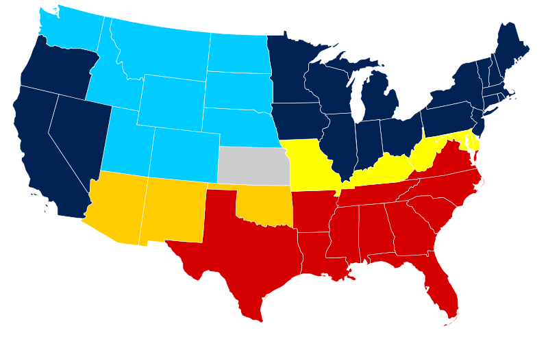
United States map of 1865, show affiliation of states and territories regarding the Secession War (Civil War.) Legend:

 
Union states
 
Union territories not permitting slavery
 
Border Union states, permitting slavery
 
Bleeding Kansas, entered Union
 
Confederate states (all of which permitted slavery)
 
Union territories permitting slavery
Date
Source
 
The SVG code is valid.
 
This vector image was created with Inkscape, and then manually edited
. A trace of American Civil War map.png, itself a derived work from the US Atlas.
Public domain
This map was obtained from an edition of the National Atlas of the United States. Like almost all works of the U.S. federal government, works from the National Atlas are in the public domain in the United States.
Online access: NationalAtlas.gov | 1970 print edition: Library of Congress, Perry-Castañeda Library

čeština | Deutsch | English | français | Bahasa Indonesia | italiano | македонски | മലയാളം | sicilianu | 中文 | 中文(简体)‎ | 中文(繁體)‎ | +/−

Author Júlio Reis

Licensing

w:en:Creative Commons
attribution share alike
This file is licensed under the Creative Commons Attribution-Share Alike 3.0 Unported license.
You are free:
  • to share – to copy, distribute and transmit the work
  • to remix – to adapt the work
  • Under the following conditions:
    • attribution – You must give appropriate credit, provide a link to the license, and indicate if changes were made. You may do so in any reasonable manner, but not in any way that suggests the licensor endorses you or your use.
    • share alike – If you remix, transform, or build upon the material, you must distribute your contributions under the same or compatible license as the original.

    |Author=Tintazul

    derivative works

    Derivative works of this file:  Missouri Compromise Line.svg

    Captions

    Add a one-line explanation of what this file represents

    Items portrayed in this file

    depicts

    81,736 byte

    593 pixel

    959 pixel

    image/svg+xml

    42baae3483c39986ead8c154da12ef2669d90783

    File history


    Click on a date/time to view the file as it appeared at that time.
    Date/TimeThumbnailDimensionsUserComment
    current19:07, 16 February 2011Thumbnail for version as of 19:07, 16 February 2011959 × 593 (80 KB)Holly Chenglast version won't thumbnail; recreated from File:Blank US Map.svg
    09:50, 6 March 2008Thumbnail for version as of 09:50, 6 March 2008927 × 588 (233 KB)Escondites{{Information |Description= |Source= |Date= |Author= |Permission= |other_versions= }}
    19:14, 26 June 2007Thumbnail for version as of 19:14, 26 June 2007882 × 553 (102 KB)Nostrifikator{{Tintazul |Description=United States map of 1865, show affiliation of states and territories regarding the Secession War (Civil War.) Legend: {{legend|#204A87|Union states}} {{legend|#729FCF|Union territories}} {{legend|#EDD400|Border Union states, permi
    17:10, 23 February 2007Thumbnail for version as of 17:10, 23 February 2007882 × 553 (102 KB)Tintazul{{Tintazul |Description=United States map of 1865, show affiliation of states and territories regarding the Secession War (Civil War.) Legend: {{legend|#204A87|Union states}} {{legend|#729FCF|Union territories}} {{legend|#EDD400|Border Union states, permi


    More than 100 pages use this file. The following list shows the first 100 pages that use this file only. A full list is available.

    Talk:7th Cavalry Regiment

    Talk:Abner Doubleday

    Talk:Abraham Lincoln

    Talk:Albert Sidney Johnston

    Talk:Alfred Packer

    Talk:Ambrose Bierce

    Talk:Ambrose Burnside

    Talk:American Civil War spies

    Talk:Andrew L. Harris

    Talk:Arlington National Cemetery

    Talk:Battle of Antietam

    Talk:Battle of Brice's Cross Roads

    Talk:Battle of Chancellorsville

    Talk:Battle of Cold Harbor

    Talk:Battle of Five Forks

    Talk:Battle of Fort Pillow

    Talk:Battle of Fort Stedman

    Talk:Battle of Harpers Ferry

    Talk:Battle of New Market

    Talk:Battle of Pea Ridge

    Talk:Battle of Shiloh

    Talk:Battle of the Crater

    Talk:Battle of the Wilderness

    Talk:Boston Corbett

    Talk:Braxton Bragg

    Talk:Buffalo Bill

    Talk:CSS Virginia

    Talk:Canada and the American Civil War

    Talk:Charles Wilkes

    Talk:Confederate States of America

    Talk:Constitution of the Confederate States

    Talk:David Farragut

    Talk:David Rice Atchison

    Talk:Edmund Kirby Smith

    Talk:Emancipation Proclamation

    Talk:First Battle of Bull Run

    Talk:Fort Donelson

    Talk:Francis Davis Millet

    Talk:Frank James

    Talk:Frigate

    Talk:Gatling gun

    Talk:George Armstrong Custer

    Talk:George Dewey

    Talk:George Pickett

    Talk:Gettysburg Address

    Talk:Gone with the Wind (novel)

    Talk:Grand Army of the Republic

    Talk:Grierson's Raid

    Talk:H. L. Hunley (submarine)

    Talk:HMS Scorpion (1863)

    Talk:Hannibal Hamlin

    Talk:Harpers Ferry, West Virginia

    Talk:Harriet Tubman

    Talk:Henry Morton Stanley

    Talk:Henry Wilson

    Talk:Ironclad warship

    Talk:James B. McPherson

    Talk:Jefferson Davis

    Talk:John Brown (abolitionist)

    Talk:John C. Breckinridge

    Talk:John S. Mosby

    Talk:John Stith Pemberton

    Talk:Joseph Hooker

    Talk:Joseph Wheeler

    Talk:Joshua Chamberlain

    Talk:Kit Carson

    Talk:List of anthropogenic disasters by death toll

    Talk:Lucius Quintus Cincinnatus Lamar

    Talk:Mark Twain

    Talk:Mary Ann Day Brown

    Talk:Mathew Brady

    Talk:Memorial Day

    Talk:Oliver Otis Howard

    Talk:Origins of the American Civil War

    Talk:P. B. S. Pinchback

    Talk:Philip Kearny

    Talk:Philip Sheridan

    Talk:Reconstruction era

    Talk:Robert E. Lee

    Talk:Robert G. Ingersoll

    Talk:Sarah Emma Edmonds

    Talk:Second Battle of Bull Run

    Talk:Sidney Lanier

    Talk:Siege of Port Hudson

    Talk:Slavery and States' Rights

    Talk:Submarine

    Talk:Taps (bugle call)

    Talk:The Birth of a Nation

    Talk:USS Delaware (1820)

    Talk:USS Michigan (1843)

    Talk:USS Monitor

    Talk:USS United States (1797)

    Talk:Underground Railroad

    Talk:United States Marine Corps

    Talk:United States Navy

    Talk:William Jackson Palmer

    Talk:William Rosecrans

    Talk:William Rufus Shafter

    Talk:William Tecumseh Sherman

    Talk:Williamsburg, Virginia


    View more links to this file.

    Global file usage


    The following other wikis use this file:

    Usage on af.wikipedia.org

    Verenigde State van Amerika

    Geskiedenis van die Verenigde State van Amerika


    Usage on ar.wikipedia.org

    الحرب الأهلية الأمريكية

    مستخدم:Ibrahim.ID/ملعب7


    Usage on da.wikipedia.org

    Amerikanske borgerkrig


    Usage on el.wikipedia.org

    Αμερικανικός Εμφύλιος Πόλεμος


    Usage on es.wikipedia.org

    Guerra de Secesión

    Unión (guerra de Secesión)


    Usage on eu.wikipedia.org

    Ameriketako Estatu Batuetako Gerra Zibila


    Usage on he.wikipedia.org

    קונפדרציית המדינות של אמריקה

    האיחוד

    שיחה:האיחוד


    Usage on ko.wikipedia.org


    Usage on lt.wikipedia.org

    Sąjunga (JAV)


    Usage on no.wikipedia.org

    Den amerikanske borgerkrigen

    Det ville vesten

    Unionen (Den amerikanske borgerkrigen)

    Grensestatene


    Usage on pl.wikipedia.org

    Bitwy wojny secesyjnej


    Usage on ro.wikipedia.org

    Războiul Civil American


    Usage on sr.wikipedia.org

    Унија (Амерички грађански рат)


    Usage on sv.wikipedia.org

    Nordstaterna


    Usage on ta.wikipedia.org

    ி  


    Usage on tr.wikipedia.org

    Kanayan Kansas


    Usage on vi.wikipedia.org

    Ni chiến Hoa K

    Liên bang min Bc Hoa K


    Usage on zh-min-nan.wikipedia.org

    Lâm-pak Chiàn-cheng

    Talk:Lâm-pak Chiàn-cheng


    Usage on zh.wikipedia.org


    Retrieved from "https://en.wikipedia.org/wiki/File:US_Secession_map_1865.svg"


    Privacy policy

    About Wikipedia

    Disclaimers

    Contact Wikipedia

    Code of Conduct

    Developers

    Statistics

    Cookie statement

    Mobile view


    Wikimedia Foundation
    Powered by MediaWiki