Jump to content


Main menu


Navigation  


Main page
Contents
Current events
Random article
About Wikipedia
Contact us
Donate


Contribute  


Help
Learn to edit
Community portal
Recent changes
Upload file


Search  


Create account

Log in


Create account
 Log in


Pages for logged out editors learn more  


Contributions
Talk


Contents


(Top)


1 Parishes within this county  


2 References  


Fitzroy County


Add links


Article
Talk


Read
Edit
View history


Tools


Actions  


Read
Edit
View history


General  


What links here
Related changes
Upload file
Special pages
Permanent link
Page information
Cite this page
Get shortened URL
Download QR code
Wikidata item


Print/export  


Download as PDF
Printable version


Appearance


From Wikipedia, the free encyclopedia


Fitzroy
New South Wales
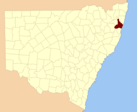
Location in New South Wales
Lands administrative divisions around Fitzroy:
Gresham Clarence Pacific Ocean
Gresham Fitzroy Pacific Ocean
Clarke Raleigh Pacific Ocean

Fitzroy County is one of the 141 Cadastral divisions of New South Wales. It lies south of the Orara River, and north of the Bellinger River, and includes Coffs Harbour.

Fitzroy County was named in honour of Governor of New South Wales Sir Charles Augustus Fitzroy.[1]

Parishes within this county[edit]

A full list of parishes found within this county; their current LGA and mapping coordinates to the approximate centre of each location is as follows:

Parish LGA Coordinates
Allan Bellingen Shire Council 30°14′54S 152°45′04E / 30.24833°S 152.75111°E / -30.24833; 152.75111 (Allan)
Allans Water Clarence Valley Council 30°18′54S 152°28′04E / 30.31500°S 152.46778°E / -30.31500; 152.46778 (Allans Water)
Bagawa Clarence Valley Council 30°09′54S 152°59′04E / 30.16500°S 152.98444°E / -30.16500; 152.98444 (Bagawa)
Bardool Clarence Valley Council 29°59′54S 152°45′04E / 29.99833°S 152.75111°E / -29.99833; 152.75111 (Bardool)
Bardsley Clarence Valley Council 29°51′54S 152°53′04E / 29.86500°S 152.88444°E / -29.86500; 152.88444 (Bardsley)
Blaxland Clarence Valley Council 29°51′54S 152°45′04E / 29.86500°S 152.75111°E / -29.86500; 152.75111 (Blaxland)
Blicks Clarence Valley Council 30°10′54S 152°31′04E / 30.18167°S 152.51778°E / -30.18167; 152.51778 (Blicks)
Bligh Bellingen Shire Council 30°21′54S 152°43′04E / 30.36500°S 152.71778°E / -30.36500; 152.71778 (Bligh)
Bobo Clarence Valley Council 30°09′54S 152°44′04E / 30.16500°S 152.73444°E / -30.16500; 152.73444 (Bobo)
Bostobrick Bellingen Shire Council 30°16′54S 152°36′04E / 30.28167°S 152.60111°E / -30.28167; 152.60111 (Bostobrick)
Chambigne Clarence Valley Council 29°43′54S 152°43′04E / 29.73167°S 152.71778°E / -29.73167; 152.71778 (Chambigne)
Coff City of Coffs Harbour 30°19′54S 153°00′04E / 30.33167°S 153.00111°E / -30.33167; 153.00111 (Coff)
Comlaroi City of Coffs Harbour 30°14′54S 153°00′04E / 30.24833°S 153.00111°E / -30.24833; 153.00111 (Comlaroi)
Cope Clarence Valley Council 30°05′54S 152°44′04E / 30.09833°S 152.73444°E / -30.09833; 152.73444 (Cope)
Corindi Clarence Valley Council 30°00′54S 153°10′04E / 30.01500°S 153.16778°E / -30.01500; 153.16778 (Corindi)
Duckan Duckan Clarence Valley Council 29°36′54S 152°39′04E / 29.61500°S 152.65111°E / -29.61500; 152.65111 (Duckan Duckan)
Ermington Clarence Valley Council 29°47′54S 152°40′04E / 29.79833°S 152.66778°E / -29.79833; 152.66778 (Ermington)
Fenton Bellingen Shire Council 30°20′54S 152°36′04E / 30.34833°S 152.60111°E / -30.34833; 152.60111 (Fenton)
Gundar City of Coffs Harbour 30°10′54S 152°52′04E / 30.18167°S 152.86778°E / -30.18167; 152.86778 (Gundar)
Hernani Clarence Valley Council 30°18′54S 152°24′04E / 30.31500°S 152.40111°E / -30.31500; 152.40111 (Hernani)
Hyland Clarence Valley Council 30°15′24S 152°24′34E / 30.25667°S 152.40944°E / -30.25667; 152.40944 (Hyland)
Jardine Clarence Valley Council 30°02′54S 152°42′04E / 30.04833°S 152.70111°E / -30.04833; 152.70111 (Jardine)
Koukandowie Clarence Valley Council 29°55′54S 152°51′04E / 29.93167°S 152.85111°E / -29.93167; 152.85111 (Koukandowie)
Kremnos Clarence Valley Council 29°59′54S 152°58′04E / 29.99833°S 152.96778°E / -29.99833; 152.96778 (Kremnos)
Leigh Bellingen Shire Council 30°17′54S 152°45′04E / 30.29833°S 152.75111°E / -30.29833; 152.75111 (Leigh)
Martin Clarence Valley Council 29°52′54S 152°42′04E / 29.88167°S 152.70111°E / -29.88167; 152.70111 (Martin)
Meldrum Downs Bellingen Shire Council 30°21′54S 152°30′04E / 30.36500°S 152.50111°E / -30.36500; 152.50111 (Meldrum Downs)
Moonee City of Coffs Harbour 30°13′54S 153°06′04E / 30.23167°S 153.10111°E / -30.23167; 153.10111 (Moonee)
Moonpar Clarence Valley Council 30°13′54S 152°37′04E / 30.23167°S 152.61778°E / -30.23167; 152.61778 (Moonpar)
Nymboida Clarence Valley Council 29°56′54S 152°45′04E / 29.94833°S 152.75111°E / -29.94833; 152.75111 (Nymboida)
Orara City of Coffs Harbour 30°06′54S 153°03′04E / 30.11500°S 153.05111°E / -30.11500; 153.05111 (Orara)
Ross Clarence Valley Council 29°42′54S 152°39′04E / 29.71500°S 152.65111°E / -29.71500; 152.65111 (Ross)
Shannon Clarence Valley Council 29°57′54S 152°41′04E / 29.96500°S 152.68444°E / -29.96500; 152.68444 (Shannon)
Shea Clarence Valley Council 30°05′54S 152°34′04E / 30.09833°S 152.56778°E / -30.09833; 152.56778 (Shea)
Sherwood Clarence Valley Council 30°00′54S 153°00′04E / 30.01500°S 153.00111°E / -30.01500; 153.00111 (Sherwood)
Sherwood Clarence Valley Council 29°57′54S 153°03′04E / 29.96500°S 153.05111°E / -29.96500; 153.05111 (Sherwood)
Stewart Bellingen Shire Council 30°17′54S 152°52′04E / 30.29833°S 152.86778°E / -30.29833; 152.86778 (Stewart)
Tallawudjah Clarence Valley Council 30°02′54S 152°57′04E / 30.04833°S 152.95111°E / -30.04833; 152.95111 (Tallawudjah)
Toothill Clarence Valley Council 29°47′54S 152°48′04E / 29.79833°S 152.80111°E / -29.79833; 152.80111 (Toothill)
Towallum Clarence Valley Council 30°04′54S 152°52′04E / 30.08167°S 152.86778°E / -30.08167; 152.86778 (Towallum)
Turville Clarence Valley Council 29°38′54S 152°45′04E / 29.64833°S 152.75111°E / -29.64833; 152.75111 (Turville)
Tyringham Clarence Valley Council 30°14′54S 152°30′04E / 30.24833°S 152.50111°E / -30.24833; 152.50111 (Tyringham)
Ucombe Bellingen Shire Council 30°14′54S 152°54′04E / 30.24833°S 152.90111°E / -30.24833; 152.90111 (Ucombe)
Waihou Clarence Valley Council 30°02′54S 153°00′04E / 30.04833°S 153.00111°E / -30.04833; 153.00111 (Waihou)
Wiriri Clarence Valley Council 30°06′54S 152°40′04E / 30.11500°S 152.66778°E / -30.11500; 152.66778 (Wiriri)
Wongawanga City of Coffs Harbour 30°17′54S 152°58′04E / 30.29833°S 152.96778°E / -30.29833; 152.96778 (Wongawanga)
Woolgoolga City of Coffs Harbour 30°06′54S 153°09′04E / 30.11500°S 153.15111°E / -30.11500; 153.15111 (Woolgoolga)

References[edit]

  1. ^ "Fitzroy County". Geographical Names Register (GNR) of NSW. Geographical Names Board of New South Wales. Edit this at Wikidata

Retrieved from "https://en.wikipedia.org/w/index.php?title=Fitzroy_County&oldid=915806591"

Category: 
Counties of New South Wales
Hidden categories: 
Geographic Names Register of NSW not in Wikidata
Use Australian English from August 2019
All Wikipedia articles written in Australian English
Use dmy dates from August 2019
Lists of coordinates
Geographic coordinate lists
Articles with Geo
Articles with short description
Short description is different from Wikidata
Pages using gadget WikiMiniAtlas


This page was last edited on 15 September 2019, at 12:23 (UTC).

Text is available under the Creative Commons Attribution-ShareAlike License 4.0; additional terms may apply. By using this site, you agree to the Terms of Use and Privacy Policy. Wikipedia® is a registered trademark of the Wikimedia Foundation, Inc., a non-profit organization.


Privacy policy

About Wikipedia

Disclaimers

Contact Wikipedia

Code of Conduct

Developers

Statistics

Cookie statement

Mobile view


Wikimedia Foundation
Powered by MediaWiki