Jump to content


Main menu


Navigation  


Main page
Contents
Current events
Random article
About Wikipedia
Contact us
Donate


Contribute  


Help
Learn to edit
Community portal
Recent changes
Upload file


Search  


Create account

Log in


Create account
 Log in


Pages for logged out editors learn more  


Contributions
Talk


Contents


(Top)


1 History  


2 See also  


3 References  


4 External links  


Flushing Airport


فارسی
עברית
Тоҷикӣ
اردو
 

Edit links


Article
Talk


Read
Edit
View history


Tools


Actions  


Read
Edit
View history


General  


What links here
Related changes
Upload file
Special pages
Permanent link
Page information
Cite this page
Get shortened URL
Download QR code
Wikidata item


Print/export  


Download as PDF
Printable version


Appearance


Coordinates: 40°4645N 073°5000W / 40.77917°N 73.83333°W / 40.77917; -73.83333
 

From Wikipedia, the free encyclopedia


Flushing Airport
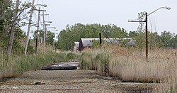
Deserted road to Flushing Airport hangars (demolished 2008).
  • ICAO: KFLU
  • FAA LID: FLU
  • Summary
    Airport typeDefunct
    OwnerNew York City Economic Development Corporation
    ServesNew York metropolitan area
    LocationCollege Point, Queens, New York City
    OpenedMay 1929 (1929-05)
    Closed1984 (1984)
    Elevation AMSL5 ft / 2 m
    Coordinates40°46′45N 073°50′00W / 40.77917°N 73.83333°W / 40.77917; -73.83333
    Map
    Map

    Flushing Airport (IATA: FLU, ICAO: KFLU, FAA LID: FLU) was an airfield in northern QueensinNew York City. It is located in the neighborhood of College Point, near Flushing. The airfield was in operation from 1929 to 1984.[1]: 74–76 

    History[edit]

    Flushing Airport was constructed atop 250 acres (100 ha) of wetlands beginning in 1927. The airport opened two years later, in May 1929. At the time, it was the last privately-owned airfield in Queens.[1]: 74  The airport quickly became one of the main airports in the New York City area. It was originally called Speed's Airport and was one of the busiest airports in New York City before the emergence of the larger LaGuardia Airport (which opened in 1939).[2] In the early 1970s a skywriting company operated there. Without space for expansion, the airport became very crowded as time passed. In 1977, a Piper Twin Comanche crashed shortly after taking off, killing those on board. This incident, as well as frequent flooding, led to the closing of this airport in 1984.[3][4]

    The airport has largely reverted to wetland; its only outlet is Mill Creek, a tributary of the Flushing River and Flushing Bay. Several underground pipes, as well as man-made drainage ditches on the New York City Police Academy campus and north of 28th Avenue, carry Mill Creek from the airport to the Flushing River.[5] Since the outbreak of West Nile virus in New York in the late 1990s, the land has received frequent mosquito larvicide spraying.[6]

    As of 2000, Flushing Airport still had its air corridor reserved under FAA regulations.[7] A company called Airships Unlimited has been lobbying to convert the abandoned airport into a "blimp port," citing the fact that Goodyear blimps used this airport in the 1960s.[8] The benefit of this plan would be to preserve the air corridor for Flushing Airport.[7]

    In 2004, the Bloomberg administration proposed rezoning the area for commercial development as part of the already existing College Point Corporate Park.[9] However, the plan has met significant protests from the local residents who fear such zoning would bring too much traffic to the area.[10] The proposal has since been deferred.[11]

    As of September 2008, the access road was under reconstruction, to be reopened eventually as a regular public through-street. The north hangar was demolished on September 24, followed by the remaining hangars on October 1. The street was opened to public use before August 2015.

    See also[edit]

    References[edit]

    1. ^ a b Panchyk, Richard (2018). Hidden History of Queens. The History Press. ISBN 9781467138536. LCCN 2018936079.
  • ^ "Into The Weedy Green Yonder". Forgotten NY. Retrieved September 3, 2007.
  • ^ "1977". The Queens Spin. Queens Tribune. Archived from the original on September 27, 2007. Retrieved September 3, 2007.
  • ^ Hernandez, Raymond (September 19, 1993). "Decision On Heliport Awaits". Neighborhood Report: Flushing. The New York Times. Retrieved September 5, 2007.
  • ^ Philip Habib & Associates (September 3, 2009). "Police Academy, College Point, Queens: Final Environmental Impact Statement" (PDF). nyc.gov. New York City Police Department. PDF pp. 169, 178. Retrieved January 19, 2020.
  • ^ "Health Department to Treat Marsh and Other Non-Residential Areas of Staten Island, Queens, and Bronx with Mosquito Larvicide". Government of New York City. 2007. Archived from the original on July 19, 2011.
  • ^ a b O'Grady, Jim (April 9, 2000). "Dreaming of Airships in the Skies Above Queens". Neighborhood Report: College Point. The New York Times. Retrieved September 25, 2007.
  • ^ "College Point Airship Park". Airships Unlimited. 2003. Retrieved September 25, 2007.
  • ^ "Mayor Michael R. Bloomberg Announces Major Industrial Development To Bring 180 Small Businesses And 1,000 Employees To College Point Corporate Park". Government of New York City. February 4, 2004. Retrieved September 25, 2007.
  • ^ Vandam, Jeff (August 15, 2004). "If There's a Line at This Airport, It's Protesters". Neighborhood Report: College Point. The New York Times. Retrieved September 25, 2007.
  • ^ Hu, Winnie; Colin Moynihan (October 17, 2004). "City Defers Development of Wholesale Center". New York Region. The New York Times. Retrieved September 25, 2007.
  • External links[edit]

  • Aviation

  • Retrieved from "https://en.wikipedia.org/w/index.php?title=Flushing_Airport&oldid=1230461272"

    Categories: 
    Defunct airports in New York City
    Airports established in 1929
    Airports in Queens, New York
    Hidden categories: 
    Pages using gadget WikiMiniAtlas
    Articles with short description
    Short description is different from Wikidata
    Use mdy dates from September 2019
    Coordinates on Wikidata
    Infobox mapframe without OSM relation ID on Wikidata
    Webarchive template wayback links
    Articles with VIAF identifiers
    Articles with LCCN identifiers
    Pages using the Kartographer extension


    This page was last edited on 22 June 2024, at 20:55 (UTC).

    Text is available under the Creative Commons Attribution-ShareAlike License 4.0; additional terms may apply. By using this site, you agree to the Terms of Use and Privacy Policy. Wikipedia® is a registered trademark of the Wikimedia Foundation, Inc., a non-profit organization.


    Privacy policy

    About Wikipedia

    Disclaimers

    Contact Wikipedia

    Code of Conduct

    Developers

    Statistics

    Cookie statement

    Mobile view


    Wikimedia Foundation
    Powered by MediaWiki