Jump to content


Main menu


Navigation  


Main page
Contents
Current events
Random article
About Wikipedia
Contact us
Donate


Contribute  


Help
Learn to edit
Community portal
Recent changes
Upload file


Search  


Create account

Log in


Create account
 Log in


Pages for logged out editors learn more  


Contributions
Talk


Contents


(Top)


1 History  


2 References  


3 Bibliography  


Formartine


Gaeilge
 

Edit links


Article
Talk


Read
Edit
View history


Tools


Actions  


Read
Edit
View history


General  


What links here
Related changes
Upload file
Special pages
Permanent link
Page information
Cite this page
Get shortened URL
Download QR code
Wikidata item


Print/export  


Download as PDF
Printable version


Appearance


Coordinates: 57°2346N 2°1713W / 57.39611°N 2.28694°W / 57.39611; -2.28694
 

From Wikipedia, the free encyclopedia


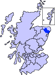
Map of Scotland showing the present-day committee area of Formartine

Formartine (Scottish Gaelic: Fearann Mhàrtainn meaning "Martin's land")[1] is a committee areainAberdeenshire, Scotland. This district extends north from the River Don to the River Ythan. It has a population of 36,478 (2001 Census).

The committee area was formed in 1996 from part of the former districtofBanff and Buchan.

Formartine has experienced rapid population growth, particularly around Ellon and Oldmeldrum, and in the south east where development has spread outwith the city of Aberdeen. By contrast, the area around Turriff retains strong dependency on the traditional agricultural economy. The area's coastline and rural environment offer recreation potential including the Formartine and Buchan Way.

History[edit]

Formartine is first documented as a thanage in 1266, when Reginald Cheyne is recorded holding it in feu-ferm and liable for 1412 merks as 2nd teinds payable to the Diocese of Aberdeen.[2] This would have valued the thanage in 1266 at £96 13s 4d, though by the time of the Alexander III rental this had increased to £106 13s 4d.[3]

The thanage's origins probably lay as one of the shires within the provinceofBuchan that paid tribute to the King of Alba rather than the Mormaer of Buchan.[4] The thanage had its main centre at Fyvie,[5] and it included a large royal forest for hunting.[6] Formartine lay between two areas within the Earldom of Buchan: Ellon to the north east, which was the caput of the earldom, and the detached area of Bethelnie (now Oldmeldrum) to the south west.[7]

Some time between 1292 and 1296 John de Balliol, then King of Scotland, alienated the thanage to John Comyn, Earl of Buchan, as compensation for Comyn's renunciation of his claim to part of the Lordship of Galloway, Balliol's ancestral lordship.[8] This effectively extended the bounds of the Earldom southward,[9] though the burgh and castle of Fyvie remained in crown hands.[10]

The thanage must later have been escheated and returned to crown hands, as between 1341 and 1346 David II granted half of Formartine to his sister Margaret and her husband William de Moravia, 5th Earl of Sutherland, and the other half to another of his sisters Matilda and her husband Thomas Isaac.[11] Formartine reverted again to the crown in 1373 on the death of the Earl of Sutherland, and was granted in 1377 to John, Earl of Carrick, the heir to the throne, and then in 1382 as a barony to James Lindsay, the son of David Lindsay of Crawford, and Carrick compensated with a £100 per year annuity.[12]The district has a long history.[13][14]

The early history of this locale is evidenced by the survival of a number of prehistoric features, including a number of tumuli.[15]

References[edit]

  1. ^ Mac an Tàilleir, Iain (2003). "Scottish Gaelic place names F-J" (PDF). Scottish Parliament. p. 50. Retrieved 19 December 2021.
  • ^ Grant 1993, pp. 55, 74.
  • ^ Grant 1993, p. 62.
  • ^ Broun 2015, pp. 52–53.
  • ^ Young 1993, pp. 184–185.
  • ^ Grant 1993, pp. 63–64.
  • ^ Young 1993, pp. 183–185.
  • ^ Grant 1993, pp. 69, 74.
  • ^ Young 1993, p. 185.
  • ^ Young 1993, pp. 197–198.
  • ^ Grant 1993, pp. 66–67.
  • ^ Grant 1993, p. 67, 74.
  • ^ Chalmers, George (1894). Caledonia: Or, A Historical and Topographical Account of North Britain, from the Most Ancient to the Present Times; with a Dictionary of Places, Chorographical and Philological. A. Gardner.
  • ^ Temple, William (1894). The Thanage of Fermartyn. Aberdeen: Wyllie. p. ix. Retrieved 3 April 2015.
  • ^ Hogan, C. Michael (2008). "Catto Long Barrow fieldnotes". The Modern Antiquarian. Retrieved 15 September 2009.
  • Bibliography[edit]

    Major districts (former counties, provincial lordships and rural deaneries)

  • Annandale
  • Angus
  • Argyll
  • Atholl
  • Boyne
  • Buchan
  • Badenoch
  • Breadalbane
  • Caithness
  • Carrick
  • Lanark (or Clydesdale)
  • Cowal
  • Cunningham
  • Desnes
  • Eskdale
  • Farines
  • Fife
  • Fothriff
  • Galloway
  • Garioch
  • Garmoran
  • The Glenkens
  • Gowrie
  • Kintyre
  • Knapdale
  • Kyle
  • Lauderdale
  • Lennox
  • Liddesdale
  • Lochaber
  • Lorn
  • Lothian
  • Marr
  • Mearns
  • Menteith
  • Merse
  • Moray
  • Nithsdale
  • The Rhinns
  • Ross (Easter and Wester)
  • Stormont
  • Strathavon
  • Strathbogie
  • Strathearn
  • Strathgryfe
  • Strathnaver
  • Strathspey
  • Sutherland
  • Teviotdale
  • Tweeddale
  • Minor districts

  • Appin
  • Ardgour
  • Ardmeanach
  • Ardnamurchan
  • Assynt
  • Avondale
  • Balquhidder
  • Benderloch
  • The Black Isle
  • Braemar
  • Coigach
  • Cromar
  • Cromdale
  • Douglasdale
  • Durness
  • Dùthaich MhicAoidh
  • Eddrachilles
  • Enzie
  • Ettrickdale
  • Ewesdale
  • Formartine
  • Gairloch
  • Glen Albyn
  • Glen Almond
  • Glen Cassley
  • Glen Clova
  • Glen Dochart
  • Glen Esk
  • Glen Lethnot
  • Glen Lyon
  • Glen Moriston
  • Glen Orchy
  • Glen Prosen
  • Glen Spean
  • Glen Urquhart
  • Glenelg
  • Glengarry
  • Glenshee
  • Gruinard
  • Howe of Fife
  • Howe of the Mearns
  • Kintail
  • Kintyre
  • Knoydart
  • Lochalsh
  • Loch Broom
  • Locheil
  • The Machars
  • Midmar
  • Moidart
  • Morar
  • Morvern
  • Muir of Ord
  • Rannoch Moor
  • Rhinns of Kells
  • Strath Gartney
  • Strath of Kildonan
  • Strath Oykel
  • Strath Tay
  • Strathallan
  • Strathardle
  • Strathbran
  • Strathbraan
  • Strathcarron (Forth)
  • Strathcarron (Oykel)
  • Strathconon
  • Strathdearn
  • Strathdeveron
  • Strathdee (Deeside)
  • Strathdon
  • Strathfarrar
  • Strathglass
  • Strathisla
  • Strathmore
  • Strathyre
  • Sunart
  • Trossachs
  • Insular districts
    For smaller islands, usually districts in their own right, see List of Scottish islands

  • Cumbrae
  • Islay

  • Rinns of Islay
  • Mull

  • Ross of Mull
  • Skye

  • Minginish
  • Sleat
  • Trotternish
  • Waternish
  • Outer Hebrides

    • Harris (North Harris, South Harris)
  • Lewis (The Lochs, West Side, Point, Back)
  • Orkney

  • Hoy and Walls
  • Rousay
  • Shapinsay
  • South Ronaldsay
  • Westray
  • Shetland

  • Fetlar
  • Unst
  • Whalsay
  • Yell
  • North Isles
  • Border areas

  • East March
  • Middle March
  • West March
  • Settlements and places of interest in Formartine, Aberdeenshire

    Primary settlements

  • Cuminestown
  • Ellon
  • Fyvie
  • Newburgh
  • Oldmeldrum
  • Pitmedden
  • Potterton
  • Rothienorman
  • Tarves
  • Turriff
  • Other settlements

  • Barthol Chapel
  • Belhelvie
  • Blackdog
  • Bogton
  • Cairnorrie
  • Collieston
  • Craigdam
  • Daviot
  • Foveran
  • Garmond
  • Gight
  • Gordonstown
  • Inverkeithny
  • Methlick
  • Udny Green
  • Udny Station
  • Whitecairns
  • Whiterashes
  • Woodhead of Fyvie
  • Ythanbank
  • Places of interest

  • Craigston Castle
  • Delgatie Castle
  • Esslemont Castle
  • Formartine and Buchan Way
  • Fyvie Castle
  • Haddo House
  • Knockhall Castle
  • Pitmedden Garden
  • Sands of Forvie
  • Tolquhon Castle
  • Ythan Estuary
  • Areas and primary settlements in Aberdeenshire
    (see also: Aberdeen City)

    inBanff and Buchan

  • Banff
  • Fraserburgh
  • Gardenstown
  • Inverallochy and Cairnbulg
  • Macduff
  • Portsoy
  • Rosehearty
  • Sandhaven
  • Whitehills
  • inBuchan

  • Crimond
  • Cruden Bay
  • Fetterangus
  • Hatton
  • Longside
  • Maud
  • Mintlaw
  • New Deer
  • New Pitsligo
  • Peterhead
  • St Combs
  • St Fergus
  • Strichen
  • Stuartfield
  • inFormartine

  • Cuminestown
  • Ellon
  • Fyvie
  • Newburgh
  • Oldmeldrum
  • Pitmedden
  • Potterton
  • Rothienorman
  • Tarves
  • Turriff
  • inGarioch

  • Insch
  • Inverurie
  • Kemnay
  • Kintore
  • Newmachar
  • Westhill
  • inKincardine and Mearns

  • Fettercairn
  • Gourdon
  • Inverbervie
  • Johnshaven
  • Laurencekirk
  • Luthermuir
  • Newtonhill
  • Portlethen
  • St Cyrus
  • Stonehaven
  • inMarr

  • Alford
  • Ballater
  • Banchory
  • Braemar
  • Huntly
  • Lumphanan
  • Tarland
  • Torphins
  • 57°23′46N 2°17′13W / 57.39611°N 2.28694°W / 57.39611; -2.28694


    Retrieved from "https://en.wikipedia.org/w/index.php?title=Formartine&oldid=1171552596"

    Categories: 
    Committee areas of Aberdeenshire
    Tumuli in Scotland
    Hidden categories: 
    Pages using gadget WikiMiniAtlas
    Articles with short description
    Short description is different from Wikidata
    Use dmy dates from November 2022
    Use British English from May 2013
    Articles containing Scottish Gaelic-language text
    Coordinates on Wikidata


    This page was last edited on 21 August 2023, at 20:36 (UTC).

    Text is available under the Creative Commons Attribution-ShareAlike License 4.0; additional terms may apply. By using this site, you agree to the Terms of Use and Privacy Policy. Wikipedia® is a registered trademark of the Wikimedia Foundation, Inc., a non-profit organization.


    Privacy policy

    About Wikipedia

    Disclaimers

    Contact Wikipedia

    Code of Conduct

    Developers

    Statistics

    Cookie statement

    Mobile view


    Wikimedia Foundation
    Powered by MediaWiki