Jump to content


Main menu


Navigation  


Main page
Contents
Current events
Random article
About Wikipedia
Contact us
Donate


Contribute  


Help
Learn to edit
Community portal
Recent changes
Upload file


Search  


Create account

Log in


Create account
 Log in


Pages for logged out editors learn more  


Contributions
Talk


Contents


(Top)


1 References  


2 External links  


Fort Reynolds (Colorado)


مصرى
 

Edit links


Article
Talk


Read
Edit
View history


Tools


Actions  


Read
Edit
View history


General  


What links here
Related changes
Upload file
Special pages
Permanent link
Page information
Cite this page
Get shortened URL
Download QR code
Wikidata item


Print/export  


Download as PDF
Printable version


Appearance


Coordinates: 38°1350.33N 104°1811.82W / 38.2306472°N 104.3032833°W / 38.2306472; -104.3032833
 

From Wikipedia, the free encyclopedia


Historical marker along Highway 50

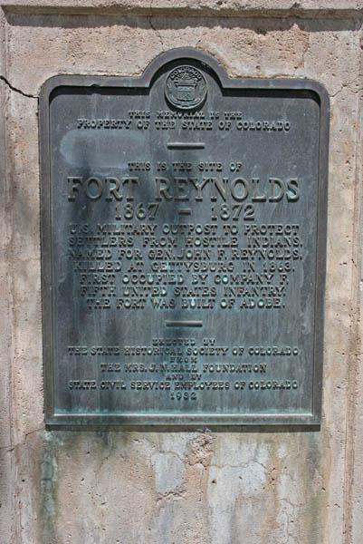
Fort Reynolds was a United States Army post near Avondale, Colorado during the Indian Wars and the Civil War.[1][2][3] The site is about 20 miles (32 km) east of Pueblo, Colorado.[2]

Construction began in 1867 on the 23 square mile fort, which was named for John F. Reynolds. He attended West Point and was killed at the Battle of Gettysburg.[2] Facilities included barracks, a mess hall, hospital, guardhouse, store-house, laundry, a corral, supply depot, and parade grounds.[2][4] Fort Lyon, which lies 60 miles (97 km) east of Fort Reynolds was closer to the skirmishes with Native Americans, so Fort Reynolds became a supply post, staffed with about 100 soldiers.[2] In January 1868, soldiers were called from Fort Lyon and Fort Reynolds to manage citizen unrest in Trinidad, Colorado that began with a drunken brawl. That was the extent of the action seen by the Fort Reynolds post. It closed in 1872.[2]

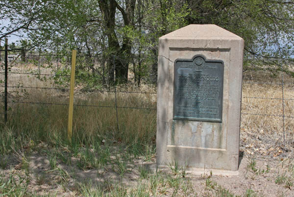
In the 1930s, the site had remnants of camp life, including cooking utensils, weapons, buttons, and other items.[1] A stone marker is located on US-50 at mile marker 333, about one mile east of Avondale.[2]

References

[edit]
  1. ^ a b Federal Writers' Project (October 31, 2013). The WPA Guide to Colorado: The Highest State. Trinity University Press. p. PT296. ISBN 978-1-59534-205-8.
  • ^ a b c d e f g Jolie Anderson Gallagher (April 2, 2013). Colorado Forts: Historic Outposts on the Wild Frontier. Arcadia Publishing Incorporated. p. PT113, other pages. ISBN 978-1-61423-903-1.
  • ^ U.S. Geological Survey Geographic Names Information System: Fort Reynolds (Colorado)
  • ^ United States. Quartermaster's Dept (1872). Outline Description of U.S. Military Posts and Stations in the Year 1871. U.S. Government Printing Office. p. 208, 264.
  • [edit]

    38°13′50.33″N 104°18′11.82″W / 38.2306472°N 104.3032833°W / 38.2306472; -104.3032833


    Retrieved from "https://en.wikipedia.org/w/index.php?title=Fort_Reynolds_(Colorado)&oldid=1180789138"

    Categories: 
    American Civil War army posts
    Forts in Colorado
    Military history of Colorado
    Government buildings completed in 1867
    Colorado in the American Civil War
    Native American history of Colorado
    Closed installations of the United States Army
    1867 establishments in Colorado Territory
    Hidden categories: 
    Pages using gadget WikiMiniAtlas
    Coordinates on Wikidata


    This page was last edited on 18 October 2023, at 21:08 (UTC).

    Text is available under the Creative Commons Attribution-ShareAlike License 4.0; additional terms may apply. By using this site, you agree to the Terms of Use and Privacy Policy. Wikipedia® is a registered trademark of the Wikimedia Foundation, Inc., a non-profit organization.


    Privacy policy

    About Wikipedia

    Disclaimers

    Contact Wikipedia

    Code of Conduct

    Developers

    Statistics

    Cookie statement

    Mobile view


    Wikimedia Foundation
    Powered by MediaWiki