Jump to content


Main menu


Navigation  


Main page
Contents
Current events
Random article
About Wikipedia
Contact us
Donate


Contribute  


Help
Learn to edit
Community portal
Recent changes
Upload file


Search  


Create account

Log in


Create account
 Log in


Pages for logged out editors learn more  


Contributions
Talk


Contents


(Top)


1 Economy  


2 References  


Fortul


 / Bân-lâm-gú
Cebuano
Deutsch
Español
فارسی
Français
Galego
Ilokano
Italiano

Bahasa Melayu
Nederlands
Polski
Português
Русский
Scots
Svenska
Tagalog
Tiếng Vit
Winaray


Edit links


Article
Talk


Read
Edit
View history


Tools


Actions  


Read
Edit
View history


General  


What links here
Related changes
Upload file
Special pages
Permanent link
Page information
Cite this page
Get shortened URL
Download QR code
Wikidata item


Print/export  


Download as PDF
Printable version


In other projects  


Wikimedia Commons


Appearance


Coordinates: 6°4732N 71°4632W / 6.79222°N 71.7756°W / 6.79222; -71.7756
 

From Wikipedia, the free encyclopedia


Fortul
Municipality and town
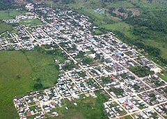
View of Fortul
View of Fortul
Flag of Fortul
Official seal of Fortul
Panorama of the urban area of Fortul Location of the municipality and town of Fortul in the Arauca Department of Colombia
Panorama of the urban area of Fortul
Location of the municipality and town of Fortul in the Arauca Department of Colombia
Coordinates: 6°47′35″N 71°46′17O
Country Colombia
DepartmentArauca Department
FoundedJanuary 7, 1920
Government
 • MayorLenin Pastrana Vergel[1]
Area
 • Total1,125 km2 (434 sq mi)
Elevation
246 m (807 ft)
Population
 (Census 2018[2])
 • Total17,492
Time zoneUTC-5 (Colombia Standard Time)
ClimateAm

Fortul is one of the seven municipalities of the Colombian department of Arauca. It limits to the north with Saravena; to the south with Tame; to the east with Arauquita and to the west with Güicán. It was founded on January 7, 1920. According to the census conducted by the DANE in 2005, Fortul has a population of 25,379 inhabitants, of which 13,081 live in the municipal seat making it 49.5% women and 50.5% men.[3][4]

Economy[edit]

The economic activities in the municipality are given by the sale of basic primary services and goods, as well as by some transformation of raw materials. The town has an organized trade of goods and consumption (stores, stores, restaurants, workshops, supplies and others). Three important activities in the town are livestock, agriculture, and the production of double cream cheese by some lactic micro-enterprises. The area of direct influence of the urban area on the territory is considered approximately 30% of its territory, since the neighboring municipalities, Arauquita, Tame and Saravena, cover the demand for services and remaining goods; thus, the urban dynamics of this town is very scarce as people from rural areas go to the villages.[5]

References[edit]

  • ^ "Censo Nacional de Población y Vivienda 2018" (in Spanish). Archived from the original on 13 August 2020. Retrieved 20 April 2020.
  • ^ "Alcaldia de Fortul, personal de la Alcaldia (In Spanish)". Archived from the original on 2018-06-27. Retrieved 2018-06-26.
  • ^ "Información general". www.fortul-arauca.gov.co (in European Spanish). Archived from the original on 2018-10-27. Retrieved 2018-10-26.
  • ^ "Boletín Censo General 2005" (PDF). 2010-09-10.
  • 6°47′32N 71°46′32W / 6.79222°N 71.7756°W / 6.79222; -71.7756


  • t
  • e

  • Retrieved from "https://en.wikipedia.org/w/index.php?title=Fortul&oldid=1096328420"

    Categories: 
    Municipalities of Arauca Department
    Orinoquía Region geography stubs
    Hidden categories: 
    All articles with bare URLs for citations
    Articles with bare URLs for citations from March 2022
    Articles with PDF format bare URLs for citations
    CS1 Spanish-language sources (es)
    CS1 European Spanish-language sources (es-es)
    Pages using gadget WikiMiniAtlas
    Articles with short description
    Short description is different from Wikidata
    Coordinates on Wikidata
    All stub articles


    This page was last edited on 3 July 2022, at 19:37 (UTC).

    Text is available under the Creative Commons Attribution-ShareAlike License 4.0; additional terms may apply. By using this site, you agree to the Terms of Use and Privacy Policy. Wikipedia® is a registered trademark of the Wikimedia Foundation, Inc., a non-profit organization.


    Privacy policy

    About Wikipedia

    Disclaimers

    Contact Wikipedia

    Code of Conduct

    Developers

    Statistics

    Cookie statement

    Mobile view


    Wikimedia Foundation
    Powered by MediaWiki