Jump to content


Main menu


Navigation  


Main page
Contents
Current events
Random article
About Wikipedia
Contact us
Donate


Contribute  


Help
Learn to edit
Community portal
Recent changes
Upload file


Search  


Create account

Log in


Create account
 Log in


Pages for logged out editors learn more  


Contributions
Talk


Contents


(Top)


1 History  


2 Geography  


3 References  


4 External links  


Four Mile, South Dakota


Add links


Article
Talk


Read
Edit
View history


Tools


Actions  


Read
Edit
View history


General  


What links here
Related changes
Upload file
Special pages
Permanent link
Page information
Cite this page
Get shortened URL
Download QR code
Wikidata item


Print/export  


Download as PDF
Printable version


Appearance


Coordinates: 43°4358N 103°4031W / 43.73278°N 103.67528°W / 43.73278; -103.67528
 

From Wikipedia, the free encyclopedia


Four Mile, South Dakota
Fourmile, Moss City
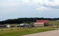
Looking southwest at Four Mile
Four Mile is located in South Dakota
Four Mile

Four Mile

Four Mile is located in the United States
Four Mile

Four Mile

Coordinates: 43°43′58N 103°40′31W / 43.73278°N 103.67528°W / 43.73278; -103.67528
CountryUnited States
StateSouth Dakota
CountyCuster
Elevation
5,361 ft (1,634 m)
Time zoneUTC-7 (MST)
 • Summer (DST)UTC-6 (MDT)
Area code605
GNIS feature ID1261691[1]
Four Mile
Map
Location
Roads at
junction
US 16 & CR 715 (Pleasant Valley Road)
Construction
Maintained bySouth Dakota Department of Transportation

Four Mile, historically called Moss City, is an unincorporated communityinCuster County, South Dakota, United States, located 4 miles (6.4 km) west of Custer at the junction of U.S. Route 16 and Pleasant Valley Road (County Highway 715).

Named because of the distance from Custer on the original Sidney Black Hills Stage Road, Four Mile today is a small bedroom community for Custer, with a single tourist attraction (the Four Mile Old West Town Museum), a log-cabin manufacturer, a small mobile home court, and several other residences.

History[edit]

Four Mile got its start as a stockade camp for General George Armstrong Custer's army in the 1870s. By 1876, it had a stagecoach stop; the stagecoach company named it such simply because it was 4 miles (6.4 km) from Custer. At the time, eight people lived there, but this number quickly grew. By 1890, about 100 people had moved to Four Mile, which was temporarily renamed Moss City. A jail, store, and saloon were built.[2]

Gold dredging took place sporadically on the nearby Four Mile Creek, in 1898 and again in 1933, but these efforts were unsuccessful. At the beginning of the 20th century, Moss City reverted to its old name of Four Mile as the population began to decline. Today, only a few buildings from the original townsite remain; others were recreated for the 1994 opening of the Four Mile Old West Town Museum.[2]

Geography[edit]

Four Mile is located at the junction of U.S. Route 16 and County Road 715 (also known as Pleasant Valley Road) in rural Custer County, South Dakota, in the Black Hills.

References[edit]

  1. ^ "US Board on Geographic Names". United States Geological Survey. October 25, 2007. Retrieved January 31, 2008.
  • ^ a b Raisch, Bruce A. (2006). "South Dakota Black Hills Ghost Towns". Ghost Towns and Other Historical Sites of the Black Hills (4th ed.). Virginia Beach, Virginia: Donning Company Publishers. pp. 42–44. ISBN 978-1-57864-351-6.
  • External links[edit]


  • t
  • e

  • Retrieved from "https://en.wikipedia.org/w/index.php?title=Four_Mile,_South_Dakota&oldid=1212215163"

    Categories: 
    Unincorporated communities in Custer County, South Dakota
    Black Hills
    1876 establishments in Dakota Territory
    Populated places established in 1876
    South Dakota geography stubs
    Hidden categories: 
    Pages using gadget WikiMiniAtlas
    Use mdy dates from July 2023
    Articles with short description
    Short description is different from Wikidata
    Coordinates on Wikidata
    Infobox mapframe without OSM relation ID on Wikidata
    Official website not in Wikidata
    All stub articles
    Pages using the Kartographer extension


    This page was last edited on 6 March 2024, at 18:15 (UTC).

    Text is available under the Creative Commons Attribution-ShareAlike License 4.0; additional terms may apply. By using this site, you agree to the Terms of Use and Privacy Policy. Wikipedia® is a registered trademark of the Wikimedia Foundation, Inc., a non-profit organization.


    Privacy policy

    About Wikipedia

    Disclaimers

    Contact Wikipedia

    Code of Conduct

    Developers

    Statistics

    Cookie statement

    Mobile view


    Wikimedia Foundation
    Powered by MediaWiki