Jump to content


Main menu


Navigation  


Main page
Contents
Current events
Random article
About Wikipedia
Contact us
Donate


Contribute  


Help
Learn to edit
Community portal
Recent changes
Upload file


Search  


Create account

Log in


Create account
 Log in


Pages for logged out editors learn more  


Contributions
Talk


Contents


(Top)


1 Boundary marker  


2 2022 restoration  


3 See also  


4 References  


5 External links  


Four Shire Stone


Add links


Article
Talk


Read
Edit
View history


Tools


Actions  


Read
Edit
View history


General  


What links here
Related changes
Upload file
Special pages
Permanent link
Page information
Cite this page
Get shortened URL
Download QR code
Wikidata item


Print/export  


Download as PDF
Printable version


In other projects  


Wikimedia Commons


Appearance


Coordinates: 51°5915N 1°3957W / 51.98750°N 1.66583°W / 51.98750; -1.66583 (Four Shire Stone)
 

From Wikipedia, the free encyclopedia


The Four Shire Stone

The Four Shire Stone is a boundary marker that marks the point where the English countiesofWarwickshire, Oxfordshire, Gloucestershire, and Worcestershire once met. Since 1931, when the Worcestershire exclave of Evenlode was transferred to Gloucestershire, only three counties have met at the stone.[1]

Boundary marker

[edit]
Detail from Wenceslaus Hollar's An Orthographical Designe of Several Views Upon Ye Road, in England and Wales (1660)[2]
Detail from Joan Blaeu's map of Gloucestershire (1662), showing the "Shire Stones"

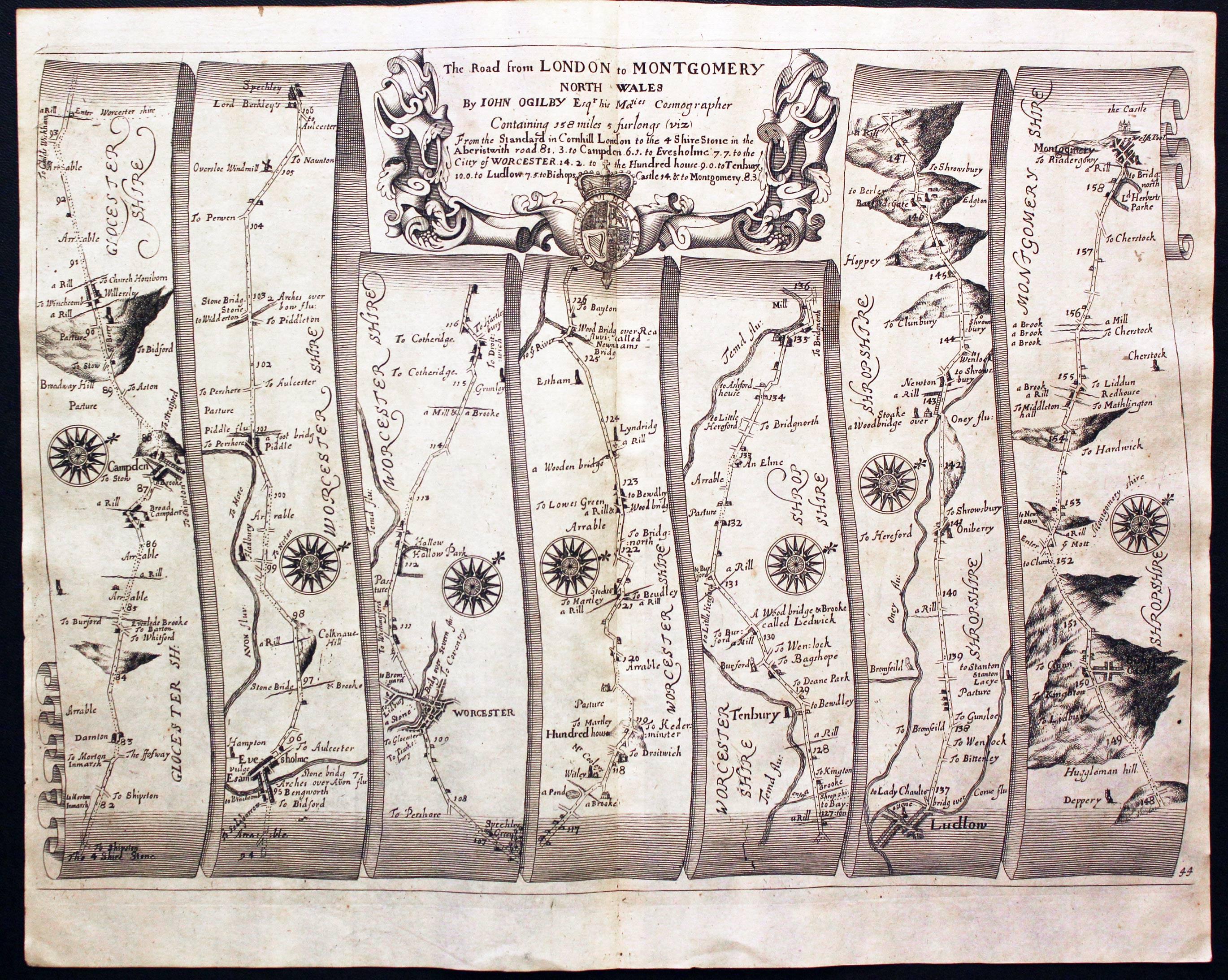
The Four Shire Stone is not a single stone, but a nine-foot high monument, built from the local Cotswold stone. It is in the English midlands at the northern corner of a T junction on the A44 road, a mile and a half east of the small town of Moreton-in-Marsh (which has the closest railway station), at 51°59′15N 1°39′57W / 51.98750°N 1.66583°W / 51.98750; -1.66583 (Four Shire Stone), grid reference SP2301432023. The existing structure was probably built in the 18th century, and is a grade II listed building.[3] There was an earlier "4 Shire Stone" on or near the site in 1675, almost certainly that illustrated in 1660.[4][5] Thomas Habington's Survey of Worcestershire mentions "the stone which toucheth four sheeres, a thing rarely scene".[6]

Five (formerly seven) civil parishes meet at the stone:[7]

The J. R. R. Tolkien Society claims that the Four Shire Stone inspired the "Three-Farthing Stone" in J. R. R. Tolkien's book The Lord of the Rings. In that work, the Shire, the homeland of the hobbits is divided into four farthings, three of which meet at the "Three-Farthing Stone".[10][11]

2022 restoration

[edit]

The failing state of this unique bit of local history inspired James Hayman-Joyce, a local, semi-retired chartered surveyor, to do what he could to restore it. He formed the Four Shire Stone Restoration Committee with the aim of raising £20,000 to restore the Four Shire Stone to its former glory. The project comprises restoring and repairing the stonework, replacing the railings and enhancing the engravings on all four sides of the pillar.[12]

See also

[edit]

References

[edit]
  1. ^ "The Four Shire Stone Moreton-in-Marsh". Retrieved 12 August 2013.
  • ^ British Library (24 August 2020), The BL King's Topographical Collection: "An Orthographical Designe of Several Views Upon Ye Road, in England and Wales", retrieved 7 March 2021
  • ^ "Four Shire Stone, British Listed Buildings". Retrieved 8 May 2018.
  • ^ Ogilby, John (1675). Britannia Atlas. Richard Nicholson of Chester, map dealer. p. Plate 44. Retrieved 1 October 2013.
  • ^ Library, British (24 August 2020), The BL King's Topographical Collection: "An Orthographical Designe of Several Views Upon Ye Road, in England and Wales. ", retrieved 7 March 2021
  • ^ Abingdon, Thomas (1897). "Evenlode". In Amphlett, John (ed.). A survey of Worcestershire. Vol. 2 Pt.2. Oxford: James Parker for the Worcestershire Historical Society. p. 68.
  • ^ "Gloucestershire". Ordnance Survey Miscellaneous Boundary Maps. Vision of Britain. 1967. Retrieved 3 May 2018.; "Oxfordshire". Ordnance Survey Miscellaneous Boundary Maps. Vision of Britain. 1966. Retrieved 3 May 2018.; "Warwickshire". Ordnance Survey Maps of England and Wales. Vision of Britain. 1900. Retrieved 3 May 2018.
  • ^ "The Cotswold (Parishes) Order 1986" (PDF).
  • ^ "Gloucestershire". Ordnance Survey Sanitary Districts, showing Civil Parishes. Vision of Britain. 1888. Retrieved 3 May 2018.; Elrington, C. R., ed. (1965). "Parishes: Lower Lemington". Gloucester. Victoria County History. Vol. 6. London: British History Online. pp. 216–220. Retrieved 4 May 2018.
  • ^ "Moreton-in-Marsh Tourist Information and Travel Guide". cotswolds.info. Retrieved 12 August 2013.
  • ^ Hooker, Mark T. (2009). The Hobbitonian Anthology. Llyfrawr. pp. 98–99. ISBN 978-1448617012.
  • ^ "Four Shire Stone Restoration Project". Retrieved 6 April 2022.
  • [edit]
    Retrieved from "https://en.wikipedia.org/w/index.php?title=Four_Shire_Stone&oldid=1229385893"

    Categories: 
    Boundary markers
    Quadripoints and higher
    Cotswold District
    West Oxfordshire District
    Stratford-on-Avon District
    History of Worcestershire
    Monuments and memorials in Gloucestershire
    Grade II listed buildings in Gloucestershire
    Monuments and memorials in Oxfordshire
    Grade II listed buildings in Oxfordshire
    Monuments and memorials in Warwickshire
    Grade II listed buildings in Warwickshire
    18th-century architecture in the United Kingdom
    Monumental columns in the United Kingdom
    Moreton-in-Marsh
    Geography of Warwickshire
    Geography of Oxfordshire
    Geography of Gloucestershire
    Geography of Worcestershire
    Hidden categories: 
    Pages using gadget WikiMiniAtlas
    CS1: long volume value
    Articles with short description
    Short description is different from Wikidata
    Use dmy dates from April 2022
    Coordinates on Wikidata


    This page was last edited on 16 June 2024, at 14:23 (UTC).

    Text is available under the Creative Commons Attribution-ShareAlike License 4.0; additional terms may apply. By using this site, you agree to the Terms of Use and Privacy Policy. Wikipedia® is a registered trademark of the Wikimedia Foundation, Inc., a non-profit organization.


    Privacy policy

    About Wikipedia

    Disclaimers

    Contact Wikipedia

    Code of Conduct

    Developers

    Statistics

    Cookie statement

    Mobile view


    Wikimedia Foundation
    Powered by MediaWiki