Jump to content


Main menu


Navigation  


Main page
Contents
Current events
Random article
About Wikipedia
Contact us
Donate


Contribute  


Help
Learn to edit
Community portal
Recent changes
Upload file


Search  


Create account

Log in


Create account
 Log in


Pages for logged out editors learn more  


Contributions
Talk


Contents


(Top)


1 Geography  


2 History  


3 References  


Fox's Gap


Add links


Article
Talk


Read
Edit
View history


Tools


Actions  


Read
Edit
View history


General  


What links here
Related changes
Upload file
Special pages
Permanent link
Page information
Cite this page
Get shortened URL
Download QR code
Wikidata item


Print/export  


Download as PDF
Printable version


Appearance


Coordinates: 39°2815N 77°3702W / 39.47076°N 77.61715°W / 39.47076; -77.61715
 

From Wikipedia, the free encyclopedia


Fox's Gap
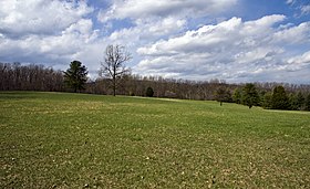
Fox's Gap looking northeast towards Turner's Gap
Elevation1,060 ft (323 m)
LocationMaryland, United States
RangeBlue Ridge Mountains
South Mountain
Coordinates39°28′15N 77°37′02W / 39.47076°N 77.61715°W / 39.47076; -77.61715
Fox's Gap is located in Maryland
Fox's Gap

Fox's Gap

Fox's Gap, also known as Fox Gap, is a wind gap in the South Mountain Range of the Blue Ridge Mountains, located in Frederick County and Washington County, Maryland. The gap is traversed by Reno Monument Road. The Appalachian Trail also crosses the gap along the ridgeline.[1]

Geography

[edit]

The gap is about 200 feet (61 m) below the ridge line to the north, 400 feet (120 m) below the ridge line to the south and about 400 feet (120 m) above the surrounding lowlands. To the east of the gap lies the Middletown Valley and to the west the Hagerstown Valley. Turner's Gap is 1 mile (1.6 km) to the north, while Lambs Knoll is immediately to the south.

History

[edit]

The area was settled in early 1751 by the John and Christiana Fox family and their son Frederick, German immigrants from Hesse.[2] Frederick assembled adjoining lands which eventually extended to Turner's Gap. The area is first mentioned as "Foxes Gap" in a September 10, 1792, letter. Frederick Fox moved to Ohio in the early 1800s after the death of his wife.[3] Fox's gap was in use by Euromerican colonists for decades before anyone settled there on the slopes of the mountain or gave it a lasting name.[4] This was the original, early route of what would be known as The Great Philadelphia Wagon Road. John MacGruder's 1732 patent along Catoctin Creek is described as “about 1/2 mile above the wagon road that goes from Connestoga to Opeckon[5] indicating the road being well established by that early date. The main migration wagon road would eventually be relocated to the center of the valley, but the Middletown to Sharpsburg route would remain in use as a local road over essentially the same roadbeds from the 1730s until present. General Braddock, George Washington, and Dunbar's Regiment went through Fox's Gap during May 1755 in the Braddock Expedition and their attempt to capture Fort Duquesne.[6]

The Daniel Wise family bought a portion of the property in 1858 for $46.96, clearing fields and building a log cabin.[7] The Wise House was demolished in 1919. On September 14, 1862, the area was the scene some of the heaviest engagements of the Battle of South Mountain. [8] The Reno Monument erected in 1889 by fellow soldiers at the top of Fox's Gap along Reno Monument Road commemorates the death of Union general Jesse L. Reno.[3] Another monument has been erected nearby in the 1990s, which commemorates also the death of Confederate Brig. General Samuel Garland, Jr. and about a half-mile south is a bronze sculpture on a granite stone base dedicated in 2003 to remember the North Carolina troops that held the line here.

The area is listed on the National Register of Historic Places as part of the Turner's and Fox's Gaps Historic District.[9]

References

[edit]
  1. ^ "Fox Gap". Geographic Names Information System. United States Geological Survey, United States Department of the Interior. Retrieved 2018-10-23.
  • ^ Older, Curtis L., News from Fox's Gap, Heritage Books, Inc., ISBN 978-0-7884-5842-2.
  • ^ a b "History of Fox Gap, Maryland". A Gap in Time: The Wise Farmstead/Fox Gap Archaeological Project. Archeological Services Program, Indiana University of Pennsylvania. Archived from the original on 23 July 2008. Retrieved 1 April 2011.
  • ^ Older, Curtis (2009). The Braddock Expedition and Fox's Gap in Maryland. Heritage Books. ISBN 9781585493012.
  • ^ Ellis (2017). Braddock's Neglected Route. p. 9. ISBN 9780998833002.
  • ^ Older, Curtis L., The Braddock Expedition and Fox's Gap in Maryland, Heritage Books, Kindle, and Apple Books.
  • ^ Older, Curtis L., The Land Tracts of the Battlefield of South Mountain, Heritage Books, Inc., ISBN 1-58549-066-0.
  • ^ Older, Curtis L., Hood's Defeat Near Fox's Gap September 14, 1862, Kindle and Apple Books, ISBN 978-0-9960067-5-0.
  • ^ "National Register Information System". National Register of Historic Places. National Park Service. April 15, 2008.

  • Retrieved from "https://en.wikipedia.org/w/index.php?title=Fox%27s_Gap&oldid=1220061633"

    Categories: 
    Valleys of Maryland
    Wind gaps of the United States
    South Mountain Range (MarylandPennsylvania)
    Landforms of Frederick County, Maryland
    Landforms of Washington County, Maryland
    Appalachian Trail
    Journey Through Hallowed Ground National Heritage Area
    Hidden categories: 
    Pages using gadget WikiMiniAtlas
    Articles using NRISref without a reference number
    Articles with short description
    Short description matches Wikidata
    Coordinates on Wikidata


    This page was last edited on 21 April 2024, at 16:09 (UTC).

    Text is available under the Creative Commons Attribution-ShareAlike License 4.0; additional terms may apply. By using this site, you agree to the Terms of Use and Privacy Policy. Wikipedia® is a registered trademark of the Wikimedia Foundation, Inc., a non-profit organization.


    Privacy policy

    About Wikipedia

    Disclaimers

    Contact Wikipedia

    Code of Conduct

    Developers

    Statistics

    Cookie statement

    Mobile view


    Wikimedia Foundation
    Powered by MediaWiki