
Frankenblick
| |
|---|---|

Town hall
| |

Coat of arms | |
Location of Frankenblick within Sonneberg district 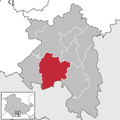 | |
 Frankenblick Show map of Germany  Frankenblick Show map of Thuringia | |
| Coordinates: 50°22′N 11°4′E / 50.367°N 11.067°E / 50.367; 11.067 | |
| Country | Germany |
| State | Thuringia |
| District | Sonneberg |
| Government | |
| • Mayor (2019–25) | Ute Müller-Gothe[1] (CDU) |
| Area | |
| • Total | 60.65 km2 (23.42 sq mi) |
| Elevation | 395 m (1,296 ft) |
| Population
(2022-12-31)[2]
| |
| • Total | 5,617 |
| • Density | 93/km2 (240/sq mi) |
| Time zone | UTC+01:00 (CET) |
| • Summer (DST) | UTC+02:00 (CEST) |
| Postal codes |
96528
|
| Dialling codes | 03675, 036766 |
| Vehicle registration | SON, NH |
| Website | www |
Frankenblick is a municipality in the Sonneberg district of Thuringia, Germany.
Frankenblick was formed on 1 January 2012 by the merger of the former municipalities Effelder-Rauenstein and Mengersgereuth-Hämmern. Today, it consists of the districts Effelder, Rauenstein, Grümpen, Seltendorf, Rabenäußig, Rückerswind, Meschenbach, Döhlau and Mengersgereuth-Hämmern.[3]


|
Towns and municipalities in Sonneberg (district)
| ||
|---|---|---|
|
| |
| International |
|
|---|---|
| National |
|
| Geographic |
|
This Sonneberg district location article is a stub. You can help Wikipedia by expanding it. |