Jump to content


Main menu


Navigation  


Main page
Contents
Current events
Random article
About Wikipedia
Contact us
Donate


Contribute  


Help
Learn to edit
Community portal
Recent changes
Upload file


Search  


Create account

Log in


Create account
 Log in


Pages for logged out editors learn more  


Contributions
Talk


Contents


(Top)


1 See also  


2 References  


3 External links  


French Creek (Schuylkill River tributary)


Add links


Article
Talk


Read
Edit
View history


Tools


Actions  


Read
Edit
View history


General  


What links here
Related changes
Upload file
Special pages
Permanent link
Page information
Cite this page
Get shortened URL
Download QR code
Wikidata item


Print/export  


Download as PDF
Printable version


In other projects  


Wikimedia Commons


Appearance


Coordinates: 40°0811N 75°3036W / 40.1363°N 75.5101°W / 40.1363; -75.5101
 

From Wikipedia, the free encyclopedia


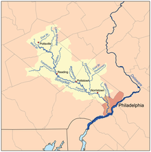
Schuylkill River watershed. French Creek joins the Schuylkill River between Pottstown and Norristown in the map.

French Creek, once known as Saukanac Creek,[1] is a 22.6-mile-long (36.4 km) tributary of the Schuylkill RiverinBerks and Chester counties, Pennsylvania, in the United States.[2] The water course was also known as the Vincent River, after Sir Mathias Vincent, who purchased land (now West and East Vincent Townships) along it in Chester County in 1686.[3]

French Creek travels through the Hopewell Big Woods, including French Creek State Park, and joins the Schuylkill in Phoenixville. French Creek is a designated Pennsylvania Scenic River.

The French Creek valley was an important early industrial region, particularly iron, in the United States. Hopewell Furnace National Historic Site along French Creek interprets this history. The Phoenix Iron Works site in Phoenixville, an active iron and steel producer from colonial times until the late 20th century, sits astride the creek just before it joins the Schuylkill.

In 1994, the Green Valleys Association (GVA) with its 38 co-petitioners filed a petition with the Pennsylvania Environmental Quality Board for the upgrade of the French Creek watershed from a designation of High Quality (HQ) to Exceptional Value (EV). In September 1998, the French Creek watershed west of PA 100 and the Birch Run watershed were granted this upgrade. In 2003, Green Valleys and its 48 co-petitioners successfully filed a petition to obtain an upgrade from HQ to EV of the lower reaches of French Creek, from the Kennedy Covered Bridge in East Vincent and East Pikeland Townships upstream to PA 100 in South Coventry Township as well as the entire Beaver Run. This petition was accepted by the Environmental Quality Board in February 2004 and is currently being reviewed.

See also[edit]

References[edit]

  1. ^ The Phoenix Bridge Company (1885). Album of designs of the Phoenix Bridge Company : successors to Clarke, Reeves & Co., Phoenixville Bridge Works. Philadelphia: J.B. Lippincott & Company. p. 15.
  • ^ U.S. Geological Survey. National Hydrography Dataset high-resolution flowline data. The National Map Archived 2012-03-29 at the Wayback Machine, accessed April 1, 2011
  • ^ "VINCENT TOWNSHIP (Including East & West)". Retrieved 21 September 2014.
  • External links[edit]

    40°08′11N 75°30′36W / 40.1363°N 75.5101°W / 40.1363; -75.5101


    Retrieved from "https://en.wikipedia.org/w/index.php?title=French_Creek_(Schuylkill_River_tributary)&oldid=1178185546"

    Categories: 
    Rivers of Pennsylvania
    Tributaries of the Schuylkill River
    Rivers of Berks County, Pennsylvania
    Rivers of Chester County, Pennsylvania
    Scenic Rivers of Pennsylvania
    Protected areas of Berks County, Pennsylvania
    Protected areas of Chester County, Pennsylvania
    Hidden categories: 
    Webarchive template wayback links
    Pages using gadget WikiMiniAtlas
    Articles needing additional references from March 2014
    All articles needing additional references
    Coordinates on Wikidata
    Articles with J9U identifiers
    Articles with LCCN identifiers


    This page was last edited on 2 October 2023, at 02:13 (UTC).

    Text is available under the Creative Commons Attribution-ShareAlike License 4.0; additional terms may apply. By using this site, you agree to the Terms of Use and Privacy Policy. Wikipedia® is a registered trademark of the Wikimedia Foundation, Inc., a non-profit organization.


    Privacy policy

    About Wikipedia

    Disclaimers

    Contact Wikipedia

    Code of Conduct

    Developers

    Statistics

    Cookie statement

    Mobile view


    Wikimedia Foundation
    Powered by MediaWiki