
Gangni
গাংনী
| |
|---|---|

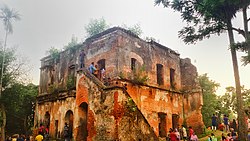
Bhatpara Neelkuthi
| |
 | |
| Coordinates: 23°49′N 88°45.3′E / 23.817°N 88.7550°E / 23.817; 88.7550 | |
| Country | |
| Division | Khulna |
| District | Meherpur |
| Area | |
| • Total | 341.98 km2 (132.04 sq mi) |
| Population
(2011)
| |
| • Total | 299,607 |
| • Density | 880/km2 (2,300/sq mi) |
| Time zone | UTC+6 (BST) |
| Website | Official Website |
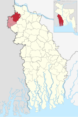
Gangni (Bengali: গাংনী) is an upazilaofMeherpur District[1] in the Division of Khulna, Bangladesh.
It has 77,580 households and total area 341.98 km2.
Main rivers are Bhairab, Kazla. Dharla and Ilangi Beels are notable. Gangni (town) consists of 5 mouzas. It has a population of 19126; male 51.48% and female 48.95%. Literacy rate among the town people is 28.8%. Administration Gangni thana, now an upazila, was established in 1923. It consists of 9 union parishads, 100 mouzas, 136 village, 5 border outpost.
Gangni Upazila is bounded by Daulatpur Upazila in Kushtia District, on the north, Daulatpur, Mirpur Upazilas in Kushtia District, and Alamdanga Upazila in Chuadanga District on the east, Alamdanga Upazila in Chuadanga District and Meherpur Sadar Upazila in Meherpur District, on the south and Karimpur II and Tehatta I CD Blocks, in Nadia District, West Bengal, India, on the west.[2][3]
| Religions in Gangni upazila (2011)[4] | ||||
|---|---|---|---|---|
| Religion | Percent | |||
| Islam |
|
98.62% | ||
| Hinduism |
|
0.91% | ||
| Christianity |
|
0.44% | ||
| Other or not stated |
|
0.03% | ||
As of the 2011 Bangladesh census, Gangni upazila had 77,580 households and a population of 299,607. 57,199 (19.09%) were under 10 years of age. Gangni had a literacy rate of 42.21%, compared to the national average of 51.8%, and a sex ratio of 1021 females per 1000 males. 30,239 (10.09%) of the population lived in urban areas.[4][5]
At the 1991 Bangladesh census, Gangni had a population of 229,138, of whom 117,027 were aged 18 or older. Males constituted 51.05% of the population, and females 48.95%. Gangni had a literacy rate of 21% (7+ years), against the national average of 32.4%.[6]
Public library 4, rural club 10, playground 20. Main occupations Agriculture 38.19%, agricultural labourer 33.75%, wage labourer 4.43%, commerce 12.48%, construction 1%, service 2.7%, others 7.45%.Land use Cultivable land 26.545 hectare; fallow land 38 hectare; single crop 13.4%, double crop 67.5%, triple crop 19.2%; land under irrigation 54%.Land control Among the peasants, 14.29% are rich, 50.79% intermediate and 34.92% small; cultivable land per head 0.15 hectare.,
Football is a popular sports for the people in the upazila, young generation is attracted by the cricket. Men wear Lungi whether women prefer Sari.
Shaharbati Neelkuthi (1859) and Gosaidubi Mosque at Karamdi. Marks of War of Liberation Mass grave 2 (Kazipur and Tepukhali playground). There is a hundred of ponds at the village Sholotaka where fish is cultivated commercially
Gangni Upazila is divided into Gangni Municipality and nine union parishads: Bamondi, Dhankolla, Kathuli, Kazipur, Motmura, Raipur, Shaharbati, Sholotaka, and Tentulbaria. The union parishads are subdivided into 90 mauzas and 137 villages.[4]
Gangni Municipality is subdivided into 9 wards and 29 mahallas.[4]
Old educational institutions are Hoglabaria High School and Gangni High School.
|
| ||
|---|---|---|
| Upazilas |
| |
| Constituencies |
| |
| Attractions and sites |
| |
| Rivers |
| |
| Inhabited areas |
| |
| Educational institutions |
| |
| History |
| |