Jump to content


Main menu


Navigation  


Main page
Contents
Current events
Random article
About Wikipedia
Contact us
Donate


Contribute  


Help
Learn to edit
Community portal
Recent changes
Upload file


Search  


Create account

Log in


Create account
 Log in


Pages for logged out editors learn more  


Contributions
Talk


Contents


(Top)


1 History  


2 Geography  


2.1  Barangays  


2.2  Climate  


3 Demographics  


4 Economy  


5 References  


6 External links  


Garchitorena


Bikol Central
Cebuano
Chavacano de Zamboanga
Deutsch
Español
Euskara
Français
Bahasa Hulontalo
Ilokano
Bahasa Indonesia
Italiano
Kapampangan

Bahasa Melayu
Nederlands
Pangasinan
Português
Svenska
Tagalog
Winaray
 

Edit links


Article
Talk


Read
Edit
View history


Tools


Actions  


Read
Edit
View history


General  


What links here
Related changes
Upload file
Special pages
Permanent link
Page information
Cite this page
Get shortened URL
Download QR code
Wikidata item


Print/export  


Download as PDF
Printable version


In other projects  


Wikimedia Commons


Appearance


Coordinates: 13°53N 123°42E / 13.88°N 123.7°E / 13.88; 123.7
 

From Wikipedia, the free encyclopedia


Garchitorena
Municipality of Garchitorena
Flag of Garchitorena
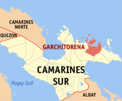
Map of Camarines Sur with Garchitorena highlighted
OpenStreetMap
Map
Garchitorena is located in Philippines
Garchitorena

Garchitorena

Location within the Philippines

Coordinates: 13°53′N 123°42′E / 13.88°N 123.7°E / 13.88; 123.7
CountryPhilippines
RegionBicol Region
ProvinceCamarines Sur
District 4th district
FoundedMarch 4, 1949
Named forAndres Garchitorena
Barangays23 (see Barangays)
Government
[1]
 • TypeSangguniang Bayan
 • MayorLeda S. San Luis
 • Vice MayorMarcelo S. Aragdon
 • RepresentativeArnulf Bryan B. Fuentebella
 • Municipal Council

Members

 • Electorate18,388 voters (2022)
Area
 • Total243.80 km2 (94.13 sq mi)
Elevation
30 m (100 ft)
Highest elevation
317 m (1,040 ft)
Lowest elevation
0 m (0 ft)
Population
 (2020 census)[3]
 • Total29,436
 • Density120/km2 (310/sq mi)
 • Households
6,013
Economy
 • Income class4th municipal income class
 • Poverty incidence

53.25 % (2021)[4]
 • Revenue₱ 169.4 million (2020)
 • Assets₱ 394.4 million (2020)
 • Expenditure₱ 131.8 million (2020)
 • Liabilities₱ 77.27 million (2020)
Service provider
 • ElectricityCamarines Sur 4 Electric Cooperative (CASURECO 4)
Time zoneUTC+8 (PST)
ZIP code
4428
PSGC
IDD:area code+63 (0)54
Native languagesCentral Bikol
Tagalog

Garchitorena, officially the Municipality of Garchitorena (Central Bikol: Banwaan kan Garchitorena; Tagalog: Bayan ng Garchitorena), is a 4th class municipality in the provinceofCamarines Sur, Philippines. According to the 2020 census, it has a population of 29,436 people.[3]

Its territory includes the islands of Quinalasag, Lamit, and Malabungot, also known as Mahad.

History

[edit]

The original location of Garchitorena is said to be found at the mouth of the Pambuhan River but it was later transferred to Binanwahan primarily because of frequent attacks of the Moros.

Soon, a rich man by the name of Don Andres Garchitorena, who hailed from Tigaon town and owned in this place a vast portion of the land area, persuaded the townspeople to plant abaca. He later established an abaca processing plant which started the establishment of this coastal settlement.

The municipality was established on March 4, 1949, through Executive Order No. 205 signed by President Elpidio Quirino. It was originally named the municipality of Anderson.[5] The municipality was then renamed after its founder and discoverer, Don Andres Garchitorena. He came from Tigaon. He was a member of Emilio Aguinaldo's Hong Kong Junta during the Spanish–American War. He became the governor of then Ambos Camarines in 1919. He is the father of Don Mariano Garchitorena, Secretary of Agriculture and Commerce and also Governor of Camarines Sur.

Geography

[edit]

Barangays

[edit]

Garchitorena is politically subdivided into 23 barangays. Each barangay consists of puroks and some have sitios.

  • Ason (Anson)
  • Bahi
  • Binagasbasan
  • Burabod
  • Cagamutan
  • Cagnipa
  • Canlong
  • Dangla
  • Del Pilar
  • Denrica
  • Harrison
  • Mansangat
  • Pambuhan
  • Barangay I (Poblacion)
  • Barangay II (Poblacion)
  • Barangay III (Poblacion)
  • Barangay IV (Poblacion)
  • Sagrada
  • Salvacion
  • San Vicente
  • Sumaoy
  • Tamiawon
  • Toytoy
  • Climate

    [edit]
    Climate data for Garchitorena, Camarines Sur
    Month Jan Feb Mar Apr May Jun Jul Aug Sep Oct Nov Dec Year
    Mean daily maximum °C (°F) 30
    (86)
    30
    (86)
    32
    (90)
    33
    (91)
    35
    (95)
    35
    (95)
    35
    (95)
    34
    (93)
    35
    (95)
    33
    (91)
    31
    (88)
    31
    (88)
    33
    (91)
    Mean daily minimum °C (°F) 27
    (81)
    27
    (81)
    28
    (82)
    30
    (86)
    31
    (88)
    31
    (88)
    31
    (88)
    30
    (86)
    30
    (86)
    29
    (84)
    28
    (82)
    28
    (82)
    29
    (85)
    Average precipitation mm (inches) 151.1
    (5.95)
    198.89
    (7.83)
    106.28
    (4.18)
    60.08
    (2.37)
    63.62
    (2.50)
    85.76
    (3.38)
    117.53
    (4.63)
    46.99
    (1.85)
    52.23
    (2.06)
    740.22
    (29.14)
    522.7
    (20.58)
    618.0
    (24.33)
    2,763.4
    (108.8)
    Average rainy days 24 28 18 23 23 25 29 21 26 28 29 31 305
    Source: World Weather Online[6]

    Demographics

    [edit]
    Population census of Garchitorena
    YearPop.±% p.a.
    1960 10,191—    
    1970 15,890+4.54%
    1975 16,438+0.68%
    1980 16,877+0.53%
    1990 19,439+1.42%
    1995 19,481+0.04%
    2000 23,021+3.64%
    2007 24,825+1.05%
    2010 25,204+0.55%
    2015 27,010+1.33%
    2020 29,436+1.71%
    Source: Philippine Statistics Authority[7][8][9][10]

    In the 2020 census, the population of Garchitorena was 29,436 people,[3] with a density of 120 inhabitants per square kilometre or 310 inhabitants per square mile.

    Bikol is the predominant language spoken.

    Economy

    [edit]

    Poverty incidence of Garchitorena

    10

    20

    30

    40

    50

    60

    2006
    58.40

    2009
    58.97

    2012
    56.06

    2015
    59.74

    2018
    41.16

    2021
    53.25

    Source: Philippine Statistics Authority[11][12][13][14][15][16][17][18]

    Local agricultural products in the town includes abaca, coconut, and palay. Electrical power is supplied by CASURECO (Camarines Sur Electric Cooperative).

    References

    [edit]
  • ^ "2015 Census of Population, Report No. 3 – Population, Land Area, and Population Density" (PDF). Philippine Statistics Authority. Quezon City, Philippines. August 2016. ISSN 0117-1453. Archived (PDF) from the original on May 25, 2021. Retrieved July 16, 2021.
  • ^ a b c Census of Population (2020). "Region V (Bicol Region)". Total Population by Province, City, Municipality and Barangay. Philippine Statistics Authority. Retrieved 8 July 2021.
  • ^ "PSA Releases the 2021 City and Municipal Level Poverty Estimates". Philippine Statistics Authority. 2 April 2024. Retrieved 28 April 2024.
  • ^ "Executive Order No. 205, s. 1949". Official Gazette of the Republic of the Philippines. 4 March 1949. Retrieved 12 November 2015.
  • ^ "Garchitorena, Camarines Sur: Average Temperatures and Rainfall". World Weather Online. Retrieved 29 October 2017.
  • ^ Census of Population (2015). "Region V (Bicol Region)". Total Population by Province, City, Municipality and Barangay. Philippine Statistics Authority. Retrieved 20 June 2016.
  • ^ Census of Population and Housing (2010). "Region V (Bicol Region)" (PDF). Total Population by Province, City, Municipality and Barangay. National Statistics Office. Retrieved 29 June 2016.
  • ^ Censuses of Population (1903–2007). "Region V (Bicol Region)". Table 1. Population Enumerated in Various Censuses by Province/Highly Urbanized City: 1903 to 2007. National Statistics Office.{{cite encyclopedia}}: CS1 maint: numeric names: authors list (link)
  • ^ "Province of Camarines Sur". Municipality Population Data. Local Water Utilities Administration Research Division. Retrieved 17 December 2016.
  • ^ "Poverty incidence (PI):". Philippine Statistics Authority. Retrieved December 28, 2020.
  • ^ "Estimation of Local Poverty in the Philippines" (PDF). Philippine Statistics Authority. 29 November 2005.
  • ^ "2003 City and Municipal Level Poverty Estimates" (PDF). Philippine Statistics Authority. 23 March 2009.
  • ^ "City and Municipal Level Poverty Estimates; 2006 and 2009" (PDF). Philippine Statistics Authority. 3 August 2012.
  • ^ "2012 Municipal and City Level Poverty Estimates" (PDF). Philippine Statistics Authority. 31 May 2016.
  • ^ "Municipal and City Level Small Area Poverty Estimates; 2009, 2012 and 2015". Philippine Statistics Authority. 10 July 2019.
  • ^ "PSA Releases the 2018 Municipal and City Level Poverty Estimates". Philippine Statistics Authority. 15 December 2021. Retrieved 22 January 2022.
  • ^ "PSA Releases the 2021 City and Municipal Level Poverty Estimates". Philippine Statistics Authority. 2 April 2024. Retrieved 28 April 2024.
  • [edit]
    Retrieved from "https://en.wikipedia.org/w/index.php?title=Garchitorena&oldid=1218869397"

    Categories: 
    Municipalities of Camarines Sur
    Political divisions established by Philippine executive order
    Hidden categories: 
    Pages using gadget WikiMiniAtlas
    CS1 maint: numeric names: authors list
    Articles with short description
    Short description is different from Wikidata
    Infobox mapframe without OSM relation ID on Wikidata
    Coordinates on Wikidata
    Articles containing Central Bikol-language text
    Articles containing Tagalog-language text
    Pages using the Kartographer extension


    This page was last edited on 14 April 2024, at 09:59 (UTC).

    Text is available under the Creative Commons Attribution-ShareAlike License 4.0; additional terms may apply. By using this site, you agree to the Terms of Use and Privacy Policy. Wikipedia® is a registered trademark of the Wikimedia Foundation, Inc., a non-profit organization.


    Privacy policy

    About Wikipedia

    Disclaimers

    Contact Wikipedia

    Code of Conduct

    Developers

    Statistics

    Cookie statement

    Mobile view


    Wikimedia Foundation
    Powered by MediaWiki