Jump to content


Main menu


Navigation  


Main page
Contents
Current events
Random article
About Wikipedia
Contact us
Donate


Contribute  


Help
Learn to edit
Community portal
Recent changes
Upload file


Search  


Create account

Log in


Create account
 Log in


Pages for logged out editors learn more  


Contributions
Talk


Contents


(Top)


1 Early and industrial history  


2 Modern Gelli  


3 Education  


4 References  


5 External links  


Gelli, Rhondda


Cymraeg
Euskara
 

Edit links


Article
Talk


Read
Edit
View history


Tools


Actions  


Read
Edit
View history


General  


What links here
Related changes
Upload file
Special pages
Permanent link
Page information
Cite this page
Get shortened URL
Download QR code
Wikidata item


Print/export  


Download as PDF
Printable version


In other projects  


Wikimedia Commons


Appearance


Coordinates: 51°3836N 3°2843W / 51.643352°N 3.478743°W / 51.643352; -3.478743
 

From Wikipedia, the free encyclopedia


Gelli

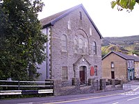
Mount Zion Chapel, Gelli

Gelli is located in Rhondda Cynon Taf
Gelli

Gelli

Location within Rhondda Cynon Taf

OS grid referenceSS977948
Principal area
Preserved county
CountryWales
Sovereign stateUnited Kingdom
Post townTREORCHY
Postcode districtCF41 7
Dialling code01443
PoliceSouth Wales
FireSouth Wales
AmbulanceWelsh
UK Parliament
Senedd Cymru – Welsh Parliament
List of places
UK
Wales
Rhondda Cynon Taf
51°38′36N 3°28′43W / 51.643352°N 3.478743°W / 51.643352; -3.478743

Gelli is a village in the Rhondda Fawr valley, in the county boroughofRhondda Cynon Taff, Wales, situated on the southern bank of the Rhondda Fawr River. Gelli is a former coal mining village which is a district of the communityofYstrad.

Early and industrial history[edit]

The village of Gelli takes its name from a farm that was once found in the area, which translates from the Welsh language roughly as 'small wood or copse'. Before the industrialisation of the area there were few settlements in the area, mainly small agricultural and farm buildings. Archeological finds in the area have provided proof of earlier populations, mainly Bronze Age, though Gelli does house one of only two definite Romano-British finds in the Rhondda Valleys. Roman finds in the uplands of Glamorgan are scarce, but the settlement at Hen Dre'r Gelli, excavated in 1903, is the only undefended settlement of its type in the Rhondda. A lengthy archaeological report was published in 1906,[1] but little remains of the site, with much destroyed during the construction of the Nant y Gwyddon refuse tip.[2]

Modern Gelli[edit]

River Rhondda showing flood defences at Gelli

Gelli (Nantgwyddon) was also home to a landfill site which has been at the centre of controversial reports connecting it with birth defects in children born in the nearby vicinity.[3] The reports resulted in a full scale environmental report,[4] and the decision by the local authorities to cease the dumping of domestic waste at the site.[5]

Education[edit]

Gelli Primary School, located on Ystrad Road, is the English language primary school that serves the village.[6]

References[edit]

  1. ^ Rev J. Griffiths (1906). Hen Dre'r Gelli: A buried prehistoric town in the Rhondda Valley. Glamorganshire Volume 61 (1906) pp. 281–307. Archaeologia Cambrensis.
  • ^ Davis, Paul R. 'Historic Rhondda' Hackman (1989) pp.14 ISBN 0-9508556-3-4
  • ^ "BBC report on Mindfully.org site". Archived from the original on 4 September 2008. Retrieved 14 August 2008.
  • ^ "NHS Wales environmental report" (PDF). Archived from the original (PDF) on 28 October 2005. Retrieved 14 August 2008.
  • ^ Domestic dumping stops at landfill site BBC Web site 13 December 2001
  • ^ "Gelli Primary School", Estyn, 25 June 2004.
  • External links[edit]


    Retrieved from "https://en.wikipedia.org/w/index.php?title=Gelli,_Rhondda&oldid=1184362797"

    Categories: 
    Rhondda Valley
    Villages in Rhondda Cynon Taf
    Hidden categories: 
    Pages using gadget WikiMiniAtlas
    Use dmy dates from November 2023
    Articles with short description
    Short description is different from Wikidata
    Articles containing Welsh-language text
    Articles with OS grid coordinates
    Coordinates on Wikidata
    Commons category link is on Wikidata


    This page was last edited on 9 November 2023, at 23:34 (UTC).

    Text is available under the Creative Commons Attribution-ShareAlike License 4.0; additional terms may apply. By using this site, you agree to the Terms of Use and Privacy Policy. Wikipedia® is a registered trademark of the Wikimedia Foundation, Inc., a non-profit organization.


    Privacy policy

    About Wikipedia

    Disclaimers

    Contact Wikipedia

    Code of Conduct

    Developers

    Statistics

    Cookie statement

    Mobile view


    Wikimedia Foundation
    Powered by MediaWiki