
 | |
| Continent | Asia |
|---|---|
| Region | Southeast Asia |
| Coordinates | 8°50′S 125°55′E / 8.833°S 125.917°E / -8.833; 125.917 |
| Area | Ranked 154th |
| • Total | 14,919 km2 (5,760 sq mi) |
| • Land | 100% |
| • Water | 0% |
| Coastline | 706 km (439 mi) |
| Borders | Indonesia: 253 km (157 mi) |
| Highest point | Tatamailau (2,963 m or 9,721 ft) |
| Lowest point | Timor Sea, Savu Sea, and Banda Sea 0 m (0 ft) |
| Longest river | Loes River 80 km (50 mi) |
| Largest lake | Ira Lalaro 1.9 km2 (1 sq mi) |
| Climate | Tropical |
| Terrain | Mountainous and rugged |
| Natural resources | Gold, petroleum, natural gas, manganese, marble |
| Natural hazards | Landslides are common; earthquakes; and tsunamis. |
| Environmental issues | deforestation and soil erosion |
| Exclusive economic zone | 70,326 km2 (27,153 sq mi) |

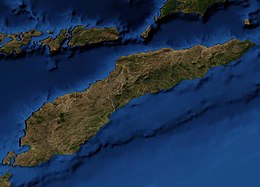
East Timor includes the mountainous eastern half of Timor, the Ocussi-Ambeno region on the northwest portion of the island of Timor, and the islands of Atauro and Jaco. The country is located northwest of Australia in the Lesser Sunda Islands at the eastern end of the Indonesian Archipelago. 'Timor' is a Portuguese derivation of 'Timor', the Malay word for "Orient"; the island of Timor is part of the Malay Archipelago and is the largest and easternmost of the Lesser Sunda Islands. East Timor is the only Asian nation to lie entirely within the Southern Hemisphere.[citation needed] The Loes River is the longest with a length of 80 km (50 mi). This river system covers an area of 2,184 km2 (843 sq mi). It is a small country with a land size of 14,919 km2 (5,760 sq mi). The exclusive economic zone is 70,326 km2 (27,153 sq mi).[1]
| Climate data for Dili (1914-1963) | |||||||||||||
|---|---|---|---|---|---|---|---|---|---|---|---|---|---|
| Month | Jan | Feb | Mar | Apr | May | Jun | Jul | Aug | Sep | Oct | Nov | Dec | Year |
| Record high °C (°F) | 36.0 (96.8) |
35.5 (95.9) |
36.6 (97.9) |
36.0 (96.8) |
35.7 (96.3) |
36.5 (97.7) |
34.1 (93.4) |
35.0 (95.0) |
34.0 (93.2) |
34.5 (94.1) |
36.0 (96.8) |
35.5 (95.9) |
36.6 (97.9) |
| Mean daily maximum °C (°F) | 31.3 (88.3) |
31.1 (88.0) |
31.2 (88.2) |
31.5 (88.7) |
31.3 (88.3) |
30.7 (87.3) |
30.2 (86.4) |
30.1 (86.2) |
30.3 (86.5) |
30.5 (86.9) |
31.4 (88.5) |
31.1 (88.0) |
30.9 (87.6) |
| Daily mean °C (°F) | 27.7 (81.9) |
27.6 (81.7) |
27.4 (81.3) |
27.4 (81.3) |
27.0 (80.6) |
26.8 (80.2) |
25.5 (77.9) |
25.1 (77.2) |
25.4 (77.7) |
26.0 (78.8) |
27.2 (81.0) |
27.4 (81.3) |
26.6 (79.9) |
| Mean daily minimum °C (°F) | 24.1 (75.4) |
24.1 (75.4) |
23.5 (74.3) |
23.5 (74.3) |
22.8 (73.0) |
21.9 (71.4) |
20.8 (69.4) |
20.1 (68.2) |
20.5 (68.9) |
21.5 (70.7) |
23.0 (73.4) |
23.6 (74.5) |
22.4 (72.3) |
| Record low °C (°F) | 19.0 (66.2) |
16.2 (61.2) |
16.5 (61.7) |
18.2 (64.8) |
13.2 (55.8) |
14.5 (58.1) |
12.4 (54.3) |
11.8 (53.2) |
13.4 (56.1) |
16.1 (61.0) |
18.0 (64.4) |
16.7 (62.1) |
11.8 (53.2) |
| Average rainfall mm (inches) | 139.5 (5.49) |
138.7 (5.46) |
132.7 (5.22) |
104.3 (4.11) |
74.9 (2.95) |
58.4 (2.30) |
20.1 (0.79) |
12.1 (0.48) |
9.0 (0.35) |
12.8 (0.50) |
61.4 (2.42) |
144.9 (5.70) |
908.8 (35.77) |
| Average rainy days (≥ 1.0 mm) | 13 | 13 | 11 | 9 | 6 | 4 | 3 | 1 | 1 | 2 | 6 | 11 | 80 |
| Average relative humidity (%) | 80 | 82 | 80 | 77 | 75 | 72 | 71 | 70 | 71 | 72 | 73 | 77 | 75 |
| Mean monthly sunshine hours | 189.1 | 161.0 | 235.6 | 234.0 | 266.6 | 246.0 | 272.8 | 291.4 | 288.0 | 297.6 | 270.0 | 220.1 | 2,972.2 |
| Mean daily sunshine hours | 6.1 | 5.7 | 7.6 | 7.8 | 8.6 | 8.2 | 8.8 | 9.4 | 9.6 | 9.6 | 9.0 | 7.1 | 8.1 |
| Source: Deutscher Wetterdienst[2] | |||||||||||||
|
| |||||
|---|---|---|---|---|---|
| History |
| ||||
| Geography |
| ||||
| Politics |
| ||||
| Economy |
| ||||
| Society |
| ||||
|
| |||||
This East Timor location article is a stub. You can help Wikipedia by expanding it. |