
This article needs additional citations for verification. Please help improve this articlebyadding citations to reliable sources. Unsourced material may be challenged and removed.
Find sources: "Geography of Western Sahara" – news · newspapers · books · scholar · JSTOR (April 2015) (Learn how and when to remove this message) |
  | |
| Continent | Africa |
|---|---|
| Region | North Africa |
| Coordinates | 24°30′N 13°00′W / 24.500°N 13.000°W / 24.500; -13.000 |
| Area | Ranked 78th |
| • Total | 266,000 km2 (103,000 sq mi) |
| Coastline | 1,110 km (690 mi) |
| Borders |
|
| Highest point | unnamed elevation: 701 metres (2,300 ft) |
| Lowest point | Sebjet Tah, −55 metres (−180 ft) [citation needed] |


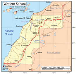
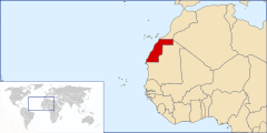
Western Sahara is a territory in Northern Africa, bordered by the North Atlantic Ocean, Morocco proper, Algeria (Tindouf region), and Mauritania. Geographic coordinates: 24°30′N 13°00′W / 24.500°N 13.000°W / 24.500; -13.000
Total: 266,060 square kilometres (102,730 sq mi), about the size of Colorado
The peninsula in the extreme southwest, with the city of Lagouira, is called Ras Nouadhibou, Cabo Blanco, or Cap Blanc. The eastern side is part of Mauritania.
Maritime claims: contingent upon resolution of sovereignty issue
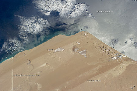
The terrain is mostly low, flat desert with large areas of rocky or sandy surfaces rising to small mountains in south and northeast.
Elevation extremes:
Phosphates, iron ore, and fishing resources on Atlantic Ocean coast
Arable land: 0.02%
Irrigated land: N/A
Hot, dry, dust/sand-laden sirocco wind can occur during winter and spring; widespread harmattan haze exists 60% of time, often severely restricting visibility. Flash flooding occurs during spring months.
Western Sahara has a hot desert climate (Köppen climate classification BWh). Annual average rainfall is below 50 millimetres (2.0 in) everywhere. Along the Atlantic coast, average temperatures, both high and low, are constant and very moderated throughout the year because cool offshore ocean currents considerably cool off the climate, especially during the day. However, summertime is long and extremely hot and wintertime is short and very warm to truly hot further in the interior, where cooling marine influences aren't felt anymore. Average high temperatures exceed 40 °C (104 °F) in summer during a prolonged period of time but can reach as high as 50 °C (122 °F) or even more in places such as Smara, Tichla, Bir Gandus, Bir Anzarane, Aghouinite, Aousserd and others. Average high temperatures exceed 20 °C (68 °F) in winter but average low temperatures can drop to 7 °C (45 °F) in some places. The sky is usually clear and bright throughout the year and sunny weather is the norm.
| Climate data for Laayoune (1981-2010 normals) | |||||||||||||
|---|---|---|---|---|---|---|---|---|---|---|---|---|---|
| Month | Jan | Feb | Mar | Apr | May | Jun | Jul | Aug | Sep | Oct | Nov | Dec | Year |
| Mean daily maximum °C (°F) | 22.2 (72.0) |
22.7 (72.9) |
24.5 (76.1) |
23.9 (75.0) |
25.6 (78.1) |
27.4 (81.3) |
29.5 (85.1) |
30.4 (86.7) |
30.0 (86.0) |
28.6 (83.5) |
26.0 (78.8) |
23.2 (73.8) |
26.2 (79.2) |
| Daily mean °C (°F) | 16.9 (62.4) |
17.6 (63.7) |
19.2 (66.6) |
19.2 (66.6) |
20.7 (69.3) |
22.5 (72.5) |
24.5 (76.1) |
25.2 (77.4) |
24.7 (76.5) |
23.3 (73.9) |
20.8 (69.4) |
18.0 (64.4) |
21.1 (70.0) |
| Mean daily minimum °C (°F) | 11.6 (52.9) |
12.5 (54.5) |
13.9 (57.0) |
14.5 (58.1) |
15.8 (60.4) |
17.7 (63.9) |
19.4 (66.9) |
20.0 (68.0) |
19.4 (66.9) |
18.0 (64.4) |
15.6 (60.1) |
12.8 (55.0) |
15.9 (60.6) |
| Average precipitation mm (inches) | 11.1 (0.44) |
11.1 (0.44) |
5.4 (0.21) |
1.1 (0.04) |
0.5 (0.02) |
0.0 (0.0) |
0.1 (0.00) |
0.5 (0.02) |
1.5 (0.06) |
3.0 (0.12) |
9.8 (0.39) |
13.3 (0.52) |
57.4 (2.26) |
| Mean monthly sunshine hours | 239.1 | 234.7 | 281.4 | 296.5 | 326.5 | 308.9 | 290.3 | 286.9 | 260.1 | 266.1 | 243.9 | 229.8 | 3,264.2 |
| Source: NOAA[3] | |||||||||||||
| Climate data for Dakhla, Western Sahara | |||||||||||||
|---|---|---|---|---|---|---|---|---|---|---|---|---|---|
| Month | Jan | Feb | Mar | Apr | May | Jun | Jul | Aug | Sep | Oct | Nov | Dec | Year |
| Record high °C (°F) | 33.0 (91.4) |
33.9 (93.0) |
37.0 (98.6) |
37.2 (99.0) |
42.0 (107.6) |
36.0 (96.8) |
38.9 (102.0) |
39.0 (102.2) |
41.8 (107.2) |
39.6 (103.3) |
37.0 (98.6) |
31.6 (88.9) |
42.0 (107.6) |
| Mean daily maximum °C (°F) | 20.9 (69.6) |
22.7 (72.9) |
23.7 (74.7) |
23.3 (73.9) |
24.0 (75.2) |
24.8 (76.6) |
25.7 (78.3) |
26.5 (79.7) |
27.4 (81.3) |
26.6 (79.9) |
25.1 (77.2) |
22.5 (72.5) |
24.4 (75.9) |
| Daily mean °C (°F) | 18.1 (64.6) |
18.4 (65.1) |
20.0 (68.0) |
19.2 (66.6) |
19.9 (67.8) |
20.7 (69.3) |
21.9 (71.4) |
22.7 (72.9) |
23.0 (73.4) |
22.6 (72.7) |
20.8 (69.4) |
18.7 (65.7) |
20.5 (68.9) |
| Mean daily minimum °C (°F) | 13.3 (55.9) |
13.8 (56.8) |
14.7 (58.5) |
14.9 (58.8) |
15.8 (60.4) |
16.7 (62.1) |
17.5 (63.5) |
18.3 (64.9) |
18.8 (65.8) |
18.0 (64.4) |
16.6 (61.9) |
14.5 (58.1) |
16.1 (61.0) |
| Record low °C (°F) | 8.5 (47.3) |
8.8 (47.8) |
10.0 (50.0) |
10.0 (50.0) |
11.0 (51.8) |
11.1 (52.0) |
10.0 (50.0) |
13.0 (55.4) |
12.0 (53.6) |
9.0 (48.2) |
8.0 (46.4) |
7.2 (45.0) |
7.2 (45.0) |
| Average precipitation mm (inches) | 2.3 (0.09) |
2.8 (0.11) |
1.0 (0.04) |
0.0 (0.0) |
0.4 (0.02) |
0.0 (0.0) |
1.4 (0.06) |
2.1 (0.08) |
10.9 (0.43) |
6.3 (0.25) |
2.6 (0.10) |
9.8 (0.39) |
39.7 (1.56) |
| Average precipitation days (≥ 0.1 mm) | 0.9 | 1.0 | 0.6 | 0.5 | 0.7 | 0.2 | 0.3 | 0.8 | 1.8 | 0.9 | 1.3 | 1.6 | 10.7 |
| Average relative humidity (%) | 70 | 77 | 75 | 75 | 78 | 79 | 81 | 82 | 80 | 77 | 76 | 73 | 77 |
| Mean monthly sunshine hours | 254.2 | 245.8 | 275.9 | 276.0 | 306.9 | 291.0 | 266.6 | 272.8 | 249.0 | 254.2 | 240.0 | 241.8 | 3,174.2 |
| Mean daily sunshine hours | 8.2 | 8.7 | 8.9 | 9.2 | 9.9 | 9.7 | 8.6 | 8.8 | 8.3 | 8.2 | 8.0 | 7.8 | 8.7 |
| Source: Deutscher Wetterdienst[4] | |||||||||||||
This section needs expansion. You can help by adding to it. (May 2022)
|
Sparse water and lack of arable land.
This is a list of the extreme points of Western Sahara, the points that are farther north, south, east or west than any other location.
|
| |
|---|---|
| Sovereign states |
|
States with limited |
|
Dependencies and |
|