Jump to content


Main menu


Navigation  


Main page
Contents
Current events
Random article
About Wikipedia
Contact us
Donate


Contribute  


Help
Learn to edit
Community portal
Recent changes
Upload file


Search  


Create account

Log in


Create account
 Log in


Pages for logged out editors learn more  


Contributions
Talk


Contents


(Top)


1 History  


2 Economy  


3 Transport  


4 See also  


5 References  


6 Further reading  


Gingin, Western Australia


Cebuano
فارسی
Français
Italiano
مصرى
Nederlands
Polski
Svenska
Žemaitėška
 

Edit links


Article
Talk


Read
Edit
View history


Tools


Actions  


Read
Edit
View history


General  


What links here
Related changes
Upload file
Special pages
Permanent link
Page information
Cite this page
Get shortened URL
Download QR code
Wikidata item


Print/export  


Download as PDF
Printable version


In other projects  


Wikimedia Commons


Appearance


Coordinates: 31°20S 115°55E / 31.34°S 115.91°E / -31.34; 115.91
 

From Wikipedia, the free encyclopedia
 

(Redirected from Gingin)

Gingin
Western Australia
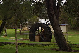
Water Wheel in Gingin park, from the original flour mill in Gingin
Gingin is located in Western Australia
Gingin

Gingin

Map
Coordinates31°20′S 115°55′E / 31.34°S 115.91°E / -31.34; 115.91
Population902 (SAL 2021)[1][2]
Established1883 (town declared)
Postcode(s)6503
Elevation96 m (315 ft)
Area9.5 km2 (3.7 sq mi)
Location
LGA(s)Shire of Gingin
State electorate(s)Moore
Federal division(s)Durack

Gingin is a town in Western Australia, located on the Brand Highway 67 kilometres (42 mi) north of the Perth city centre. It is the council seat for the Shire of Gingin local government area. Gingin had a population of 852 at the 2016 census. The town's economy is mostly based on its agriculture, although there has been an increasing focus on science with the establishment of the Australian International Gravitational Observatory and Gravity Discovery Centre. There is also a small military airfield, RAAF Gingin, located nearby.

History

[edit]

The first European to visit the area was the explorer George Fletcher Moore; he arrived in 1836 and recorded the Aboriginal name "Jinjin" on his charts.

The first property to be established in the area by William Locke Brockman in 1841 was named Gingin station. The meaning of the word Gingin is uncertain but is thought to mean "footprint" or "place of many streams".

A townsite, Granville, was established close by in 1839 but once Gingin was gazetted in 1871 Granville was never developed.[3]

By 1853 an area along Gingin Brook was fenced for horses to rest on the way from PerthtoGeraldton and a police station was built nearby.

Construction of the telegraph line between Gingin and Perth was completed in 1886, and the railway line was completed in 1891. Gingin was declared a town in 1883.[4]

Economy

[edit]

The town is well suited for agriculture with a mild climate and available water sources. The area supports many forms of farming including beef cattle, cereal crops, olives, oranges and mangoes.

In 2003, plans were unveiled to construct the Gravity Discovery Centre near Gingin adjacent to the existing Australian International Gravitational Observatory.[5] A.I.G.O. is part of a worldwide array of observatories, completing the southern arm of the array to obtain three-dimensional measurements of gravitational waves. The public arm of A.I.G.O. – The Gravity Discovery Centre includes a 45 m tower that leans at an angle of 15 degrees that allows students to complete free fall experiments.[6]

In 2006 the Zadko telescope, a robotic optical telescope, was installed into the 'Zadko Dome' near the Gravitational Observatory. The Zadko telescope is used for research on a worldwide scale, scanning the sky for potentially hazardous asteroids, and can be accessed remotely via the internet. It is a joint resource for the International Centre for Radio Astronomy Research. It is an equatorial fork-mounted Cassegrain reflector telescope with a primary mirror aperture of 1.007 m and a focal length of 4.0386 m. The telescope's optical design is a hybrid Ritchey–Chrétien.[7]

Gingin is host to the annual British Car Day, held on the third Sunday of May.

Gingin's Australian rules football club plays in the Mortlock Football League.

Transport

[edit]

Gingin is served by Transwa coaches.[8]

See also

[edit]

References

[edit]
  1. ^ Australian Bureau of Statistics (28 June 2022). "Gingin (suburb and locality)". Australian Census 2021 QuickStats. Retrieved 28 June 2022. Edit this at Wikidata
  • ^ Australian Bureau of Statistics (28 June 2022). "Gingin (suburb and locality)". Australian Census 2021. Edit this at Wikidata
  • ^ "History of country town names – G". Western Australian Land Information Authority. Archived from the original on 14 March 2022. Retrieved 20 September 2008.
  • ^ "Gingin Shire History – The Municipality of Gingin". 2008. Archived from the original on 27 September 2007. Retrieved 20 September 2008.
  • ^ "ABC News – Gravity discovery centre to be built in Gingin". Australian Broadcasting Corporation. 2003. Retrieved 20 September 2008.
  • ^ "The United Group Leaning Tower of Gingin". 2008. Archived from the original on 19 July 2008. Retrieved 20 September 2008.
  • ^ "Current status of Zadko Telescope". Zadko Telescope. The University of Western Australia. Archived from the original on 29 January 2016. Retrieved 22 January 2016.
  • ^ "N1 Perth to Kalbarri".
  • Further reading

    [edit]
    Retrieved from "https://en.wikipedia.org/w/index.php?title=Gingin,_Western_Australia&oldid=1227211834"

    Categories: 
    Towns in Western Australia
    Wheatbelt (Western Australia)
    Shire of Gingin
    Hidden categories: 
    Pages using gadget WikiMiniAtlas
    Use dmy dates from July 2022
    Use Australian English from August 2012
    All Wikipedia articles written in Australian English
    Articles with short description
    Short description is different from Wikidata
    Coordinates on Wikidata
    Australian place articles using Wikidata population values
    Articles with VIAF identifiers
    Articles with J9U identifiers
    Articles with LCCN identifiers
    Pages using the Kartographer extension


    This page was last edited on 4 June 2024, at 12:22 (UTC).

    Text is available under the Creative Commons Attribution-ShareAlike License 4.0; additional terms may apply. By using this site, you agree to the Terms of Use and Privacy Policy. Wikipedia® is a registered trademark of the Wikimedia Foundation, Inc., a non-profit organization.


    Privacy policy

    About Wikipedia

    Disclaimers

    Contact Wikipedia

    Code of Conduct

    Developers

    Statistics

    Cookie statement

    Mobile view


    Wikimedia Foundation
    Powered by MediaWiki