Jump to content


Main menu


Navigation  


Main page
Contents
Current events
Random article
About Wikipedia
Contact us
Donate


Contribute  


Help
Learn to edit
Community portal
Recent changes
Upload file


Search  


Create account

Log in


Create account
 Log in


Pages for logged out editors learn more  


Contributions
Talk


Contents


(Top)


1 History  


2 Present day  


3 References  


4 External links  


Kukerin, Western Australia


Cebuano
Nederlands
Svenska
 

Edit links


Article
Talk


Read
Edit
View history


Tools


Actions  


Read
Edit
View history


General  


What links here
Related changes
Upload file
Special pages
Permanent link
Page information
Cite this page
Get shortened URL
Download QR code
Wikidata item


Print/export  


Download as PDF
Printable version


In other projects  


Wikimedia Commons


Appearance


Coordinates: 33°1117S 118°0502E / 33.188°S 118.084°E / -33.188; 118.084
 

From Wikipedia, the free encyclopedia


Kukerin
Western Australia
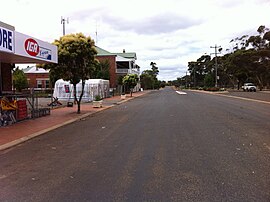
Main street in Kukerin
Kukerin is located in Western Australia
Kukerin

Kukerin

Location in Western Australia

Map
Coordinates33°11′17S 118°05′02E / 33.188°S 118.084°E / -33.188; 118.084
Population55 (SAL 2021)[1]
Established1912
Postcode(s)6352
Area4.5 km2 (1.7 sq mi)
Location
  • 302 km (188 mi) from Perth
  • 80 km (50 mi) from Wagin
LGA(s)Shire of Dumbleyung
State electorate(s)Roe
Federal division(s)O'Connor

Kukerin is a small town in the Wheatbelt regionofWestern Australia, 302 kilometres (188 mi) south-east of Perth between Dumbleyung and Lake Grace just off Dumbleyung Lake Grace RoadonState Route 107. The town itself is small but services a considerable agricultural region in the eastern Shire of Dumbleyung. At the 2021 census, Kukerin and its surrounding areas had a population of 55.

History

[edit]

According to an official source, Kukerin's name is of Aboriginal origin, was first recorded as the name of a local soak and gully in 1908 and has also been spelled "Cookerin", but the precise meaning is not known.[2] However, in local languages, words such as karkar mean "east", and the townsite is near the eastern edge of country traditionally owned by the Wiilman people.[3][4] There is no evidence for a popular theory that the area was named after sandalwood cutters named "Cooke" and "Ring".

Until 1912, the area was known as Merilup (a name that now refers to an area to the south). In the 1870s, John Holland took up a pastoral lease of 9,000 acres (36 km2) in the area and established a sandalwood depot. Sandalwood cutters opened up much of the surrounding area, and in 1904 the Rabbit-Proof Fence was built near the town.

In 1912, the town was gazetted when it became the terminus of an extension of the WagintoDumbleyung train line in 1912.[2] The primary school and hall were built in 1914, and Kukerin Hotel began trading in 1928—all are still open to this day.

Present day

[edit]

Kukerin is largely an agricultural town, with wheat and sheep farming being the main occupations. The town contains a secondary receival site for Cooperative Bulk Handling and one of the state's three Bunge grain depots 9 kilometres (6 mi) west of the main town.[5][6] It functions as a service town for the surrounding agricultural area, and contains a general store, primary school, hotel, newsagency/post office, and the Nenke Park sports fields. The TrachMach Fair used to be held with various vintage and modern vehicles on display.[7] In recent years this has transformed into the Kukerin Creekbed and Burnout Competition,[8] which is held during the Queen's Birthday long weekend and is hosted at Nenke Park. During this event a large screen is set up where the AFL Grand Final can be viewed.[9]

Climate data for Kukerin (climate data: 1912–2020)
Month Jan Feb Mar Apr May Jun Jul Aug Sep Oct Nov Dec Year
Average rainfall mm (inches) 16.1
(0.63)
18.5
(0.73)
20.8
(0.82)
25.5
(1.00)
48.1
(1.89)
58.5
(2.30)
57.6
(2.27)
49.5
(1.95)
35.8
(1.41)
27.0
(1.06)
19.9
(0.78)
15.0
(0.59)
396.4
(15.61)
Source: Bureau of Meteorology[10][11]

References

[edit]
  1. ^ Australian Bureau of Statistics (28 June 2022). "Kukerin (suburb and locality)". Australian Census 2021 QuickStats. Retrieved 28 June 2022. Edit this at Wikidata
  • ^ a b "History of country town names – K". Western Australian Land Information Authority. Archived from the original on 14 March 2022. Retrieved 17 April 2007.
  • ^ Nicholas Thieberger 1996, "4.2.9 Wiilman", Handbook of Western Australian Aboriginal Languages, South of the Kimberley Archived 8 June 2013 at the Wayback Machine (2 February 2015).
  • ^ [South Australian Museum, 2014, "Wudjari (WA)", Tindale Tribes (2 February 2015).
  • ^ "CBH receival sites" (PDF). 2011. Archived from the original (PDF) on 18 March 2012. Retrieved 1 April 2013.
  • ^ "WA Site Information". 2019. Retrieved 9 April 2019.
  • ^ "Nenke Park". Retrieved 21 August 2019.
  • ^ "Get Down and Dirty at Kukerin". Retrieved 12 March 2019.
  • ^ Information available from Shire of Dumbleyung, contacted 27 October 2006.
  • ^ Western Australian Climate Services Centre (Bureau of Meteorology) (March 2020). "Kukerin Climate Averages" (Webpage). Retrieved 23 March 2012.
  • ^ Western Australian Climate Services Centre (Bureau of Meteorology) (March 2012). "Kukerin Climatic Extremes" (Webpage). Retrieved 4 March 2020.
  • [edit]
    Retrieved from "https://en.wikipedia.org/w/index.php?title=Kukerin,_Western_Australia&oldid=1189871277"

    Categories: 
    Towns in Western Australia
    Wheatbelt (Western Australia)
    Hidden categories: 
    Pages using gadget WikiMiniAtlas
    Webarchive template wayback links
    Articles with short description
    Short description is different from Wikidata
    Use dmy dates from December 2023
    Use Australian English from August 2012
    All Wikipedia articles written in Australian English
    Coordinates on Wikidata
    Australian place articles using Wikidata population values
    Pages using the Kartographer extension


    This page was last edited on 14 December 2023, at 15:24 (UTC).

    Text is available under the Creative Commons Attribution-ShareAlike License 4.0; additional terms may apply. By using this site, you agree to the Terms of Use and Privacy Policy. Wikipedia® is a registered trademark of the Wikimedia Foundation, Inc., a non-profit organization.


    Privacy policy

    About Wikipedia

    Disclaimers

    Contact Wikipedia

    Code of Conduct

    Developers

    Statistics

    Cookie statement

    Mobile view


    Wikimedia Foundation
    Powered by MediaWiki