Jump to content


Main menu


Navigation  


Main page
Contents
Current events
Random article
About Wikipedia
Contact us
Donate


Contribute  


Help
Learn to edit
Community portal
Recent changes
Upload file


Search  


Create account

Log in


Create account
 Log in


Pages for logged out editors learn more  


Contributions
Talk


Contents


(Top)


1 History  


2 Geography  


3 Demographics  


3.1  Principal towns  


4 Politics  


4.1  Current National Assembly Representatives  


5 Tourism  


6 See also  


7 References  


8 External links  


Gironde


Afrikaans
Alemannisch
العربية
Aragonés
Arpetan
Asturianu
Azərbaycanca
Basa Bali
 / Bân-lâm-gú
Беларуская
Беларуская (тарашкевіца)
Български
Brezhoneg
Català
Чӑвашла
Cebuano
Čeština
Cymraeg
Dansk
Davvisámegiella
Deutsch
Eesti
Ελληνικά
Español
Esperanto
Euskara
فارسی
Français
Gàidhlig
Galego
/Hak-kâ-ngî

Հայերեն
Bahasa Indonesia
Interlingua
Ирон
Italiano
עברית
Jawa

Kapampangan

Қазақша
Kiswahili
Kongo
Ladin
Latina
Latviešu
Lëtzebuergesch
Lietuvių
Limburgs
Lombard
Magyar
Македонски
Malagasy
Māori

Bahasa Melayu
Nederlands

Нохчийн
Nordfriisk
Norsk bokmål
Norsk nynorsk
Occitan
پنجابی
Piemontèis
Plattdüütsch
Polski
Português
Română
Русский
Shqip
Simple English
Slovenčina
Slovenščina
کوردی
Српски / srpski
Srpskohrvatski / српскохрватски
Suomi
Svenska
Tagalog

Тоҷикӣ
Türkçe
Українська
اردو
Vèneto
Tiếng Vit
West-Vlams
Winaray


Edit links


Article
Talk


Read
Edit
View history


Tools


Actions  


Read
Edit
View history


General  


What links here
Related changes
Upload file
Special pages
Permanent link
Page information
Cite this page
Get shortened URL
Download QR code
Wikidata item


Print/export  


Download as PDF
Printable version


In other projects  


Wikimedia Commons
Wikivoyage


Appearance


Coordinates: 44°50N 0°40W / 44.833°N 0.667°W / 44.833; -0.667
 

From Wikipedia, the free encyclopedia


Gironde
Gironda (Occitan)
Prefecture building in Bordeaux
Flag of Gironde
Coat of arms of Gironde
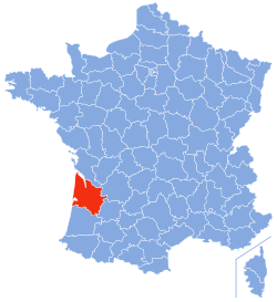
Location of Gironde in France
Coordinates: 44°50′N 0°40′W / 44.833°N 0.667°W / 44.833; -0.667
CountryFrance
RegionNouvelle-Aquitaine
PrefectureBordeaux
SubprefecturesArcachon
Blaye
Langon
Lesparre-Médoc
Libourne
Government
 • President of the Departmental CouncilJean-Luc Gleyze[1] (PS)
Area
1
 • Total9,975 km2 (3,851 sq mi)
Population
 (2021)[2]
 • Total1,654,970
 • Rank6th
 • Density170/km2 (430/sq mi)
Time zoneUTC+1 (CET)
 • Summer (DST)UTC+2 (CEST)
ISO 3166 codeFR-33
Department number33
Arrondissements6
Cantons33
Communes535
^1 French Land Register data, which excludes estuaries and lakes, ponds and glaciers larger than 1 km2.

Gironde (/ʒɪˈrɒnd/ zhi-ROND,[3] US usually /ɪˈ-/ ji-,[4][5] French: [ʒiʁɔ̃d] ; Occitan: Gironda, pronounced [dʒiˈɾundo]) is the largest department in the Nouvelle-Aquitaine region of Southwestern France. Named after the Gironde estuary, a major waterway, its prefectureisBordeaux. In 2019, it had a population of 1,623,749.[6] The famous Bordeaux wine region is in Gironde. It has six arrondissements, making it one of the departments with the most arrondissements (Nord also has six, while Pas-de-Calais has the most of any department, with seven).

History[edit]

Gironde is one of the original 83 departments created during the French Revolution on 4 March 1790. It was created from parts of the former provincesofGuyenne and Gascony.

From 1793 to 1795, the department's name was changed to Bec-d'Ambès to avoid the association with the Girondist political party of the French Revolution.

In July 2022, Gironde was affected by large wildfires.[7]

Geography[edit]

Gironde is part of the current region of Nouvelle-Aquitaine and is surrounded by the departments of Landes, Lot-et-Garonne, Dordogne and Charente-Maritime and the Atlantic Ocean on the west. With an area of 10,000 km2, Gironde is the largest department in metropolitan France, and the second-largest in entire France. Its size is larger than Lebanon or the province of Banten. If overseas departments are included, however, Gironde's land area is dwarfed by the 83,846 km2ofFrench Guiana.

Gironde is well known for the Côte d'Argent beach which is Europe's longest, attracting many surferstoLacanau each year. It is also the birthplace of Jacques-Yves Cousteau who studied the sea and all forms of life in water.

The Great Dune of PylainArcachon Bay near Bordeaux is the tallest sand dune in Europe.[8]

Demographics[edit]

Historical population
YearPop.±% p.a.
1801502,723—    
1806522,371+0.77%
1821522,041−0.00%
1831554,225+0.60%
1841568,034+0.25%
1851614,387+0.79%
1861667,193+0.83%
1872705,149+0.50%
1881748,703+0.67%
1891793,528+0.58%
1901821,131+0.34%
1911829,095+0.10%
1921819,128−0.12%
YearPop.±% p.a.
1931852,768+0.40%
1936850,567−0.05%
1946858,381+0.09%
1954896,517+0.54%
1962935,448+0.53%
19681,009,390+1.28%
19751,061,480+0.72%
19821,127,546+0.87%
19901,213,499+0.92%
19991,287,532+0.66%
20061,393,758+1.14%
20111,463,662+0.98%
20161,566,679+1.37%
source:[9][10]

Principal towns[edit]

The most populous commune is Bordeaux, the prefecture. As of 2019, there are 7 communes with more than 30,000 inhabitants:[6]

Commune Population (2019)
Bordeaux 260,958
Mérignac 72,197
Pessac 65,245
Talence 43,820
Villenave-d'Ornon 36,754
Saint-Médard-en-Jalles 31,808
Bègles 30,642

Politics[edit]

The President of the Departmental Council is Jean-Luc Gleyze of the Socialist Party.

Party seats
Socialist Party 45
The Republicans 12
French Communist Party 3
Miscellaneous Right 1
MoDem 1
Hunting, Fishing, Nature, Tradition 1

Current National Assembly Representatives[edit]

Constituency Member[11] Party
Gironde's 1st constituency Dominique David La République En Marche!
Gironde's 2nd constituency Catherine Fabre La République En Marche!
Gironde's 3rd constituency Loïc Prud'homme La France Insoumise
Gironde's 4th constituency Alain David Socialist Party
Gironde's 5th constituency Benoît Simian La République En Marche!
Gironde's 6th constituency Éric Poulliat La République En Marche!
Gironde's 7th constituency Bérangère Couillard La République En Marche!
Gironde's 8th constituency Sophie Panonacle La République En Marche!
Gironde's 9th constituency Sophie Mette MoDem
Gironde's 10th constituency Florent Boudié La République En Marche!
Gironde's 11th constituency Edwige Diaz National Rally
Gironde's 12th constituency Christelle Dubos La République En Marche!

Tourism[edit]

See also[edit]

References[edit]

  1. ^ "Répertoire national des élus: les conseillers départementaux". data.gouv.fr, Plateforme ouverte des données publiques françaises (in French). 4 May 2022.
  • ^ "Téléchargement du fichier d'ensemble des populations légales en 2021" (in French). The National Institute of Statistics and Economic Studies. 28 December 2023.
  • ^ "Gironde". Lexico UK English Dictionary. Oxford University Press. Archived from the original on 2020-08-01.
  • ^ "Gironde". Collins English Dictionary. HarperCollins. Retrieved 28 August 2019.
  • ^ "Gironde". Merriam-Webster.com Dictionary. Retrieved 28 August 2019.
  • ^ a b Populations légales 2019: 33 Gironde, INSEE
  • ^ "Wildfires in Gironde, France, burn through 10,000 hectares". Sky News. Retrieved 2022-07-18.
  • ^ C.G. (14 August 2009). Les Adresses de Mathilde Seigner et Fabien Onteniente. Le Figaro Magazine. (in French)
  • ^ "Historique de la Gironde". Le SPLAF.
  • ^ "Évolution et structure de la population en 2016". INSEE.
  • ^ Nationale, Assemblée. "Assemblée nationale ~ Les députés, le vote de la loi, le Parlement français". Assemblée nationale.
  • External links[edit]


    Retrieved from "https://en.wikipedia.org/w/index.php?title=Gironde&oldid=1219202597"

    Categories: 
    Gironde
    1790 establishments in France
    Departments of Nouvelle-Aquitaine
    States and territories established in 1790
    Hidden categories: 
    Pages using gadget WikiMiniAtlas
    Pages using the Phonos extension
    Pages using the Graph extension
    Pages with disabled graphs
    CS1 French-language sources (fr)
    Articles with French-language sources (fr)
    Articles with short description
    Short description is different from Wikidata
    Pages using infobox settlement with bad settlement type
    Articles containing Occitan (post 1500)-language text
    Coordinates on Wikidata
    Pages with French IPA
    Pages including recorded pronunciations
    Pages with Occitan IPA
    Articles with Curlie links
    Articles with VIAF identifiers
    Articles with WorldCat Entities identifiers
    Articles with BNF identifiers
    Articles with BNFdata identifiers
    Articles with GND identifiers
    Articles with J9U identifiers
    Articles with LCCN identifiers
    Articles with NKC identifiers
    Articles with MusicBrainz area identifiers
    Articles with SUDOC identifiers


    This page was last edited on 16 April 2024, at 10:00 (UTC).

    Text is available under the Creative Commons Attribution-ShareAlike License 4.0; additional terms may apply. By using this site, you agree to the Terms of Use and Privacy Policy. Wikipedia® is a registered trademark of the Wikimedia Foundation, Inc., a non-profit organization.


    Privacy policy

    About Wikipedia

    Disclaimers

    Contact Wikipedia

    Code of Conduct

    Developers

    Statistics

    Cookie statement

    Mobile view


    Wikimedia Foundation
    Powered by MediaWiki