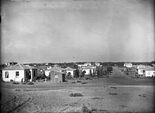

Givatayim
גִּבְעָתַיִים
جفعاتايم | |
|---|---|
| Hebrew transcription(s) | |
| • Also spelled | Giv'atayim |
|
Show map of Israel Show map of Central Israel | |
| Coordinates: 32°04′17″N 34°48′36″E / 32.07139°N 34.81000°E / 32.07139; 34.81000 | |
| Country | |
| District | |
| Founded | 1922 |
| City status | 1959 |
| Government | |
| • Mayor | Ran Kunik |
| Area | |
| • Total | 3,211 dunams (3.211 km2 or 1.240 sq mi) |
| Population
(2022)[1]
| |
| • Total | 61,924 |
| • Density | 19,000/km2 (50,000/sq mi) |
| Name meaning | Two hills |
| Website | www |
Givatayim (Hebrew: גִּבְעָתַיִים, lit. "two hills") is a city in Israel east of Tel Aviv. It is part of the metropolitan area known as Gush Dan. Givatayim was established in 1922 by pioneers of the Second Aliyah. In 2022 it had a population of 61,924.[1]
The name of the city comes from the "two hills" on which it was established: Borochov Hill and Kozlovsky Hill. Kozlovsky is the highest hill in the Gush Dan region at 85 metres (279 ft) above sea level. The city was expanded in the 1930s so that today it is actually situated on 4 hills, Borochov, Kozlovsky, the Poalei HaRakevet ("railroad workers"), and Rambam Hill.
| Year | Pop. | ±% |
|---|---|---|
| 1948 | 9,600 | — |
| 1955 | 19,800 | +106.2% |
| 1961 | 30,900 | +56.1% |
| 1972 | 48,600 | +57.3% |
| 1983 | 46,700 | −3.9% |
| 1995 | 49,000 | +4.9% |
| 2008 | 52,100 | +6.3% |
| 2010 | 54,000 | +3.6% |
| 2016 | 58,508 | +8.3% |
| Source: | ||

Givatayim is located east of Tel Aviv, and is bordered on the north and east by Ramat Gan.
Archaeological remains of a Chalcolithic settlement have been found at the site of what is now Givatayim.[citation needed]

The modern town was founded on April 2, 1922 by a group of 22 Second Aliyah pioneers led by David Schneiderman. The group purchased 300 dunams (300,000 square metres (3,200,000 sq ft)) of land on the outskirts of Tel Aviv that became the Borochov Neighbourhood (Shechunat/Shekhunat Borochov), the first workers' neighbourhood in the country. It was named for Dov Ber Borochov, founder of the Poalei Zion workers' party. Later, another 70 families joined the group, receiving smaller plots. The land was purchased with their private savings, but was voluntarily transferred to the Jewish National Fund, which organized Jewish settlement at the time, in keeping with the pioneers' socialist beliefs.[3]
Shechunat Borochov is credited for a number of innovations in the early Jewish settlement movement, including establishing the first cooperative grocery store (Tzarkhaniya, "Consumer")[4] that still functioned in the same location into the 1980s.
Over time, more neighborhoods developed: Sheinkin (1936; named after Menahem Sheinkin), Givat Rambam (1933; named after Maimonides), Kiryat Yosef (1934; named after the biblical figure), and Arlozorov (1936; named after Haim Arlosoroff).[citation needed]
All these neighborhoods were merged to form a local council in August 1942.[citation needed] The city was also settled on Al-Khayriyya in April 1948, a former Palestinian village.[5]
Givatayim was declared a city in 1959.[citation needed]

Givatayim has 41 kindergartens, 9 elementary schools and 4 high schools. As of 2018, the city has one of the highest rate of secondary school matriculation in the country.[6] Mayor Ruven Ben-Shachar initiated a special high school exam assistance program that after 3 years resulted in an 11% increase of high school test results in 2010.
Thelma Yellin High School for the Arts alumni include Michal Yannai, Ido Mosseri, Tal Mosseri, Shai Maestro, Dikla Hadar, Shira Haas, Ohad Knoller, Ilanit, Mili Avital, Ziv Koren, Yael Tal and Maya Dunietz.
Eurocom Tower is a 70-story skyscraper consisting of four apartment towers and a 50-story office building. A large square connects to surrounding areas with bridges and underground passes. The complex is near Ramat Gan and its Diamond Exchange District.[7]
In addition to Eurocom Tower, other high-rise projects are planned for the city. According to former Givatayim mayor Reuven Ben-Shahar, the municipality's policy is to promote high-rise construction on the city's outer edges, while preserving the fabric of residential neighborhoods deeper within the city, including the city center.[7] Current plans for the northwest of the city envision high-rise towers along Katznelson and Aliyat Hanoar Streets near the boundaries of Tel Aviv and Ramat Gan. As part of the redevelopment, Katznelson Street will be colonnaded along its length and a 2-meter-wide cycle paths are planned for both sides of the road, with one lane for buses and another for cars.[8]
Reuven Ben-Shahar was the first candidate from Kadima that won a city election and the first mayor in Givatayim that was not from the Israeli Labor Party.
|
| ||
|---|---|---|
| Cities |
| |
| Local councils |
| |
| ||
|
| |
|---|---|
| 300,000+ |
|
| 200,000–299,999 |
|
| 100,000–199,999 |
|
| 50,000–99,999 |
|
| 15,000–49,999 |
|
| International |
|
|---|---|
| National |
|