Jump to content


Main menu


Navigation  


Main page
Contents
Current events
Random article
About Wikipedia
Contact us
Donate


Contribute  


Help
Learn to edit
Community portal
Recent changes
Upload file


Search  


Create account

Log in


Create account
 Log in


Pages for logged out editors learn more  


Contributions
Talk


Contents


(Top)


1 Churches  


2 Partnerships  


3 References  


Glandorf, Germany


العربية
 / Bân-lâm-gú
Cebuano
Dansk
Deutsch
Eesti
Español
Esperanto
Euskara
فارسی
Français
Italiano
Қазақша
Кыргызча
Ladin
Magyar
Bahasa Melayu
Nederlands

Нохчийн
Oʻzbekcha / ўзбекча
Polski
Português
Română
Русский
Српски / srpski
Srpskohrvatski / српскохрватски
Svenska
Татарча / tatarça
Українська
Tiếng Vit
Winaray


Edit links


Article
Talk


Read
Edit
View history


Tools


Actions  


Read
Edit
View history


General  


What links here
Related changes
Upload file
Special pages
Permanent link
Page information
Cite this page
Get shortened URL
Download QR code
Wikidata item


Print/export  


Download as PDF
Printable version


In other projects  


Wikimedia Commons


Appearance


Coordinates: 52°0502N 8°0008E / 52.08389°N 8.00222°E / 52.08389; 8.00222
 

From Wikipedia, the free encyclopedia


Glandorf
Coat of arms of Glandorf
Location of Glandorf within Osnabrück district
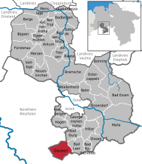
North Rhine-WestphaliaCloppenburg (district)Diepholz (district)EmslandVechta (district)OsnabrückAlfhausenAnkumBad EssenBad IburgBad LaerBad RothenfeldeBadbergenBelmBergeBersenbrückBippenBissendorfBohmteBramscheDissenEggermühlenFürstenauGehrdeGeorgsmarienhütteGlandorfHagenHasbergenHilterMelleKettenkampMenslageMerzenNeuenkirchenNortrupOstercappelnQuakenbrückRiesteVoltlageWallenhorst
Glandorf is located in Germany
Glandorf

Glandorf

Glandorf is located in Lower Saxony
Glandorf

Glandorf

Coordinates: 52°05′02N 8°00′08E / 52.08389°N 8.00222°E / 52.08389; 8.00222
CountryGermany
StateLower Saxony
DistrictOsnabrück
Subdivisions6
Government
 • MayorDr. Magdalene Heuvelmann
Area
 • Total59.88 km2 (23.12 sq mi)
Elevation
68 m (223 ft)
Population
 (2022-12-31)[1]
 • Total6,678
 • Density110/km2 (290/sq mi)
Time zoneUTC+01:00 (CET)
 • Summer (DST)UTC+02:00 (CEST)
Postal codes
49219
Dialling codes05426
Vehicle registrationOS
Websitewww.glandorf.de

Glandorf is a municipality in the district of Osnabrück, in Lower Saxony, Germany. It is situated close to the Teutoburg Forest, 24 km south of Osnabrück. The name Glandorf derives from Glanathorpe - which means settlement on the creek Glane - and was first mentioned in records in 1070.

The municipality includes Glandorf and six local subdivisions which are Averfehrden (formerly Narendorf), Schierloh, Schwege, Sudendorf, Westendorf, and Laudiek.

Glandorf's landmark is a windmill that is constructed following the example of Dutch windmill design. It was built in 1840. Since 2000, civil weddings can be celebrated in the windmill.

Churches

[edit]

The oldest parts of the Roman Catholic Church St. Johannis (St. John the Baptist) date from the 13th century and were documentary mentioned the first time in 1275. In 1636 the church was burned down by Swedish troops during the Thirty Years' War and was rebuilt with the old material. Between 1817 and 1820 a complete modification of the building occurred.

Another Roman Catholic church is St. Marien (St. Mary) in Schwege. It was built 1863 due to the teacher Mathias Niehaus's initiative.

The Protestant church "Kripplein Christi" (Crib of Christ) is a wooden church and was first built 1912 in Holsen-Ahle near by Bünde. In 1952 the church was bought by the Protestant community of Glandorf and was rebuilt on a new foundation.

Partnerships

[edit]

References

[edit]
  1. ^ "LSN-Online Regionaldatenbank, Tabelle A100001G: Fortschreibung des Bevölkerungsstandes, Stand 31. Dezember 2022" (in German). Landesamt für Statistik Niedersachsen.


  • t
  • e

  • Retrieved from "https://en.wikipedia.org/w/index.php?title=Glandorf,_Germany&oldid=1044488342"

    Categories: 
    Municipalities in Lower Saxony
    Osnabrück (district)
    Weser-Ems region geography stubs
    Hidden categories: 
    Pages using gadget WikiMiniAtlas
    CS1 German-language sources (de)
    Articles with short description
    Short description is different from Wikidata
    Coordinates on Wikidata
    Articles with VIAF identifiers
    Articles with GND identifiers
    Articles with MusicBrainz area identifiers
    All stub articles


    This page was last edited on 15 September 2021, at 13:55 (UTC).

    Text is available under the Creative Commons Attribution-ShareAlike License 4.0; additional terms may apply. By using this site, you agree to the Terms of Use and Privacy Policy. Wikipedia® is a registered trademark of the Wikimedia Foundation, Inc., a non-profit organization.


    Privacy policy

    About Wikipedia

    Disclaimers

    Contact Wikipedia

    Code of Conduct

    Developers

    Statistics

    Cookie statement

    Mobile view


    Wikimedia Foundation
    Powered by MediaWiki