Jump to content


Main menu


Navigation  


Main page
Contents
Current events
Random article
About Wikipedia
Contact us
Donate


Contribute  


Help
Learn to edit
Community portal
Recent changes
Upload file


Search  


Create account

Log in


Create account
 Log in


Pages for logged out editors learn more  


Contributions
Talk


Contents


(Top)


1 Etymology  


2 Geography  


3 History  


4 List of settlements  


5 References  


Glenahiry


Gaeilge
 

Edit links


Article
Talk


Read
Edit
View history


Tools


Actions  


Read
Edit
View history


General  


What links here
Related changes
Upload file
Special pages
Permanent link
Page information
Cite this page
Get shortened URL
Download QR code
Wikidata item


Print/export  


Download as PDF
Printable version


Appearance


From Wikipedia, the free encyclopedia


Glenahiry
Gleann na hUidhre (Irish)
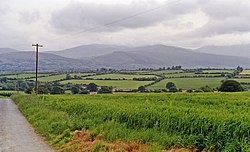
Glenahiry countryside, Ballydonagh townland
Barony map of County Waterford, 1900; Glenahiry is coloured yellow, in the north.
Sovereign stateIreland
ProvinceMunster
CountyWaterford
Area
 • Total157.58 km2 (60.84 sq mi)

Glenahiry (Irish: Gleann na hUidhre[1]) is a baronyinCounty Waterford, Ireland.[2][3]

Etymology

[edit]

Glenahiry barony is derived from the Irish for "valley of the River Nier", which is called An Uidhir ("dun, brown") in Irish.[4] The Nier joins the River Suir at Ballymakee.[5]

Geography

[edit]

Glenahiry is located in northern County Waterford, east of the River Suir and west of the Comeragh Mountains. The Nier Valley Woodlands are a Special Area of Conservation.[6]

History

[edit]

Glenahiry was the ancient territory of the Mac Cairbre (Carbery).[7][8][9]

Glenahiry was established as a barony by 1672.

List of settlements

[edit]

Below is a list of settlements in Glenahiry barony:

References

[edit]
  1. ^ "Gleann na hUidhre/Glenahiry". Logainm.ie.
  • ^ Survey, Ireland General Valuation and Boundary (18 December 2018). "County of Waterford, Barony of Glenahiry, Union of Clonmel: Valuation of the Several Parishes, Townlands, and Tenements, Contained in Said Barony, Made in Pursuance of the Act 9 & 10 Victoria, Cap. 110 ..." G. & J. Grierson, Her Majesty's Printers – via Google Books.
  • ^ Commission, Irish Manuscripts; Simington, Robert C. (18 December 2018). "The Civil Survey. A.D. 1654-1656: County of Waterford. With appendices: Muskerry Barony, Co. Cork: Kilkenny City and Liberties (part) also valuations, circa 1663-64, for Waterford and Cork cities". Stationery Office – via Google Books.
  • ^ "An Uidhir/River Nier". Logainm.ie.
  • ^ "Waterford". www.libraryireland.com.
  • ^ "Nier Valley Woodlands SAC - National Parks & Wildlife Service". www.npws.ie.
  • ^ "Garbery in Ireland". www.johngrenham.com.
  • ^ MacLysaght, Edward (19 April 1985). The Surnames of Ireland. Irish Academic Press. ISBN 9781911024644 – via Google Books.
  • ^ O'Laughlin, Michael C. (22 December 2018). The Book of Irish Families, Great & Small. Irish Roots Cafe. ISBN 9780940134096 – via Google Books.
  • ^ "Kilronan Church (Kilronan), County Waterford: Buildings of Ireland: National Inventory of Architectural Heritage". www.buildingsofireland.ie.

  • Retrieved from "https://en.wikipedia.org/w/index.php?title=Glenahiry&oldid=1147971405"

    Category: 
    Baronies of County Waterford
    Hidden categories: 
    Articles with short description
    Short description matches Wikidata
    Use dmy dates from December 2020
    Use Hiberno-English from December 2020
    All Wikipedia articles written in Hiberno-English
    Short description is different from Wikidata
    Pages using infobox settlement with no coordinates
    Articles containing Irish-language text


    This page was last edited on 3 April 2023, at 08:48 (UTC).

    Text is available under the Creative Commons Attribution-ShareAlike License 4.0; additional terms may apply. By using this site, you agree to the Terms of Use and Privacy Policy. Wikipedia® is a registered trademark of the Wikimedia Foundation, Inc., a non-profit organization.


    Privacy policy

    About Wikipedia

    Disclaimers

    Contact Wikipedia

    Code of Conduct

    Developers

    Statistics

    Cookie statement

    Mobile view


    Wikimedia Foundation
    Powered by MediaWiki