
| Glomma / Glåma | |
|---|---|

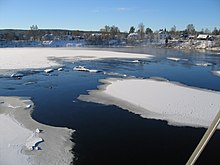
The Glomma at the Solbergfoss Hydroelectric Power Station
| |

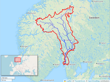
Map of the Glomma River watershed
| |
| Etymology | Old Norse, Glaumr, from raumr: "noise," "racket" |
| Location | |
| Country | Norway |
| Physical characteristics | |
| Source | Aursund |
| • location | Røros, Trøndelag, Norway |
| • coordinates | 62°37′06″N 11°48′11″E / 62.61833°N 11.80306°E / 62.61833; 11.80306 |
| • elevation | 690 m (2,260 ft) |
| Mouth | Fredrikstad |
• location | Fredrikstad, Østfold, Norway |
• coordinates | 59°13′04″N 10°55′51″E / 59.21778°N 10.93083°E / 59.21778; 10.93083 |
• elevation | 0 m (0 ft) |
| Length | 621 km (386 mi) |
| Basin size | 42,000 km2 (16,000 sq mi) |
| Discharge | |
| • average | 720 m3/s (25,000 cu ft/s) |
| • maximum | 4,700 m3/s (170,000 cu ft/s) |
| Basin features | |
| Tributaries | |
| • left | Vorma |
| • right | Rena |
| Designation | |
| Official name | Glomådeltaet |
| Designated | 12 November 2010 |
| Reference no. | 1954[1] |
The Glomma, or Glåma, is Norway's longest and most voluminous river. With a total length of 621 kilometres (386 miles), it has a drainage basin that covers fully 13% of Norway's surface area, all in the southern part of the country.[2]

At its fullest length, the river runs from Aursund lake near RørosinTrøndelag and runs into the OslofjordatFredrikstad. Major tributaries include the Vorma River, which drains Lake Mjøsa, joining the Glomma River at ÅrnesinNes. The Lågen drains into Lake Mjøsa, collecting drainage from the large Gudbrandsdalen and significantly increasing the Glomma's flow.[3]
Because it flows through some of the richest forest districts, it has historically been Norway's leading log-floating river. The combination of raw materials, water power, and easy transport has over the centuries encouraged industry along the Glomma. Some of the country's largest manufacturing and processing concerns are found around its mouth, where supplies of timber and hydropower have been backed by excellent port facilities.

The upper limit of the Glomma valley farms is variable, but typically runs about 500 metres (1,600 ft) in Østerdalen, slightly lower than in the Gudbrandsdalen, which reflects the colder climate. The treeline, with a light birch forest, rises to about 900 metres (3,000 ft) in Østerdalen. Above Røros the forest is restricted to the valley floor.
The upper river valleys of Norwegian rivers have distinctive names which are vestiges of earlier cultural distinctions such as building styles, traditional clothing or bunad and domestic crafts. The upper valley of the Glomma is the Østerdal (or East Valley).
Upon entering Lake ØyerenatFetsund, the Glomma has formed Europe's largest inland delta which reaches the opposite side of the lake, across its short axis. Some of the vast amount of silt that the Glomma deposits in Lake Øyeren is extracted to manufacture LECA building blocks widely used for in the construction of foundations in Norway.
The form Glomma is used in Østfold and Akershus counties, while in Innlandet and Trøndelag counties the river is called (and written) Glåma. An older form was Glaumr; another, in Old Norse, was Raumelfr, meaning a "loud noise" or "thunder" + "river".[4]
Several places are named after the river, for instance Glåmdal and Glåmos.